
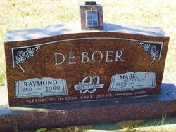
Raymond DeBoer
| Birth | : | 24 Dec 1921 Aurora County, South Dakota, USA |
| Death | : | 16 Feb 2000 Mitchell, Davison County, South Dakota, USA |
| Burial | : | Strood Cemetery, Strood, Medway Unitary Authority, England |
| Coordinate | : | 51.3900220, 0.4838640 |
| Description | : | Son of Dewey & Paulina (Paauw) DeBoer Sr. Married to Mabel Slykhuis on 10-1-1941 at Harrison, SD. Served in the U.S. Army Air Corps 1942/1945. Awarded the Air Medal, Silver Cluster, Four Oak Leaf Cluster, four Battle Stars and flew 57 missions in the European Theater of War. He was inducted into the South Dakota Aviation Hall of Fame in 1994. |
frequently asked questions (FAQ):
-
Where is Raymond DeBoer's memorial?
Raymond DeBoer's memorial is located at: Strood Cemetery, Strood, Medway Unitary Authority, England.
-
When did Raymond DeBoer death?
Raymond DeBoer death on 16 Feb 2000 in Mitchell, Davison County, South Dakota, USA
-
Where are the coordinates of the Raymond DeBoer's memorial?
Latitude: 51.3900220
Longitude: 0.4838640
Family Members:
Parent
Spouse

Siblings
Flowers:


Nearby Cemetories:
1. Strood Cemetery
Strood, Medway Unitary Authority, England
Coordinate: 51.3900220, 0.4838640
2. St Nicholas with St Mary Churchyard
Strood, Medway Unitary Authority, England
Coordinate: 51.3959790, 0.4931350
3. St Margaret Churchyard
Rochester, Medway Unitary Authority, England
Coordinate: 51.3849380, 0.4993630
4. Rochester Castle Moat Burial Ground
Rochester, Medway Unitary Authority, England
Coordinate: 51.3894140, 0.5024580
5. Rochester Cathedral
Rochester, Medway Unitary Authority, England
Coordinate: 51.3889750, 0.5031160
6. St Nicholas Churchyard
Rochester, Medway Unitary Authority, England
Coordinate: 51.3894170, 0.5035320
7. Rochester Baptist Church
Rochester, Medway Unitary Authority, England
Coordinate: 51.3871570, 0.5052370
8. St. Margaret's Cemetery
Rochester, Medway Unitary Authority, England
Coordinate: 51.3777000, 0.5011600
9. St Matthew Churchyard
Borstal, Medway Unitary Authority, England
Coordinate: 51.3736150, 0.4868020
10. St. Nicholas's Cemetery
Rochester, Medway Unitary Authority, England
Coordinate: 51.3780081, 0.5021076
11. All Saints Churchyard
Frindsbury, Medway Unitary Authority, England
Coordinate: 51.4004440, 0.5058970
12. Fort Pitt Military Cemetery
Rochester, Medway Unitary Authority, England
Coordinate: 51.3769790, 0.5114570
13. Chatham Unitarian Church
Chatham, Medway Unitary Authority, England
Coordinate: 51.3826090, 0.5195850
14. St Mary Churchyard
Chatham, Medway Unitary Authority, England
Coordinate: 51.3874550, 0.5244280
15. St. Michael and All Angels Churchyard
Cuxton, Medway Unitary Authority, England
Coordinate: 51.3714120, 0.4546760
16. Chatham Burial Ground
Chatham, Medway Unitary Authority, England
Coordinate: 51.3849900, 0.5272600
17. Brompton War Memorial
Chatham, Medway Unitary Authority, England
Coordinate: 51.3932140, 0.5293660
18. St John Evangelist Churchyard
Higham, Gravesham Borough, England
Coordinate: 51.4162102, 0.4616890
19. Chatham Naval Memorial
Chatham, Medway Unitary Authority, England
Coordinate: 51.3836479, 0.5321670
20. Chatham Maidstone Road Cemetery
Chatham, Medway Unitary Authority, England
Coordinate: 51.3703300, 0.5227600
21. St George Churchyard
Chatham, Medway Unitary Authority, England
Coordinate: 51.3974070, 0.5346770
22. St Philip and St James Churchyard
Upnor, Medway Unitary Authority, England
Coordinate: 51.4106250, 0.5250480
23. Chatham Palmerston Road Cemetery
Chatham, Medway Unitary Authority, England
Coordinate: 51.3678600, 0.5267300
24. All Saints Churchyard
Wouldham, Tonbridge and Malling Borough, England
Coordinate: 51.3528130, 0.4580580