
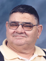
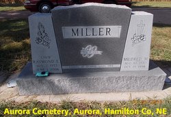
Raymond Earl Miller
| Birth | : | 7 Nov 1933 Oto, Woodbury County, Iowa, USA |
| Death | : | 1 Jun 2006 Aurora, Hamilton County, Nebraska, USA |
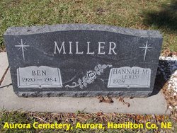
| Burial | : | Calvary Cemetery, West Point, Lee County, USA |
| Coordinate | : | 40.7127991, -91.4561005 |
| Description | : | Raymond Earl Miller, the son of William Lloyd and Lorena Pearl (Stratton) Miller, was born in Oto, Iowa on November 7, 1933 and died in Aurora, Nebraska on June 1, 2006, at the age of 72. He grew up in Oto, Iowa until 1937, when his family moved to Osceola, Nebraska where he graduated from high school. After high school Raymond went to work for the Ford Garage in Osceola. On February 17, 1963, he was united in marriage to Mildred May Miller at Osceola. In February 1969, they moved to Aurora and Raymond started working for Overland Concrete, where... Read More |
frequently asked questions (FAQ):
-
Where is Raymond Earl Miller's memorial?
Raymond Earl Miller's memorial is located at: Calvary Cemetery, West Point, Lee County, USA.
-
When did Raymond Earl Miller death?
Raymond Earl Miller death on 1 Jun 2006 in Aurora, Hamilton County, Nebraska, USA
-
Where are the coordinates of the Raymond Earl Miller's memorial?
Latitude: 40.7127991
Longitude: -91.4561005
Family Members:
Parent

Spouse

Siblings
Flowers:


Nearby Cemetories:
1. Calvary Cemetery
West Point, Lee County, USA
Coordinate: 40.7127991, -91.4561005
2. West Point Cemetery
West Point, Lee County, USA
Coordinate: 40.7183600, -91.4487500
3. Pitman Family Pioneer Cemetery
Pleasant Ridge Township, Lee County, USA
Coordinate: 40.7108002, -91.4180984
4. Van Hynning Family Cemetery
West Point, Lee County, USA
Coordinate: 40.7038630, -91.4189880
5. Creel Farm Cemetery
West Point, Lee County, USA
Coordinate: 40.7472220, -91.4752780
6. J Goldsmiths Burying Ground
West Point, Lee County, USA
Coordinate: 40.7333730, -91.4973000
7. Blacksmith Cemetery
Franklin, Lee County, USA
Coordinate: 40.7078018, -91.5096970
8. Pitman Chapel Pioneer Cemetery
Pleasant Ridge Township, Lee County, USA
Coordinate: 40.7150002, -91.3968964
9. Busch Mennonite Cemetery
Lee County, USA
Coordinate: 40.6679300, -91.4783900
10. Hoover Cemetery
Franklin, Lee County, USA
Coordinate: 40.6960983, -91.5160980
11. Judy Cemetery
West Point, Lee County, USA
Coordinate: 40.6622000, -91.4744000
12. Saint Peters United Church of Christ Cemetery
Franklin, Lee County, USA
Coordinate: 40.6674995, -91.4974976
13. Saint Peters Presbyterian Cemetery
Franklin, Lee County, USA
Coordinate: 40.6603012, -91.4831009
14. Franklin Cemetery
Franklin, Lee County, USA
Coordinate: 40.6683006, -91.5066986
15. Enslow Cemetery
Lee County, USA
Coordinate: 40.7553500, -91.4012100
16. Williamson Cemetery
West Point, Lee County, USA
Coordinate: 40.7727814, -91.4205627
17. Woolens Corner Pioneer Cemetery
West Point, Lee County, USA
Coordinate: 40.7780500, -91.4402200
18. New Garden Quaker Cemetery
Lee County, USA
Coordinate: 40.7780900, -91.4964100
19. Saint James Cemetery
Saint Paul, Lee County, USA
Coordinate: 40.7696000, -91.5185900
20. Bonnell Cemetery
Franklin, Lee County, USA
Coordinate: 40.7057991, -91.5635986
21. Woodmansee Cemetery
Lee County, USA
Coordinate: 40.7651900, -91.3725010
22. Applegate Family Burial Ground
Viele, Lee County, USA
Coordinate: 40.6285460, -91.4641000
23. Everhart Cemetery
Donnellson, Lee County, USA
Coordinate: 40.6310997, -91.4891968
24. McCracken Cemetery
Lee County, USA
Coordinate: 40.7274200, -91.5695500