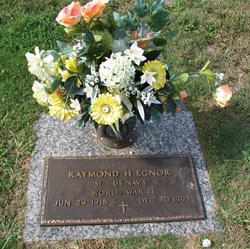
Raymond Hallie Egnor
| Birth | : | 29 Jun 1918 Lincoln County, West Virginia, USA |
| Death | : | 30 Dec 1993 East Saint Louis, St. Clair County, Illinois, USA |
| Burial | : | Knoll Crest Cemetery, Naper, Boyd County, USA |
| Coordinate | : | 42.9589005, -99.0875015 |
| Description | : | Reference: Curry Funeral Home Records, Alum Creek, 1950-2000, as compiled by the Lincoln County Genealogical Society Age 75 Residence: Centerville Township, Illimois Marital status: divorced Father: Delbert Egnor Mother: Melinda Peck Burial: Madison Memory Gardens, Madison, WV |
frequently asked questions (FAQ):
-
Where is Raymond Hallie Egnor's memorial?
Raymond Hallie Egnor's memorial is located at: Knoll Crest Cemetery, Naper, Boyd County, USA.
-
When did Raymond Hallie Egnor death?
Raymond Hallie Egnor death on 30 Dec 1993 in East Saint Louis, St. Clair County, Illinois, USA
-
Where are the coordinates of the Raymond Hallie Egnor's memorial?
Latitude: 42.9589005
Longitude: -99.0875015
Family Members:
Parent
Spouse
Siblings
Children
Flowers:
Nearby Cemetories:
1. Knoll Crest Cemetery
Naper, Boyd County, USA
Coordinate: 42.9589005, -99.0875015
2. Sacred Heart Cemetery
Naper, Boyd County, USA
Coordinate: 42.9586400, -99.0905900
3. Lutheran Cemetery
Naper, Boyd County, USA
Coordinate: 42.9585980, -99.1268810
4. German Cemetery
Naper, Boyd County, USA
Coordinate: 42.9696999, -99.1350021
5. Mount Zion Cemetery
Naper, Boyd County, USA
Coordinate: 42.9701200, -99.0183400
6. Baptist Cemetery
Naper, Boyd County, USA
Coordinate: 42.9730988, -99.1564026
7. Saint Francis Xavier Cemetery
Saint Charles, Gregory County, USA
Coordinate: 43.0094337, -99.1375152
8. Milks Camp Episcopal Cemetery
Saint Charles, Gregory County, USA
Coordinate: 43.0378199, -99.1552354
9. Ponca Creek UCC Cemetery
Gregory County, USA
Coordinate: 43.0451800, -99.1491700
10. Southside Cemetery
Holt County, USA
Coordinate: 42.8842139, -98.9931842
11. Oak Dale Cemetery
Naper, Boyd County, USA
Coordinate: 42.8847008, -99.1939011
12. Pleasant Valley Cemetery
Bonesteel, Gregory County, USA
Coordinate: 43.0327988, -98.9796982
13. Adams Cemetery
Holt County, USA
Coordinate: 42.8706000, -98.9694500
14. Highland Cemetery
Fairfax, Gregory County, USA
Coordinate: 43.0236015, -98.8930969
15. Trinity Lutheran Cemetery
Fairfax, Gregory County, USA
Coordinate: 43.0102997, -98.8842010
16. Saint Marys Cemetery
Bonesteel, Gregory County, USA
Coordinate: 43.0816994, -98.9413986
17. Rosebud Cemetery
Bonesteel, Gregory County, USA
Coordinate: 43.0835991, -98.9405975
18. Immanuel Lutheran Cemetery
Jamison, Keya Paha County, USA
Coordinate: 42.9977989, -99.3139038
19. Saints Peter and Paul Cemetery
Butte, Boyd County, USA
Coordinate: 42.9221992, -98.8593979
20. Butte Cemetery
Butte, Boyd County, USA
Coordinate: 42.9235992, -98.8585968
21. Herrick Cemetery
Herrick, Gregory County, USA
Coordinate: 43.1110000, -99.1970000
22. Saint Anthonys Cemetery
Fairfax, Gregory County, USA
Coordinate: 43.0532990, -98.8835983
23. Spotted Tail Cemetery
Jamison, Keya Paha County, USA
Coordinate: 42.9799995, -99.3324966
24. Cleveland Cemetery
Holt County, USA
Coordinate: 42.7761002, -99.1091995


