
| Birth | : | 5 Dec 1924 Parker, Turner County, South Dakota, USA |
| Death | : | 6 Oct 2019 Lennox, Lincoln County, South Dakota, USA |
| Burial | : | Mount Hope Cemetery, Ashland, Ashland County, USA |
| Coordinate | : | 46.5621986, -90.9039001 |
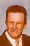
| Description | : | Raymond Harms, 94, of Lennox, SD, died Sunday, October 6, 2019 at his home under hospice care. Raymond Lee Harms was born on December 5, 1924, at Parker, SD, the son of Herman and Olive (Rector) Harms. He grew up in rural Chancellor and attended Middleton District 20 rural school. He served in the US Army, in Germany, during WWII, from 1945 until his honorable discharge in 1946. On December 11, 1945 he was united in marriage to Beulah Gors. The couple lived in Chancellor until moving to their farm southwest of Chancellor in 1948. In 1979 they... Read More |
frequently asked questions (FAQ):
-
Where is Raymond Lee Harms's memorial?
Raymond Lee Harms's memorial is located at: Mount Hope Cemetery, Ashland, Ashland County, USA.
-
When did Raymond Lee Harms death?
Raymond Lee Harms death on 6 Oct 2019 in Lennox, Lincoln County, South Dakota, USA
-
Where are the coordinates of the Raymond Lee Harms's memorial?
Latitude: 46.5621986
Longitude: -90.9039001
Family Members:
Parent

Spouse

Siblings
Flowers:


Nearby Cemetories:
1. Mount Hope Cemetery
Ashland, Ashland County, USA
Coordinate: 46.5621986, -90.9039001
2. Saint Agnes Cemetery
Ashland, Ashland County, USA
Coordinate: 46.5614014, -90.9075012
3. B'Nai Israel Cemetery
Ashland, Ashland County, USA
Coordinate: 46.5600014, -90.9116974
4. Heitsch Family Burial Plot
Barksdale, Bayfield County, USA
Coordinate: 46.6315661, -90.9560996
5. Church Corner Cemetery
Washburn, Bayfield County, USA
Coordinate: 46.6595000, -90.9889000
6. Moquah National Cemetery
Moquah, Bayfield County, USA
Coordinate: 46.5702860, -91.0718390
7. Moquah Cemetery
Moquah, Bayfield County, USA
Coordinate: 46.5701980, -91.0731530
8. Woodland Cemetery
Washburn, Bayfield County, USA
Coordinate: 46.6845100, -90.9049800
9. Calvary Cemetery
Washburn, Bayfield County, USA
Coordinate: 46.6852989, -90.9008026
10. Saints Peter and Paul Catholic Cemetery
Moquah, Bayfield County, USA
Coordinate: 46.5698013, -91.0842972
11. Saint Peters Cemetery
Benoit, Bayfield County, USA
Coordinate: 46.5236015, -91.0781021
12. Old Apostolic Lutheran Cemetery
Marengo, Ashland County, USA
Coordinate: 46.4408640, -90.8473530
13. Bad River Cemetery
Odanah, Ashland County, USA
Coordinate: 46.5992100, -90.7208900
14. Saint Anne Catholic Cemetery
Sanborn, Ashland County, USA
Coordinate: 46.4294281, -90.9071426
15. Benoit Cemetery
Benoit, Bayfield County, USA
Coordinate: 46.5026016, -91.0794983
16. Old Calvary Cemetery
Washburn, Bayfield County, USA
Coordinate: 46.7072906, -90.8947830
17. Fish Creek Cemetery
Ino, Bayfield County, USA
Coordinate: 46.5241165, -91.1252823
18. Moland Lutheran Church Cemetery
Mason, Bayfield County, USA
Coordinate: 46.4131012, -90.9897995
19. Mason Cemetery
Mason, Bayfield County, USA
Coordinate: 46.4401800, -91.0555800
20. Maple Grove Cemetery
Marengo, Ashland County, USA
Coordinate: 46.3852997, -90.8606033
21. Moe Cemetery
Mason, Bayfield County, USA
Coordinate: 46.3789200, -90.9498900
22. Saint Florians Cemetery
Ino, Bayfield County, USA
Coordinate: 46.5161438, -91.1750412
23. Birch Lake Cemetery
Mason, Bayfield County, USA
Coordinate: 46.3569603, -90.9666595
24. Mount Hope Cemetery
High Bridge, Ashland County, USA
Coordinate: 46.3859700, -90.7353300