
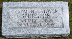

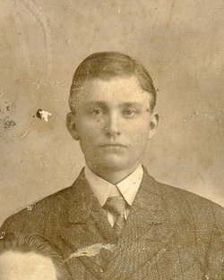
Raymond Stover Spurgeon
| Birth | : | 5 Jan 1888 |
| Death | : | 21 Aug 1984 |
| Burial | : | Moody Cemetery, Marion, Marion County, USA |
| Coordinate | : | 34.2548409, -79.4154968 |
| Description | : | Raymond Stover Spurgeon, 96, of Des Moines died of a heart ailment at his home on Aug. 21. Mr. Spurgeon was born in Kansas and was a rural Adel resident and a farmer most of his life. He moved to Des Moines following retirement several years ago. He was a member of the Panther Creek Church of the Brethren. Survivors include two sisters, Etta Brenton of Des Moines and Blanche Roland of Ames. Ray Spurgeon died Aug. 21 at the McGinnis Rest Home in Des Moines. He lived his entire life in Community Center until retiring to the rest home. |
frequently asked questions (FAQ):
-
Where is Raymond Stover Spurgeon's memorial?
Raymond Stover Spurgeon's memorial is located at: Moody Cemetery, Marion, Marion County, USA.
-
When did Raymond Stover Spurgeon death?
Raymond Stover Spurgeon death on 21 Aug 1984 in
-
Where are the coordinates of the Raymond Stover Spurgeon's memorial?
Latitude: 34.2548409
Longitude: -79.4154968
Family Members:
Parent

Siblings
Flowers:


Nearby Cemetories:
1. Moody Cemetery
Marion, Marion County, USA
Coordinate: 34.2548409, -79.4154968
2. Sunset Gardens Cemetery
Spring Branch, Marion County, USA
Coordinate: 34.2500300, -79.4057900
3. Saint Phillips United Methodist Church Cemetery
Spring Branch, Marion County, USA
Coordinate: 34.2491700, -79.4062600
4. Greater Fork Chapel AME Church Cemetery
Marion, Marion County, USA
Coordinate: 34.2496986, -79.3929977
5. Moody-Berry Cemetery
Marion County, USA
Coordinate: 34.2564011, -79.3908005
6. Platt - Deer Cemetery
Marion, Marion County, USA
Coordinate: 34.2675876, -79.3959196
7. Spring Branch Baptist Church Cemetery
Spring Branch, Marion County, USA
Coordinate: 34.2420998, -79.3957977
8. Spring Branch Cemetery
Spring Branch, Marion County, USA
Coordinate: 34.2425003, -79.3925018
9. Ebenezer Methodist Church Cemetery
Temperance Hill, Marion County, USA
Coordinate: 34.2858009, -79.4105988
10. Turner Cemetery
Marion County, USA
Coordinate: 34.2860985, -79.4163971
11. Wall Mausoleum
Marion, Marion County, USA
Coordinate: 34.2344800, -79.3823000
12. Christmas Cemetery
Sellers, Marion County, USA
Coordinate: 34.2841988, -79.4381027
13. End of the Road Cemetery
Marion, Marion County, USA
Coordinate: 34.2240620, -79.3912079
14. Bethlehem Freewill Baptist Church Cemetery
Marion, Marion County, USA
Coordinate: 34.2806200, -79.3820900
15. Lane Cemetery
Temperance Hill, Marion County, USA
Coordinate: 34.2860985, -79.3891983
16. Antioch Church Cemetery
Sellers, Marion County, USA
Coordinate: 34.2832000, -79.4482000
17. Stewart Family Cemetery
Marion County, USA
Coordinate: 34.2888985, -79.3861008
18. Fore Cemetery
Sellers, Marion County, USA
Coordinate: 34.2836570, -79.4538520
19. Lane Cemetery
Marion County, USA
Coordinate: 34.2999992, -79.4049988
20. Union Baptist Church Cemetery
Temperance Hill, Marion County, USA
Coordinate: 34.2871475, -79.3754730
21. Lee Cemetery
Marion County, USA
Coordinate: 34.2971992, -79.3918991
22. Gasque Cemetery
Marion County, USA
Coordinate: 34.2098000, -79.3971300
23. Bryant Cemetery
Marion County, USA
Coordinate: 34.2903800, -79.3764400
24. Sellers Chapel Baptist Church Cemetery
Sellers, Marion County, USA
Coordinate: 34.2808000, -79.4697000