
Rebecca Newell Woodford
| Birth | : | Jan 1643 Farmington, Hartford County, Connecticut, USA |
| Death | : | 9 May 1711 Farmington, Hartford County, Connecticut, USA |
| Burial | : | Sardis United Methodist Church Cemetery, Amherst, Amherst County, USA |
| Coordinate | : | 37.6197970, -79.1090860 |
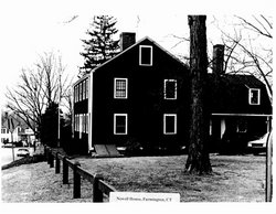
| Description | : | Rebecca NEWELL was born in Jan 1643 in Farmington, Hartford, Connecticut, U.S.A.. She died on 9 May 1711 in Farmington, Hartford, Connecticut, U.S.A.. She was buried in May 1711 in Hartford, Hartford Co., Connecticut, U.S.A.. Rebeckah was the eldest child of Thomas and Rebeckah. She was born in January 1643. She married her next door neighbor, Joseph Woodford. The Newell house stood facing North Meadow Lane, now Farmington Ave; The Woodford house faced on Waterville Road. The marriage of Rebeckah Newell and Joseph Woodford began a line of several generations of family members who lived in the Newell-Woodford house at what... Read More |
frequently asked questions (FAQ):
-
Where is Rebecca Newell Woodford's memorial?
Rebecca Newell Woodford's memorial is located at: Sardis United Methodist Church Cemetery, Amherst, Amherst County, USA.
-
When did Rebecca Newell Woodford death?
Rebecca Newell Woodford death on 9 May 1711 in Farmington, Hartford County, Connecticut, USA
-
Where are the coordinates of the Rebecca Newell Woodford's memorial?
Latitude: 37.6197970
Longitude: -79.1090860
Family Members:


Flowers:


Nearby Cemetories:
1. Sardis United Methodist Church Cemetery
Amherst, Amherst County, USA
Coordinate: 37.6197970, -79.1090860
2. Tudor Hall Cemetery
Amherst, Amherst County, USA
Coordinate: 37.6220820, -79.1097390
3. Burford Family Cemetery
Amherst, Amherst County, USA
Coordinate: 37.6153800, -79.1277400
4. John Hill Watts Cemetery
Amherst, Amherst County, USA
Coordinate: 37.6153800, -79.1282800
5. Tyree-Rutherford Cemetery
Amherst, Amherst County, USA
Coordinate: 37.6234100, -79.1381160
6. Tinsley Family Cemetery
Amherst, Amherst County, USA
Coordinate: 37.6418810, -79.1354850
7. Henley Cemetery
Amherst, Amherst County, USA
Coordinate: 37.6472015, -79.1294022
8. Harrison Cemetery
Amherst, Amherst County, USA
Coordinate: 37.6142006, -79.0614014
9. Lee Cemetery
Amherst, Amherst County, USA
Coordinate: 37.6590920, -79.0858130
10. Smith - Sandidge Cemetery
Amherst, Amherst County, USA
Coordinate: 37.6590940, -79.0858100
11. Miller Cemetery
Amherst, Amherst County, USA
Coordinate: 37.6111200, -79.0531700
12. Garland Cemetery
Amherst, Amherst County, USA
Coordinate: 37.5861200, -79.0703390
13. Tinsley Plot
Amherst County, USA
Coordinate: 37.6231079, -79.0476088
14. Hicks-Morris-Peters Cemetery
Monroe, Amherst County, USA
Coordinate: 37.5969009, -79.1671982
15. New Jerusalem Baptist Church Cemetery
Amherst, Amherst County, USA
Coordinate: 37.6725870, -79.1098220
16. Smyrna United Methodist Church Cemetery
Monroe, Amherst County, USA
Coordinate: 37.5804590, -79.1563860
17. Mount Shiloh Baptist Church Cemetery
Monroe, Amherst County, USA
Coordinate: 37.5708490, -79.1456080
18. Saint Francis of Assisi Columbarium
Amherst, Amherst County, USA
Coordinate: 37.5817250, -79.0557290
19. Christian Aid Society Cemetery
Amherst, Amherst County, USA
Coordinate: 37.5752983, -79.0578003
20. Sweet Briar Plantation Burial Grounds
Sweet Briar Station, Amherst County, USA
Coordinate: 37.5615930, -79.0856440
21. Saint Pauls Cemetery
Monroe, Amherst County, USA
Coordinate: 37.5605200, -79.1295330
22. Amherst Cemetery
Amherst, Amherst County, USA
Coordinate: 37.5964012, -79.0366974
23. Thomas Family Cemetery
Clifford, Amherst County, USA
Coordinate: 37.6592080, -79.0450240
24. Parr Cemetery
Amherst, Amherst County, USA
Coordinate: 37.6777992, -79.0738983