

Joseph Woodford I
| Birth | : | 1645 Hartford County, Connecticut, USA |
| Death | : | 10 Dec 1710 Farmington, Hartford County, Connecticut, USA |
| Burial | : | Ramsgate Cemetery, Ramsgate, Thanet District, England |
| Coordinate | : | 51.3427270, 1.4209750 |
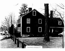
| Description | : | He married Rebecca Newell, daughter of Thomas Newell and Rebecca Olmstead. He wrote his will on 10 December 1701 and it was probated on 25 October 1710. (Death date was probably around Nov 6, 1710 per Brooke Harlowe) The Newell house stood facing North Meadow Lane, now Farmington Ave; The Woodford house faced on Waterville Road. Joseph Woodford and Rebeckah Newell were next door neighbors. The marriage of Rebeckah Newell and Joseph Woodford began a line of several generations of family members who lived in the Newell-Woodford house at what came to be called Newell Corners. In 1706, Joseph and Rebeckah sold... Read More |
frequently asked questions (FAQ):
-
Where is Joseph Woodford I's memorial?
Joseph Woodford I's memorial is located at: Ramsgate Cemetery, Ramsgate, Thanet District, England.
-
When did Joseph Woodford I death?
Joseph Woodford I death on 10 Dec 1710 in Farmington, Hartford County, Connecticut, USA
-
Where are the coordinates of the Joseph Woodford I's memorial?
Latitude: 51.3427270
Longitude: 1.4209750
Family Members:
Parent
Spouse
Siblings
Children

Flowers:


Nearby Cemetories:
1. Ramsgate Cemetery
Ramsgate, Thanet District, England
Coordinate: 51.3427270, 1.4209750
2. St. George's Churchyard
Ramsgate, Thanet District, England
Coordinate: 51.3360951, 1.4179783
3. St Laurence Churchyard
St Lawrence, Thanet District, England
Coordinate: 51.3377140, 1.4009720
4. St. Augustine Roman Catholic Churchyard
Ramsgate, Thanet District, England
Coordinate: 51.3282920, 1.4101230
5. Baptist Church Cemetery
St Peters, Thanet District, England
Coordinate: 51.3648280, 1.4186530
6. St. Peter the Apostle Churchyard
St Peters, Thanet District, England
Coordinate: 51.3650400, 1.4190700
7. Margate Cemetery
Margate, Thanet District, England
Coordinate: 51.3739880, 1.3762730
8. Thanet Crematorium
Margate, Thanet District, England
Coordinate: 51.3745290, 1.3765230
9. St John the Baptist Church
Margate, Thanet District, England
Coordinate: 51.3837680, 1.3832260
10. Trinity Square War Memorials
Margate, Thanet District, England
Coordinate: 51.3902090, 1.3851790
11. Minster Cemetery
Minster-in-Thanet, Thanet District, England
Coordinate: 51.3423100, 1.3160550
12. St Mary the Virgin Church
Minster-in-Thanet, Thanet District, England
Coordinate: 51.3305810, 1.3156720
13. All Saints Churchyard
Birchington, Thanet District, England
Coordinate: 51.3736580, 1.3059360
14. St .Mary's Churchyard
Sandwich, Dover District, England
Coordinate: 51.2771930, 1.3386580
15. St. Peter's Churchyard
Sandwich, Dover District, England
Coordinate: 51.2747680, 1.3405120
16. St Clement's Church
Sandwich, Dover District, England
Coordinate: 51.2736510, 1.3427270
17. St Nicholas-at-Wade Cemetery
St Nicholas at Wade, Thanet District, England
Coordinate: 51.3578344, 1.2534168
18. St. Nicholas' Churchyard
St Nicholas at Wade, Thanet District, England
Coordinate: 51.3542160, 1.2517980
19. Saint Mary The Virgin Churchyard
Woodnesborough, Dover District, England
Coordinate: 51.2628240, 1.3073810
20. St. Nicholas Churchyard
Ash, Dover District, England
Coordinate: 51.2786800, 1.2786400
21. Church of Saint George at Ham
Eastry, Dover District, England
Coordinate: 51.2444830, 1.3319350
22. Deal Congregational Church
Deal, Dover District, England
Coordinate: 51.2264163, 1.4024282
23. All Saints Churchyard
Stourmouth, Dover District, England
Coordinate: 51.3202600, 1.2365520
24. St Mary the Virgin Churchyard
Eastry, Dover District, England
Coordinate: 51.2453000, 1.3100000