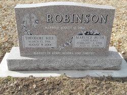
Rev Theodore Kile “Ted” Robinson
| Birth | : | 15 Mar 1936 Galva, Henry County, Illinois, USA |
| Death | : | 9 Aug 2014 Lincoln, Lancaster County, Nebraska, USA |
| Burial | : | Saint Paul's Lutheran Cemetery, Gage County, USA |
| Coordinate | : | 40.4186330, -96.8187780 |
| Description | : | Rev. Theodore (Ted) K. Robinson, 78 of Beatrice died Saturday August 9, 2014 at the Waterford at Wilderness Hills in Lincoln. He was born March 15, 1936 at Galva, Illinois. He was raised in Phoenix, AZ and graduated from Phoenix Union High School in May of 1955. He graduated from Arizona State University in May of 1959 and then in 1960 he entered Pacific Lutheran Theological Seminary in Berkeley, CA. where he graduated in 1964. He married Marlyce R. Pohlman on August 12, 1962 at St. Paul's (Soap Creek) Lutheran Church of rural DeWitt. He served churches in Orland, CA; Osborne,... Read More |
frequently asked questions (FAQ):
-
Where is Rev Theodore Kile “Ted” Robinson's memorial?
Rev Theodore Kile “Ted” Robinson's memorial is located at: Saint Paul's Lutheran Cemetery, Gage County, USA.
-
When did Rev Theodore Kile “Ted” Robinson death?
Rev Theodore Kile “Ted” Robinson death on 9 Aug 2014 in Lincoln, Lancaster County, Nebraska, USA
-
Where are the coordinates of the Rev Theodore Kile “Ted” Robinson's memorial?
Latitude: 40.4186330
Longitude: -96.8187780
Family Members:
Flowers:
Nearby Cemetories:
1. Saint Paul's Lutheran Cemetery
Gage County, USA
Coordinate: 40.4186330, -96.8187780
2. Rose Hill Cemetery
Gage County, USA
Coordinate: 40.3936005, -96.8553009
3. Clatonia Cemetery
Clatonia, Gage County, USA
Coordinate: 40.4614500, -96.8556600
4. Zion Evangelical Lutheran Cemetery
Clatonia, Gage County, USA
Coordinate: 40.4666910, -96.8749310
5. Highland Center Cemetery
Cortland, Gage County, USA
Coordinate: 40.4660988, -96.7611008
6. Trinity Cemetery
Clatonia, Gage County, USA
Coordinate: 40.4508018, -96.8936005
7. Marsh Cemetery
Clatonia, Gage County, USA
Coordinate: 40.4867230, -96.8185310
8. Sykes Family Cemetery
Clatonia, Gage County, USA
Coordinate: 40.4868330, -96.8186260
9. Dolen Cemetery
Gage County, USA
Coordinate: 40.3494950, -96.8225930
10. Immanuel Cemetery
Gage County, USA
Coordinate: 40.5088005, -96.8133011
11. Oak Grove Cemetery
De Witt, Saline County, USA
Coordinate: 40.4049988, -96.9483032
12. Christ Lutheran Church Cemetery
Pickrell, Gage County, USA
Coordinate: 40.4079410, -96.6848370
13. Pleasant View Cemetery
Pickrell, Gage County, USA
Coordinate: 40.3493240, -96.7101000
14. Cortland Cemetery
Cortland, Gage County, USA
Coordinate: 40.4879200, -96.7041250
15. Saint James Cemetery
Cortland, Gage County, USA
Coordinate: 40.4886050, -96.7036050
16. Austin Creek Cemetery
Beatrice, Gage County, USA
Coordinate: 40.3282280, -96.7233020
17. First Trinity Lutheran Cemetery
Beatrice, Gage County, USA
Coordinate: 40.3053600, -96.8794400
18. Freeman Cemetery
Beatrice, Gage County, USA
Coordinate: 40.2966933, -96.8435666
19. Hallam Community Cemetery
Hallam, Lancaster County, USA
Coordinate: 40.5419006, -96.7885971
20. Saint Joseph Cemetery
Beatrice, Gage County, USA
Coordinate: 40.3054700, -96.7460700
21. Homestead National Historical Park
Beatrice, Gage County, USA
Coordinate: 40.2864800, -96.8271100
22. First Mennonite Church Cemetery
Beatrice, Gage County, USA
Coordinate: 40.2856800, -96.8120500
23. Sunny Side Cemetery
Wilber, Saline County, USA
Coordinate: 40.4942017, -96.9685974
24. Sunnyside Cemetery
Cortland, Gage County, USA
Coordinate: 40.4799200, -96.6511800


