
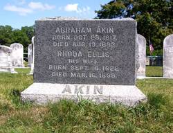
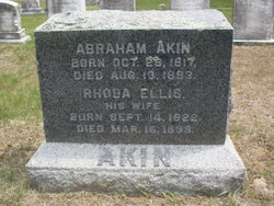
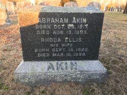
Rhoda Ellis Baker Akin
| Birth | : | 14 Sep 1822 |
| Death | : | 16 Mar 1899 |
| Burial | : | Northern California Veterans Cemetery, Igo, Shasta County, USA |
| Coordinate | : | 40.4785400, -122.5422500 |
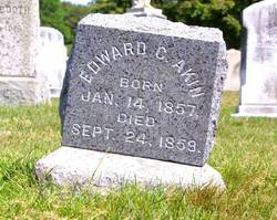
| Description | : | HUSBAND: Abraham Akin Jr. CHILDREN: Abraham H. Akin / Edward Clifton Akin |
frequently asked questions (FAQ):
-
Where is Rhoda Ellis Baker Akin's memorial?
Rhoda Ellis Baker Akin's memorial is located at: Northern California Veterans Cemetery, Igo, Shasta County, USA.
-
When did Rhoda Ellis Baker Akin death?
Rhoda Ellis Baker Akin death on 16 Mar 1899 in
-
Where are the coordinates of the Rhoda Ellis Baker Akin's memorial?
Latitude: 40.4785400
Longitude: -122.5422500
Family Members:
Parent
Spouse

Siblings
Children
Flowers:


Nearby Cemetories:
1. Northern California Veterans Cemetery
Igo, Shasta County, USA
Coordinate: 40.4785400, -122.5422500
2. Igo Cemetery
Igo, Shasta County, USA
Coordinate: 40.5130501, -122.5375977
3. Barbara Glass Gravesite
Shasta County, USA
Coordinate: 40.5067600, -122.5049700
4. Ono Cemetery
Ono, Shasta County, USA
Coordinate: 40.4692497, -122.6131821
5. Philpott Cemetery
Ono, Shasta County, USA
Coordinate: 40.4770012, -122.6194992
6. Fann-Slaughter Cemetery
Shasta County, USA
Coordinate: 40.4720500, -122.6280400
7. Happy Valley Cemetery
Redding, Shasta County, USA
Coordinate: 40.4668999, -122.4535980
8. Texas Springs Cemetery
Redding, Shasta County, USA
Coordinate: 40.5116844, -122.4516144
9. Middletown Cemetery
Redding, Shasta County, USA
Coordinate: 40.5392800, -122.4748700
10. Pinckney Cemetery
Cottonwood, Shasta County, USA
Coordinate: 40.3997002, -122.5180969
11. Whiskeytown Cemetery
Whiskeytown, Shasta County, USA
Coordinate: 40.5858002, -122.5381012
12. Shasta Masonic Cemetery
Shasta, Shasta County, USA
Coordinate: 40.5910492, -122.4859695
13. Shasta Union Cemetery
Shasta, Shasta County, USA
Coordinate: 40.6008682, -122.4906845
14. Shasta Catholic Cemetery
Shasta, Shasta County, USA
Coordinate: 40.6014950, -122.4917190
15. Charles Brownstein Gravesite
Shasta, Shasta County, USA
Coordinate: 40.6038810, -122.4992540
16. Saint Joseph Cemetery
Redding, Shasta County, USA
Coordinate: 40.5824509, -122.4310989
17. Shasta General Hospital Cemetery
Redding, Shasta County, USA
Coordinate: 40.5516000, -122.3894000
18. Shasta General Hospital Cemetery
Redding, Shasta County, USA
Coordinate: 40.5509200, -122.3841800
19. Old Saint Joseph Cemetery
Redding, Shasta County, USA
Coordinate: 40.5781326, -122.3912811
20. All Saints Episcopal Church Columbarium
Redding, Shasta County, USA
Coordinate: 40.5974900, -122.4010600
21. Redding Memorial Park
Redding, Shasta County, USA
Coordinate: 40.5894814, -122.3872833
22. Lawncrest Memorial Park
Redding, Shasta County, USA
Coordinate: 40.5732994, -122.3432999
23. Anderson District Cemetery
Anderson, Shasta County, USA
Coordinate: 40.4419518, -122.2967300
24. Oddfellows Cemetery
Anderson, Shasta County, USA
Coordinate: 40.4431590, -122.2907070