
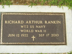
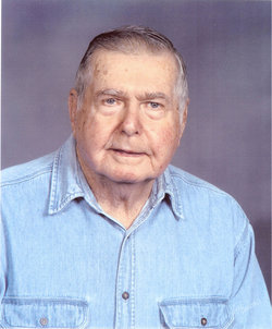
Richard Arthur “Dick” Rankin
| Birth | : | 12 Jun 1922 Floyds Knobs, Floyd County, Indiana, USA |
| Death | : | 17 Sep 2010 Louisville, Jefferson County, Kentucky, USA |
| Burial | : | Evergreen Cemetery, Mantorville, Dodge County, USA |
| Coordinate | : | 44.0619011, -92.7418976 |
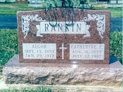
| Description | : | Published in The Evening News 9/19/2010 Funeral services for Richard A. "Dick" Rankin, 88, will be at 10 a.m. Wednesday, Sept. 22, at St. Mary of the Knobs Catholic Church, with military honors and burial to follow at the church cemetery. He died Friday, Sept. 17, 2010, at the VA Medical Center in Louisville with his family by his side. He was born June 12, 1922, in Floyds Knobs to the late Algor and Catherine (Andres) Rankin. He was a U.S. Navy veteran of World War II, known as "Tin Can Sailors." He was in the Civilian Conservation... Read More |
frequently asked questions (FAQ):
-
Where is Richard Arthur “Dick” Rankin's memorial?
Richard Arthur “Dick” Rankin's memorial is located at: Evergreen Cemetery, Mantorville, Dodge County, USA.
-
When did Richard Arthur “Dick” Rankin death?
Richard Arthur “Dick” Rankin death on 17 Sep 2010 in Louisville, Jefferson County, Kentucky, USA
-
Where are the coordinates of the Richard Arthur “Dick” Rankin's memorial?
Latitude: 44.0619011
Longitude: -92.7418976
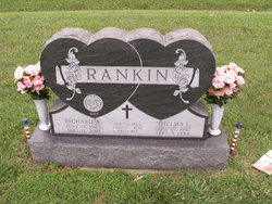
Family Members:
Parent

Spouse

Siblings
Children
Flowers:


Nearby Cemetories:
1. Evergreen Cemetery
Mantorville, Dodge County, USA
Coordinate: 44.0619011, -92.7418976
2. Saint Margaret Cemetery
Mantorville, Dodge County, USA
Coordinate: 44.0616989, -92.7435989
3. Maple Grove Cemetery
Kasson, Dodge County, USA
Coordinate: 44.0214005, -92.7553024
4. Wildwood Cemetery
Wasioja, Dodge County, USA
Coordinate: 44.0713997, -92.8142014
5. Milton Cemetery
Mantorville, Dodge County, USA
Coordinate: 44.1310997, -92.7463989
6. Othello Cemetery
Genoa, Olmsted County, USA
Coordinate: 44.1116982, -92.6641998
7. Byron Cemetery
Byron, Olmsted County, USA
Coordinate: 44.0359459, -92.6424713
8. Riverside Cemetery
Dodge Center, Dodge County, USA
Coordinate: 44.0393982, -92.8597031
9. Saint Michaels Catholic Cemetery
Olmsted County, USA
Coordinate: 44.1519012, -92.6588974
10. Berne Cemetery
Berne, Dodge County, USA
Coordinate: 44.1668091, -92.7794647
11. Concord Cemetery
Concord, Dodge County, USA
Coordinate: 44.1484032, -92.8330383
12. Mount Hope Cemetery
Rochester, Olmsted County, USA
Coordinate: 44.0703011, -92.5783005
13. South Zumbro Lutheran Church Cemetery
Salem Corners, Olmsted County, USA
Coordinate: 43.9517670, -92.6777878
14. Center Grove Cemetery
Olmsted County, USA
Coordinate: 44.1082993, -92.5785980
15. Riverside Cemetery
Salem Corners, Olmsted County, USA
Coordinate: 43.9785995, -92.6074982
16. County Line Cemetery
Pine Island, Goodhue County, USA
Coordinate: 44.1963882, -92.7113876
17. West Saint Olaf Cemetery
Vernon, Dodge County, USA
Coordinate: 43.9266701, -92.7177811
18. Ashland-Ripley Cemetery
Dodge Center, Dodge County, USA
Coordinate: 44.0222206, -92.9258270
19. Andrist Cemetery
Roscoe, Goodhue County, USA
Coordinate: 44.2027817, -92.7638931
20. Free Mission Cemetery
Roscoe, Goodhue County, USA
Coordinate: 44.2041702, -92.7116699
21. East Saint Olaf Lutheran Church Cemetery
Rock Dell, Olmsted County, USA
Coordinate: 43.9327812, -92.6383286
22. Zion Cemetery
Rock Dell, Olmsted County, USA
Coordinate: 43.9297218, -92.6377792
23. Riverside Cemetery
West Concord, Dodge County, USA
Coordinate: 44.1897011, -92.8600006
24. Saint Vincent de Paul Cemetery
West Concord, Dodge County, USA
Coordinate: 44.1674995, -92.9036026