

Richard Chandler “Dick” Freed
| Birth | : | 22 Jul 1925 Fort Dodge, Webster County, Iowa, USA |
| Death | : | 2 Dec 2020 Des Moines, Polk County, Iowa, USA |
| Burial | : | Dayton Cemetery, Dayton, Webster County, USA |
| Coordinate | : | 42.2675000, -94.0755000 |
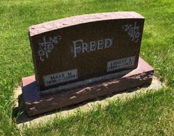
| Description | : | R.C. “Dick” Freed of Scottish Rite Park in Des Moines, Iowa got his wings December 2, 2020 at age 95. A private memorial will be held at the Dayton Memorial Cemetery Friday, December 11, where Dick and Eloise Freed’s ashes will be interred together. A public memorial will be announced later. Richard Chandler Freed was born on July, 22, 1925 at home on RR1 Ft. Dodge, Iowa to Maye and Earnest Freed. He had two older brothers. He graduated from Burnside High School in 1942. Dick enlisted in the Navy and served in WWII. After serving, he worked... Read More |
frequently asked questions (FAQ):
-
Where is Richard Chandler “Dick” Freed's memorial?
Richard Chandler “Dick” Freed's memorial is located at: Dayton Cemetery, Dayton, Webster County, USA.
-
When did Richard Chandler “Dick” Freed death?
Richard Chandler “Dick” Freed death on 2 Dec 2020 in Des Moines, Polk County, Iowa, USA
-
Where are the coordinates of the Richard Chandler “Dick” Freed's memorial?
Latitude: 42.2675000
Longitude: -94.0755000
Family Members:
Parent

Spouse
Siblings
Flowers:


Nearby Cemetories:
1. Dayton Cemetery
Dayton, Webster County, USA
Coordinate: 42.2675000, -94.0755000
2. Christ the King Catholic Cemetery
Dayton, Webster County, USA
Coordinate: 42.2601929, -94.0727539
3. Bass Cemetery
Dayton, Webster County, USA
Coordinate: 42.2966995, -94.0149994
4. Swedish Lutheran Church Cemetery
Dayton, Webster County, USA
Coordinate: 42.2175000, -94.1065000
5. Oak Grove Cemetery
Lehigh, Webster County, USA
Coordinate: 42.3438988, -94.0475006
6. Hardin Township Cemetery
Hardin Township, Webster County, USA
Coordinate: 42.2411003, -93.9708023
7. Linn Cemetery
Pilot Mound, Boone County, USA
Coordinate: 42.2045330, -93.9970230
8. Lawn Cemetery
Boone County, USA
Coordinate: 42.1771011, -94.0867996
9. West Lawn Cemetery
Lehigh, Webster County, USA
Coordinate: 42.3616982, -94.0678024
10. McGuire Bend Cemetery
Dayton, Webster County, USA
Coordinate: 42.3410000, -93.9880000
11. Runyan Cemetery
Pilot Mound, Boone County, USA
Coordinate: 42.1749992, -94.0015030
12. Pilot Mound Cemetery
Pilot Mound, Boone County, USA
Coordinate: 42.1636200, -94.0282600
13. Vegors Cemetery
Webster County, USA
Coordinate: 42.3177986, -93.9421997
14. Lost Grove Cemetery
Harcourt, Webster County, USA
Coordinate: 42.2583008, -94.2331009
15. Hooks Point Cemetery
Hamilton County, USA
Coordinate: 42.2944530, -93.9199090
16. Oakwood Cemetery
Stratford, Hamilton County, USA
Coordinate: 42.2942009, -93.9182968
17. Hartman Cemetery
Lehigh, Webster County, USA
Coordinate: 42.3666397, -93.9835627
18. White Cemetery
Boone County, USA
Coordinate: 42.1777992, -93.9636002
19. Border Plains Cemetery
Border Plains, Webster County, USA
Coordinate: 42.3917000, -94.0448000
20. Ober and Scott Cemetery
Duncombe, Webster County, USA
Coordinate: 42.3841390, -93.9982856
21. Union Cemetery
Boxholm, Boone County, USA
Coordinate: 42.1369019, -94.0852966
22. Renner Cemetery
Boone County, USA
Coordinate: 42.1380420, -94.1256570
23. Otho Cemetery
Otho, Webster County, USA
Coordinate: 42.4025002, -94.1153030
24. Schlicht Cemetery
Fraser, Boone County, USA
Coordinate: 42.1444200, -93.9780100