
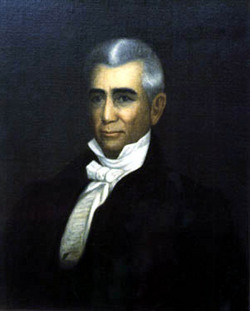
Richard Thomas
| Birth | : | 20 Jun 1797 St. Mary's County, Maryland, USA |
| Death | : | 30 Oct 1849 St. Mary's County, Maryland, USA |
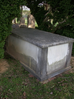
| Burial | : | Rake Lane Cemetery, Wallasey, Metropolitan Borough of Wirral, England |
| Coordinate | : | 53.4256120, -3.0437320 |
| Description | : | St. Mary's Beacon November 1, 1849: Death of Richard Thomas. We deeply regret to announce the death of Hon. Richard Thomas of this county, who died at his residence on Tuesday last. Mr. T., we understand, seemed to be in excellent health in the morning, and started to ride over his farm; he had left the house, however, but a short time when he was found by one of his servants lying in the road, speechless, having apparently been taken suddenly ill and fallen from his horse. He was immediately conveyed to his house, but survived only a few hours. Mr. Thomas... Read More |
frequently asked questions (FAQ):
-
Where is Richard Thomas's memorial?
Richard Thomas's memorial is located at: Rake Lane Cemetery, Wallasey, Metropolitan Borough of Wirral, England.
-
When did Richard Thomas death?
Richard Thomas death on 30 Oct 1849 in St. Mary's County, Maryland, USA
-
Where are the coordinates of the Richard Thomas's memorial?
Latitude: 53.4256120
Longitude: -3.0437320
Family Members:
Parent

Siblings
Children
Flowers:


Nearby Cemetories:
1. Rake Lane Cemetery
Wallasey, Metropolitan Borough of Wirral, England
Coordinate: 53.4256120, -3.0437320
2. St Alban's Catholic Church
Wallasey, Metropolitan Borough of Wirral, England
Coordinate: 53.4181339, -3.0445808
3. St Hilary Churchyard
Wallasey, Metropolitan Borough of Wirral, England
Coordinate: 53.4216480, -3.0601780
4. St. John the Evangelist Churchyard
Egremont, Metropolitan Borough of Wirral, England
Coordinate: 53.4163500, -3.0329700
5. St Oswald's Churchyard
Bidston, Metropolitan Borough of Wirral, England
Coordinate: 53.4043400, -3.0791000
6. Flaybrick Memorial Gardens
Birkenhead, Metropolitan Borough of Wirral, England
Coordinate: 53.3968130, -3.0633240
7. Liverpool Naval Memorial
Liverpool, Metropolitan Borough of Liverpool, England
Coordinate: 53.4061220, -2.9981050
8. St Martin-in-the-Fields Churchyard
Liverpool, Metropolitan Borough of Liverpool, England
Coordinate: 53.4210110, -2.9877860
9. St. Alexander Church
Bootle, Metropolitan Borough of Sefton, England
Coordinate: 53.4401090, -2.9922250
10. St. Nicholas' Churchyard
Liverpool, Metropolitan Borough of Liverpool, England
Coordinate: 53.4069350, -2.9951480
11. St. Paul's Churchyard
Liverpool, Metropolitan Borough of Liverpool, England
Coordinate: 53.4099460, -2.9919370
12. St. Mary's Churchyard
Bootle, Metropolitan Borough of Sefton, England
Coordinate: 53.4492620, -3.0006520
13. St. Anthony's Churchyard
Liverpool, Metropolitan Borough of Liverpool, England
Coordinate: 53.4223190, -2.9815350
14. St. George's Churchyard
Liverpool, Metropolitan Borough of Liverpool, England
Coordinate: 53.4049700, -2.9901030
15. St. Werburgh & St. Laurence Catholic Churchyard
Birkenhead, Metropolitan Borough of Wirral, England
Coordinate: 53.3894910, -3.0217530
16. Kirkdale Goal Cemetery
Kirkdale, Metropolitan Borough of Liverpool, England
Coordinate: 53.4361110, -2.9802780
17. St. Anne's Churchyard
Liverpool, Metropolitan Borough of Liverpool, England
Coordinate: 53.4149050, -2.9782840
18. St. Peter's Churchyard
Liverpool, Metropolitan Borough of Liverpool, England
Coordinate: 53.4051290, -2.9844200
19. Friends Burial Ground (Defunct)
Liverpool, Metropolitan Borough of Liverpool, England
Coordinate: 53.4111670, -2.9795830
20. St. Mary's Churchyard
Birkenhead, Metropolitan Borough of Wirral, England
Coordinate: 53.3895930, -3.0112520
21. St. John's Garden
Liverpool, Metropolitan Borough of Liverpool, England
Coordinate: 53.4087890, -2.9810070
22. St. Mary's Cemetery
Kirkdale, Metropolitan Borough of Liverpool, England
Coordinate: 53.4323690, -2.9752500
23. St. Thomas Churchyard
Liverpool, Metropolitan Borough of Liverpool, England
Coordinate: 53.4010330, -2.9861190
24. Holy Trinity Churchyard
Liverpool, Metropolitan Borough of Liverpool, England
Coordinate: 53.4117490, -2.9759560