

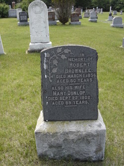
Robert Brownlie
| Birth | : | 12 Jun 1805 South Lanarkshire, Scotland |
| Death | : | 1 Mar 1856 Dalhousie Lake, Lanark County, Ontario, Canada |
| Burial | : | New Delmer Cemetery, Delmer, Oxford County Municipality, Canada |
| Coordinate | : | 42.8668600, -80.7941200 |
| Plot | : | 122 |
| Description | : | Came to Canada in 1826 with parents James Brownlee and Margaret Thomson to Kingston. The family lived in Kingston for two years before moving to Dalhousie Twp. in 1828. Robert settled on a farm at Con 12, Lot 10E of Dalhousie Twp. The farm was located on the north side of the John Crawford farm and the newer section of Crawford's Cemetery is located on the original Robert and Mary Brownlee farm. In the late 1890s the farm was sold to Andrew Paul and then then passed onto to his son Robert Paul. Robert Brownlee farmed there until his... Read More |
frequently asked questions (FAQ):
-
Where is Robert Brownlie's memorial?
Robert Brownlie's memorial is located at: New Delmer Cemetery, Delmer, Oxford County Municipality, Canada.
-
When did Robert Brownlie death?
Robert Brownlie death on 1 Mar 1856 in Dalhousie Lake, Lanark County, Ontario, Canada
-
Where are the coordinates of the Robert Brownlie's memorial?
Latitude: 42.8668600
Longitude: -80.7941200
Family Members:
Parent
Spouse
Siblings

Children
Flowers:


Nearby Cemetories:
1. New Delmer Cemetery
Delmer, Oxford County Municipality, Canada
Coordinate: 42.8668600, -80.7941200
2. Old Delmer Cemetery
Delmer, Oxford County Municipality, Canada
Coordinate: 42.8697900, -80.7966000
3. Eden Cemetery
Eden, Elgin County, Canada
Coordinate: 42.8345448, -80.7845962
4. Best Cemetery
Corinth, Elgin County, Canada
Coordinate: 42.8208389, -80.8180084
5. Tillsonburg Pioneer Cemetery
Tillsonburg, Oxford County Municipality, Canada
Coordinate: 42.8597300, -80.7154500
6. Saint Mary's Roman Catholic Cemetery
Tillsonburg, Oxford County Municipality, Canada
Coordinate: 42.8552200, -80.7072600
7. Tillsonburg Cemetery
Tillsonburg, Oxford County Municipality, Canada
Coordinate: 42.8559265, -80.7041931
8. Saint Charles Anglican Cemetery
Tillsonburg, Oxford County Municipality, Canada
Coordinate: 42.9089127, -80.7220459
9. Firby Cemetery
North Hall, Elgin County, Canada
Coordinate: 42.8048172, -80.8567123
10. Dobbie Cemetery
Bayham, Elgin County, Canada
Coordinate: 42.7938257, -80.7532762
11. New Road Cemetery
Rock's Mills, Oxford County Municipality, Canada
Coordinate: 42.8870300, -80.6899700
12. Springfield Cemetery
Springfield, Elgin County, Canada
Coordinate: 42.8295400, -80.8890500
13. Rosanna Cemetery
Rock's Mills, Oxford County Municipality, Canada
Coordinate: 42.8867683, -80.6898270
14. Scoffin Burying Ground
Malahide, Elgin County, Canada
Coordinate: 42.9072600, -80.8975830
15. Sandy Ridge Pet Cemetery
Eden, Elgin County, Canada
Coordinate: 42.7843400, -80.7476900
16. Old Eden Cemetery
Eden, Elgin County, Canada
Coordinate: 42.7846900, -80.7455500
17. Mount Elgin Cemetery
Mount Elgin, Oxford County Municipality, Canada
Coordinate: 42.9581400, -80.7961000
18. Ketchabaw Cemetery
Straffordville, Elgin County, Canada
Coordinate: 42.7706020, -80.7774500
19. North Middleton Baptist Acacia Cemetery
Norfolk County, Canada
Coordinate: 42.7908760, -80.7037660
20. Trinity Cemetery
Seville, Elgin County, Canada
Coordinate: 42.7931330, -80.8973120
21. Ebenezer Grove Cemetery
Mount Elgin, Oxford County Municipality, Canada
Coordinate: 42.9633100, -80.8577100
22. Richmond West Cemetery
Bayham, Elgin County, Canada
Coordinate: 42.7667240, -80.8481180
23. Amish Mennonite Aylmer Cemetery
Springfield, Elgin County, Canada
Coordinate: 42.7959010, -80.9071210
24. Old Colony Mennonite Cemetery
Aylmer, Elgin County, Canada
Coordinate: 42.7929230, -80.9045886