
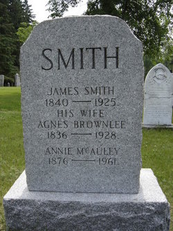
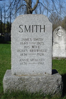
Agnes Brownlee Smith
| Birth | : | 1 Sep 1836 |
| Death | : | 11 Jun 1928 |
| Burial | : | Cedar Grove Cemetery, Henderson County, USA |
| Coordinate | : | 35.4799600, -88.2678900 |
| Plot | : | 40 |
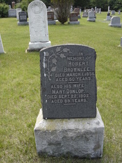
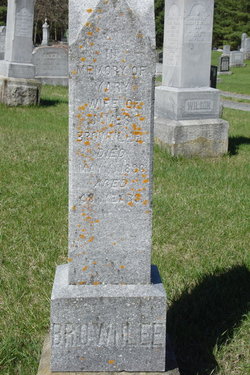
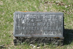
| Description | : | Daughter of Robert Brownlee & Mary Dunlop. Wife of James Smith. -------------------------------- Plot 40 : - James Smith 1840-1925. - his wife, Agnes Brownlee 1836-1928. - Annie McAuley Smith 1876-1961. -------------------------------- Death - The Lanark Era - June 20,1928 - Elphin, ON, Mon. June 11th, 1928, Agnes Brownlee, widow of James Smith Sr. who died Jan. 6th, 1925. She was born Sept. 1st, 1836, the second eldest in a family of nine of Robert Brownlee and his wife, Mary Dunlop. She married on May 30th, 1873 to James Smith and they had two children; James B. and Annie M., both at home. There are also two sisters yet living,... Read More |
frequently asked questions (FAQ):
-
Where is Agnes Brownlee Smith's memorial?
Agnes Brownlee Smith's memorial is located at: Cedar Grove Cemetery, Henderson County, USA.
-
When did Agnes Brownlee Smith death?
Agnes Brownlee Smith death on 11 Jun 1928 in
-
Where are the coordinates of the Agnes Brownlee Smith's memorial?
Latitude: 35.4799600
Longitude: -88.2678900
Family Members:
Parent

Spouse
Siblings

Children
Flowers:


Nearby Cemetories:
1. Cedar Grove Cemetery
Henderson County, USA
Coordinate: 35.4799600, -88.2678900
2. Cedar Grove Pentecostal Cemetery
Sardis, Henderson County, USA
Coordinate: 35.4829530, -88.2698440
3. Granny Austin Cemetery
Scotts Hill, Henderson County, USA
Coordinate: 35.4949850, -88.2734300
4. Fellowship Church Cemetery
Scotts Hill, Henderson County, USA
Coordinate: 35.4965940, -88.2602540
5. Doe Creek Cemetery
Scotts Hill, Henderson County, USA
Coordinate: 35.4692990, -88.2474350
6. Prospect Church Cemetery
Sardis, Henderson County, USA
Coordinate: 35.4584950, -88.2683120
7. Pleasant View Cemetery
Sardis, Henderson County, USA
Coordinate: 35.4639730, -88.3019970
8. Bethel Cemetery
Scotts Hill, Decatur County, USA
Coordinate: 35.4963690, -88.2320790
9. Lowery-Doe Creek Cemetery
Decatur County, USA
Coordinate: 35.4483120, -88.2468900
10. Grandsire Holmes Cemetery
Scotts Hill, Henderson County, USA
Coordinate: 35.5140820, -88.2483620
11. Scotts Hill Pentecostal Church Cemetery
Scotts Hill, Decatur County, USA
Coordinate: 35.5065610, -88.2336080
12. Scotts Hill Church Cemetery
Scotts Hill, Henderson County, USA
Coordinate: 35.5189480, -88.2463960
13. Sardis Cemetery
Sardis, Henderson County, USA
Coordinate: 35.4366020, -88.2833100
14. Pafford - Scotts Hill Cemetery
Scotts Hill, Henderson County, USA
Coordinate: 35.5265450, -88.2515290
15. McBride Cemetery
Sardis, Henderson County, USA
Coordinate: 35.4406013, -88.3106003
16. Little Hurricane Cemetery
Sardis, Henderson County, USA
Coordinate: 35.4605060, -88.3302360
17. Liberty Church Cemetery
Scotts Hill, Decatur County, USA
Coordinate: 35.4466050, -88.2146570
18. Peace Chapel Cemetery
Scotts Hill, Decatur County, USA
Coordinate: 35.5214060, -88.2206280
19. Murphy Cemetery
Lick Skillet, Decatur County, USA
Coordinate: 35.4806930, -88.1983720
20. Ebenezer Cemetery
Henderson County, USA
Coordinate: 35.5353940, -88.2887670
21. Spring Hill Cemetery
Sardis, Henderson County, USA
Coordinate: 35.4277992, -88.3091965
22. Chumney Cemetery
Scotts Hill, Henderson County, USA
Coordinate: 35.5423140, -88.2460590
23. Decatur County Farm Cemetery
Scotts Hill, Decatur County, USA
Coordinate: 35.5078697, -88.1940994
24. Ridley Chapel Cemetery
Reagan, Henderson County, USA
Coordinate: 35.5026110, -88.3454170