
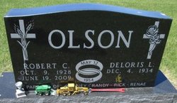
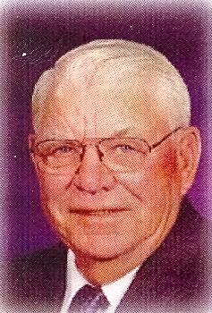
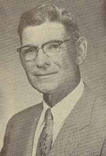
Robert Clayton “Bob” Olson
| Birth | : | 9 Oct 1928 Lake Preston, Kingsbury County, South Dakota, USA |
| Death | : | 19 Jun 2009 De Smet, Kingsbury County, South Dakota, USA |
| Burial | : | Grantville Cemetery, Grantville, Bass Coast Shire, Australia |
| Coordinate | : | -38.3947460, 145.5398240 |
| Description | : | ROBERT CLAYTON OLSON was born October 9, 1928, to parents John and Teressa (Jensen) Olson on a farm near Lake Preston, SO. He grew up and attended country school in the Lake Preston area. He was baptized and confirmed at North Preston Lutheran Church. Robert entered the US Army November 30, 1951. He served in Korea with the 5th Regimental Combat Team and was honorably discharged on August 29, 1953. He was united in marriage to Deloris Nielsen on May 12, 1954, at Pipestone, MN. To this union four children were born. He worked for many years in... Read More |
frequently asked questions (FAQ):
-
Where is Robert Clayton “Bob” Olson's memorial?
Robert Clayton “Bob” Olson's memorial is located at: Grantville Cemetery, Grantville, Bass Coast Shire, Australia.
-
When did Robert Clayton “Bob” Olson death?
Robert Clayton “Bob” Olson death on 19 Jun 2009 in De Smet, Kingsbury County, South Dakota, USA
-
Where are the coordinates of the Robert Clayton “Bob” Olson's memorial?
Latitude: -38.3947460
Longitude: 145.5398240
Family Members:
Parent
Spouse
Siblings

Flowers:


Nearby Cemetories:
1. Grantville Cemetery
Grantville, Bass Coast Shire, Australia
Coordinate: -38.3947460, 145.5398240
2. Corinella Cemetery
Corinella, Bass Coast Shire, Australia
Coordinate: -38.4361780, 145.4847240
3. Nyora Cemetery
Nyora, South Gippsland Shire, Australia
Coordinate: -38.3406970, 145.6637270
4. Lang Lang Cemetery
Lang Lang, Cardinia Shire, Australia
Coordinate: -38.2779980, 145.5831970
5. Kilcunda Cemetery
Kilcunda, Bass Coast Shire, Australia
Coordinate: -38.5590700, 145.4918990
6. Poowong Cemetery
Poowong, South Gippsland Shire, Australia
Coordinate: -38.3461002, 145.7615830
7. San Remo Cemetery
San Remo, Bass Coast Shire, Australia
Coordinate: -38.5264220, 145.3794970
8. San Remo Fisherman Lost at Sea
San Remo, Bass Coast Shire, Australia
Coordinate: -38.5204271, 145.3646088
9. Outtrim Cemetery
Outtrim, South Gippsland Shire, Australia
Coordinate: -38.5122130, 145.7768440
10. Tooradin Christ Church Memorial Garden
Tooradin, Casey City, Australia
Coordinate: -38.2109390, 145.3781320
11. Wonthaggi Cemetery
Wonthaggi, Bass Coast Shire, Australia
Coordinate: -38.6211128, 145.5833282
12. Phillip Island Cemetery
Cowes, Bass Coast Shire, Australia
Coordinate: -38.4703860, 145.2578930
13. Coal Creek Community Park and Museum
Korumburra, South Gippsland Shire, Australia
Coordinate: -38.4438019, 145.8312988
14. Korumburra Cemetery
Korumburra, South Gippsland Shire, Australia
Coordinate: -38.4303000, 145.8482100
15. Ripplebrook Cemetery
Drouin South, Baw Baw Shire, Australia
Coordinate: -38.2074990, 145.7508310
16. Hmas Cerberus Cemetery
Crib Point, Mornington Peninsula Shire, Australia
Coordinate: -38.3740200, 145.2103850
17. Tyabb Cemetery
Hastings, Mornington Peninsula Shire, Australia
Coordinate: -38.3029320, 145.2141720
18. Inverloch Cemetery
Inverloch, Bass Coast Shire, Australia
Coordinate: -38.6273780, 145.7185850
19. Crib Point Cemetery
Crib Point, Mornington Peninsula Shire, Australia
Coordinate: -38.3540390, 145.1879580
20. Captain Grossard Lone Grave
Ventnor, Bass Coast Shire, Australia
Coordinate: -38.4625830, 145.1785719
21. Leongatha Cemetery
Leongatha, South Gippsland Shire, Australia
Coordinate: -38.4831187, 145.9380932
22. Bunyip Cemetery
Bunyip, Cardinia Shire, Australia
Coordinate: -38.0838160, 145.7169040
23. Pakenham Cemetery
Pakenham, Cardinia Shire, Australia
Coordinate: -38.0561540, 145.4513150
24. Cranbourne Cemetery
Cranbourne, Casey City, Australia
Coordinate: -38.1118510, 145.2728020