
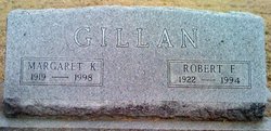

Robert Franklin “Bud” Gillan
| Birth | : | 20 Feb 1922 Exeter, Fillmore County, Nebraska, USA |
| Death | : | 7 Apr 1994 Concordia, Cloud County, Kansas, USA |
| Burial | : | Belfast Cemetery, Belfast, Christchurch City, New Zealand |
| Coordinate | : | -43.4532460, 172.6424400 |
| Description | : | Robert Franklin Gillan Robert F. Gillan, 72, Concordia, died April 7, 1994 at St. Joseph Hospital. He was born Feb. 20, 1922 at Exeter, Neb., to Olen and Edna Gillan. A year later the family the family moved to Concordia. He was raised there and graduated from Concordia High School. During World War II Mr. Gillan severed in the Army Air Corps and was stationed at several bases in the states and in Trinidad. He attended and graduated from Kansas State University in 1950 and in February 1951 he married Deloras Dodson. He was employed... Read More |
frequently asked questions (FAQ):
-
Where is Robert Franklin “Bud” Gillan's memorial?
Robert Franklin “Bud” Gillan's memorial is located at: Belfast Cemetery, Belfast, Christchurch City, New Zealand.
-
When did Robert Franklin “Bud” Gillan death?
Robert Franklin “Bud” Gillan death on 7 Apr 1994 in Concordia, Cloud County, Kansas, USA
-
Where are the coordinates of the Robert Franklin “Bud” Gillan's memorial?
Latitude: -43.4532460
Longitude: 172.6424400
Family Members:
Parent

Spouse

Siblings
Flowers:


Nearby Cemetories:
1. Belfast Cemetery
Belfast, Christchurch City, New Zealand
Coordinate: -43.4532460, 172.6424400
2. Harewood Memorial Gardens & Crematorium
Harewood, Christchurch City, New Zealand
Coordinate: -43.4642810, 172.5845430
3. St Augustine’s Anglican Cemetery
Clarkville, Waimakariri District, New Zealand
Coordinate: -43.4055600, 172.6284700
4. St Paul's Anglican Church Cemetery
Papanui, Christchurch City, New Zealand
Coordinate: -43.4966540, 172.6067210
5. All Saints Church Cemetery
Burwood, Christchurch City, New Zealand
Coordinate: -43.4999650, 172.6865820
6. Kaiapoi Anglican Cemetery
Kaiapoi, Waimakariri District, New Zealand
Coordinate: -43.3909700, 172.6510500
7. Waimairi Cemetery
Burnside, Christchurch City, New Zealand
Coordinate: -43.4997760, 172.5773860
8. St James Anglican Church
Harewood, Christchurch City, New Zealand
Coordinate: -43.4788400, 172.5579800
9. Barbadoes Street Cemetery
Christchurch, Christchurch City, New Zealand
Coordinate: -43.5230370, 172.6458760
10. Avonside Anglican Cemetery
Avonside, Christchurch City, New Zealand
Coordinate: -43.5265780, 172.6585100
11. Eyreton St Thomas' Anglican Cemetery
Swannanoa, Waimakariri District, New Zealand
Coordinate: -43.4153900, 172.5508800
12. Kaiapoi Public Cemetery
Kaiapoi, Waimakariri District, New Zealand
Coordinate: -43.3761690, 172.6364140
13. Linwood Cemetery
Linwood, Christchurch City, New Zealand
Coordinate: -43.5299220, 172.6828180
14. Memorial Park Cemetery
Bromley, Christchurch City, New Zealand
Coordinate: -43.5291840, 172.6877410
15. Blessed Sacrament Cathedral
Christchurch, Christchurch City, New Zealand
Coordinate: -43.5384250, 172.6458880
16. Ruru Lawn Cemetery
Bromley, Christchurch City, New Zealand
Coordinate: -43.5322470, 172.6918010
17. Canterbury Provincial Memorial
Bromley, Christchurch City, New Zealand
Coordinate: -43.5329620, 172.6896830
18. Avonhead Memorial Cemetery
Avonhead, Christchurch City, New Zealand
Coordinate: -43.5095390, 172.5503920
19. Bromley Cemetery
Bromley, Christchurch City, New Zealand
Coordinate: -43.5384980, 172.6862960
20. Addington Cemetery
Addington, Christchurch City, New Zealand
Coordinate: -43.5434880, 172.6235790
21. St Peter's Anglican Churchyard
Upper Riccarton, Christchurch City, New Zealand
Coordinate: -43.5317570, 172.5701330
22. Te Kai a te Atua Urupā
Kaiapoi, Waimakariri District, New Zealand
Coordinate: -43.3595600, 172.6610100
23. Canterbury Memorial Gardens and Crematorium
Bromley, Christchurch City, New Zealand
Coordinate: -43.5420790, 172.6893340
24. St. Paul's Church Cemetery
Flaxton, Waimakariri District, New Zealand
Coordinate: -43.3593380, 172.6065530