

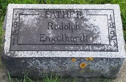
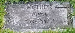
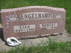
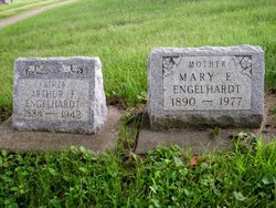
Robert Henry Engelhardt
| Birth | : | 13 Dec 1886 |
| Death | : | 2 May 1958 Prairie du Chien, Crawford County, Wisconsin, USA |
| Burial | : | Elkader Cemetery, Elkader, Clayton County, USA |
| Coordinate | : | 42.8541718, -91.4000015 |
| Description | : | Dubuque Telegraph Herald Sunday 04 May 1958 ELKADER, Ia. — Robert Englehardt, 71, retired farmer, died Friday at a Prairie du Chien, Wis. hospital. Services will be at 2 p m Monday at th e Evangelical & Reformed Church here, and burial will be in East Side Cemetery. Friends may call at Witt Funeral Home. Mr. Englehardt leaves his wife; two sons, Curtis and Allan, both of Elkader; two brothers, John of Monona and Louis of Luana; and a sister, Mrs. Alma Oelke, Mitchell, S.D. |
frequently asked questions (FAQ):
-
Where is Robert Henry Engelhardt's memorial?
Robert Henry Engelhardt's memorial is located at: Elkader Cemetery, Elkader, Clayton County, USA.
-
When did Robert Henry Engelhardt death?
Robert Henry Engelhardt death on 2 May 1958 in Prairie du Chien, Crawford County, Wisconsin, USA
-
Where are the coordinates of the Robert Henry Engelhardt's memorial?
Latitude: 42.8541718
Longitude: -91.4000015
Family Members:
Parent
Spouse
Siblings

Flowers:


Nearby Cemetories:
1. Elkader Cemetery
Elkader, Clayton County, USA
Coordinate: 42.8541718, -91.4000015
2. Saint Josephs Cemetery
Elkader, Clayton County, USA
Coordinate: 42.8488998, -91.4021988
3. Hartman Cemetery
Cox Creek Township, Clayton County, USA
Coordinate: 42.8155360, -91.3880840
4. Colony Catholic Cemetery (Defunct)
Read Township, Clayton County, USA
Coordinate: 42.8830000, -91.3580000
5. County Home Cemetery
Clayton Center, Clayton County, USA
Coordinate: 42.8916702, -91.3499985
6. Dohrer Cemetery
Osborne, Clayton County, USA
Coordinate: 42.8124846, -91.4584734
7. Meenan Cemetery
Communia, Clayton County, USA
Coordinate: 42.7999862, -91.3584693
8. Zion Lutheran Cemetery
Clayton Center, Clayton County, USA
Coordinate: 42.8841705, -91.3249969
9. Cords Cemetery
Osborne, Clayton County, USA
Coordinate: 42.7973308, -91.4377662
10. Clayton Center Cemetery
Clayton Center, Clayton County, USA
Coordinate: 42.8841705, -91.3225021
11. Communia Cemetery
Volga Township, Clayton County, USA
Coordinate: 42.7868996, -91.3630981
12. Patterson Pioneer Cemetery
Saint Olaf, Clayton County, USA
Coordinate: 42.9216000, -91.4489000
13. Watkins Cemetery
Osborne, Clayton County, USA
Coordinate: 42.7833180, -91.4584733
14. Clark Family Cemetery
Beulah, Clayton County, USA
Coordinate: 42.9166505, -91.4751415
15. Norway Lutheran Church Cemetery
Saint Olaf, Clayton County, USA
Coordinate: 42.9352798, -91.4302826
16. Weymouth Cemetery
Saint Olaf, Clayton County, USA
Coordinate: 42.9278799, -91.4583559
17. Mederville Cemetery
Elkader, Clayton County, USA
Coordinate: 42.7638893, -91.4194412
18. Krumm Cemetery
Garber, Clayton County, USA
Coordinate: 42.7913760, -91.3023559
19. Farmersburg-Wagner Cemetery
Farmersburg, Clayton County, USA
Coordinate: 42.9481010, -91.3700027
20. Blanchaine Cemetery
Volga, Clayton County, USA
Coordinate: 42.7676210, -91.3389040
21. Cook Family Cemetery
Elkader, Clayton County, USA
Coordinate: 42.9209880, -91.5091230
22. Wagner Township Cemetery
Saint Olaf, Clayton County, USA
Coordinate: 42.9519386, -91.4513931
23. Eberhard Cemetery
Littleport, Clayton County, USA
Coordinate: 42.7583201, -91.3418020
24. Highland Lutheran Cemetery
Highland Township, Clayton County, USA
Coordinate: 42.8987000, -91.5330000