
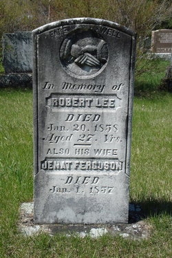
Robert Lee
| Birth | : | 1829 |
| Death | : | 20 Jan 1858 |
| Burial | : | St Mary the Virgin, Burton Latimer, Kettering Borough, England |
| Coordinate | : | 52.3659000, -0.6751170 |
| Plot | : | 176 |
| Description | : | Plot 176 : - In memory of, - Robert Lee, died Jan.20,1858, aged 27 yrs. - also his wife, Janet Ferguson, died Jan.1,1857. |
frequently asked questions (FAQ):
-
Where is Robert Lee's memorial?
Robert Lee's memorial is located at: St Mary the Virgin, Burton Latimer, Kettering Borough, England.
-
When did Robert Lee death?
Robert Lee death on 20 Jan 1858 in
-
Where are the coordinates of the Robert Lee's memorial?
Latitude: 52.3659000
Longitude: -0.6751170
Family Members:
Parent
Spouse

Siblings
Flowers:


Nearby Cemetories:
1. St Mary the Virgin
Burton Latimer, Kettering Borough, England
Coordinate: 52.3659000, -0.6751170
2. Burton Latimer Parish Council Cemetery
Burton Latimer, Kettering Borough, England
Coordinate: 52.3649700, -0.6738600
3. Burton Latimer Cemetery
Burton Latimer, Kettering Borough, England
Coordinate: 52.3642100, -0.6733200
4. Baptist Church
Burton Latimer, Kettering Borough, England
Coordinate: 52.3642183, -0.6773429
5. Saint Peter
Isham, Wellingborough Borough, England
Coordinate: 52.3563320, -0.7021160
6. Isham Cemetery
Isham, Wellingborough Borough, England
Coordinate: 52.3597000, -0.7056800
7. St Botolph Churchyard
Barton Seagrave, Kettering Borough, England
Coordinate: 52.3846400, -0.6961900
8. Finedon
Finedon, Wellingborough Borough, England
Coordinate: 52.3407999, -0.6648562
9. St. Andrew's Churchyard
Cranford, Kettering Borough, England
Coordinate: 52.3856700, -0.6438700
10. St. John's Churchyard
Cranford St John, Kettering Borough, England
Coordinate: 52.3840560, -0.6391670
11. Saint Mary the Virgin Churchyard Extension
Finedon, Wellingborough Borough, England
Coordinate: 52.3385489, -0.6613748
12. All Saints Churchyard
Brixworth, Daventry District, England
Coordinate: 52.3835815, -0.7309842
13. All Saints Churchyard
Pytchley, Kettering Borough, England
Coordinate: 52.3641220, -0.7384500
14. St Mary the Virgin
Little Harrowden, Wellingborough Borough, England
Coordinate: 52.3362282, -0.7223209
15. London Road Cemetery
Kettering, Kettering Borough, England
Coordinate: 52.3956500, -0.7241100
16. All Saints Churchyard
Great Harrowden, Wellingborough Borough, England
Coordinate: 52.3286800, -0.7096600
17. St Edmund Churchyard
Warkton, Kettering Borough, England
Coordinate: 52.4091701, -0.6884724
18. Saint Peter and Saint Paul Churchyard
Kettering, Kettering Borough, England
Coordinate: 52.3969000, -0.7266000
19. St. Mary's Churchyard
Orlingbury, Wellingborough Borough, England
Coordinate: 52.3426000, -0.7397000
20. St. James the Apostle Churchyard
Grafton Underwood, Kettering Borough, England
Coordinate: 52.4108323, -0.6449725
21. All Saints Churchyard
Great Addington, East Northamptonshire Borough, England
Coordinate: 52.3657660, -0.5937010
22. St. Nicholas' Churchyard
Twywell, East Northamptonshire Borough, England
Coordinate: 52.3936001, -0.6024166
23. St Mary the Virgin Churchyard
Weekley, Kettering Borough, England
Coordinate: 52.4196890, -0.6952190
24. New Irthlingborough Cemetery
Irthlingborough, East Northamptonshire Borough, England
Coordinate: 52.3178531, -0.6294229