Robert LeRoy “Bob” Burns
| Birth | : | 18 Sep 1925 Cherokee, Cherokee County, Iowa, USA |
| Death | : | 10 Aug 2009 Prescott, Yavapai County, Arizona, USA |
| Burial | : | Kaikoura Public Cemetery, Kaikōura, Kaikoura District, New Zealand |
| Coordinate | : | -42.4105400, 173.6797300 |
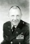
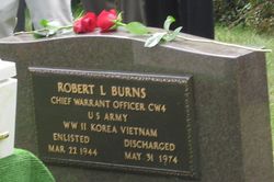
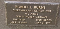
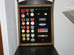
| Description | : | Robert L. (Bob) Burns of Prescott passed away on August 10th, 2009, at the age of 83. He was born September 18, 1925 in Cherokee, Iowa. During his early childhood, his family lived near Washta, Iowa, where his remains will be interred. He attended schools in Washta and Buckhorn, Missouri and was a graduate of Wilson High School in Cherokee. He received an AA degree from Mount SAC in Walnut, California. Robert entered the US Army on March 22, 1944 and remained in the Army for 30 years. He served in World War II, the Korean War and twice in... Read More |
frequently asked questions (FAQ):
-
Where is Robert LeRoy “Bob” Burns's memorial?
Robert LeRoy “Bob” Burns's memorial is located at: Kaikoura Public Cemetery, Kaikōura, Kaikoura District, New Zealand.
-
When did Robert LeRoy “Bob” Burns death?
Robert LeRoy “Bob” Burns death on 10 Aug 2009 in Prescott, Yavapai County, Arizona, USA
-
Where are the coordinates of the Robert LeRoy “Bob” Burns's memorial?
Latitude: -42.4105400
Longitude: 173.6797300
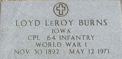
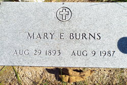
Family Members:
Parent
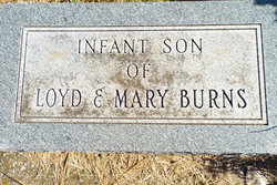
Siblings
Flowers:
Nearby Cemetories:
1. Kaikoura Public Cemetery
Kaikōura, Kaikoura District, New Zealand
Coordinate: -42.4105400, 173.6797300
2. St. James Anglican Churchyard
Kaikōura, Kaikoura District, New Zealand
Coordinate: -42.3791350, 173.6321660
3. Hapuku Urupā
Hapuku, Kaikoura District, New Zealand
Coordinate: -42.3124300, 173.7506600
4. Whalers Grave
Oaro, Kaikoura District, New Zealand
Coordinate: -42.5340691, 173.5026990
5. Rangi Gill's Gravesite
Molesworth, Marlborough District, New Zealand
Coordinate: -42.1379353, 173.1600656
6. St. George Church Churchyard
Kekerengu, Kaikoura District, New Zealand
Coordinate: -42.0000264, 174.0013961
7. Homeview Cemetery
Cheviot, Hurunui District, New Zealand
Coordinate: -42.7939600, 173.2701100
8. Jed River Cemetery
Hurunui District, New Zealand
Coordinate: -42.8480000, 173.3133270
9. Waiau Cemetery
Waiau, Hurunui District, New Zealand
Coordinate: -42.6547350, 173.0465200
10. Red Gate Hut Graves
Molesworth, Marlborough District, New Zealand
Coordinate: -42.1325380, 173.0534620
11. Sammy Palmer's Grave
Wharanui, Marlborough District, New Zealand
Coordinate: -41.9065258, 174.0104896
12. Saint Oswald's Churchyard
Wharanui, Marlborough District, New Zealand
Coordinate: -41.9287622, 174.0855260
13. Rotherham Cemetery
Rotherham, Hurunui District, New Zealand
Coordinate: -42.6948170, 172.9572170
14. Hanmer Springs Cemetery
Hanmer Springs, Hurunui District, New Zealand
Coordinate: -42.5175400, 172.8632300
15. Altimarlock Station
Altimarlock, Marlborough District, New Zealand
Coordinate: -41.7387595, 173.8579141
16. Ward Flaxbourne Cemetery
Ward, Marlborough District, New Zealand
Coordinate: -41.8164648, 174.1400507
17. Old Flaxbourne Graveyard
Ward, Marlborough District, New Zealand
Coordinate: -41.8335228, 174.1781740
18. Culverden Cemetery
Culverden, Hurunui District, New Zealand
Coordinate: -42.7704060, 172.8366990
19. Fidèle Crew Graves
Ward, Marlborough District, New Zealand
Coordinate: -41.7834471, 174.2287789
20. Taylor Pass Cemetery
Seddon, Marlborough District, New Zealand
Coordinate: -41.6706624, 173.9871644
21. Seddon Cemetery
Seddon, Marlborough District, New Zealand
Coordinate: -41.6831810, 174.0582210
22. Cape Campbell Lighthouse Burial Site
Marlborough District, New Zealand
Coordinate: -41.7316008, 174.2731993
23. Lansdowne Cemetery
Hillersden, Marlborough District, New Zealand
Coordinate: -41.5709846, 173.5434728
24. Wairau Valley Catholic Cemetery
Wairau Valley, Marlborough District, New Zealand
Coordinate: -41.5617282, 173.5383700

