
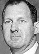
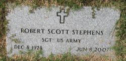
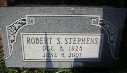
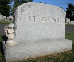
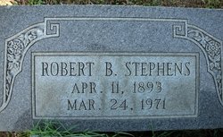
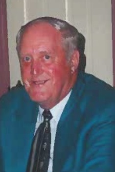
Robert Scott Stephens
| Birth | : | 8 Dec 1928 Pennsylvania, USA |
| Death | : | 8 Jun 2007 Fredericksburg City, Virginia, USA |
| Burial | : | Holy Trinity Churchyard, Thrussington, Charnwood Borough, England |
| Coordinate | : | 52.7359030, -1.0381780 |
| Description | : | Robert Scott "Bobby" Stephens, 78, of Fredericksburg Virginia passed away peacefully Friday June 8, 2007, at his home. He is survived by his wife of 49 years, Oneida Stiles Stephens. From this union, they shared three children, Mark Leigh Stephens, and wife Barbara of Stafford, Jennifer Gray Stephens of Fredericksburg, and Cynthia Ann Snellings, and husband Walter of Spotsylvania; five grandchildren, Elizabeth D. Benshoff, Jennifer N. Stephens, Candice M. Benshoff, R. Logan Benshoff, and Dawson J. Fishel. He is also survived by two brothers, Ollie King Stephens and Aubrey E. Trigg, and wife Debbie of Fredericksburg, and four nephews; David K.... Read More |
frequently asked questions (FAQ):
-
Where is Robert Scott Stephens's memorial?
Robert Scott Stephens's memorial is located at: Holy Trinity Churchyard, Thrussington, Charnwood Borough, England.
-
When did Robert Scott Stephens death?
Robert Scott Stephens death on 8 Jun 2007 in Fredericksburg City, Virginia, USA
-
Where are the coordinates of the Robert Scott Stephens's memorial?
Latitude: 52.7359030
Longitude: -1.0381780
Family Members:
Parent
Siblings


Nearby Cemetories:
1. Holy Trinity Churchyard
Thrussington, Charnwood Borough, England
Coordinate: 52.7359030, -1.0381780
2. St Michael and All Angels Churchyard
Rearsby, Charnwood Borough, England
Coordinate: 52.7255100, -1.0373500
3. St Michael and All Angels Churchyard, Brooksby Hall
Melton Mowbray, Melton Borough, England
Coordinate: 52.7375450, -1.0076900
4. St Botolphs Churchyard
Ratcliffe on the Wreake, Charnwood Borough, England
Coordinate: 52.7248680, -1.0680400
5. All Saints Churchyard
Hoby, Melton Borough, England
Coordinate: 52.7496100, -1.0101660
6. All Saints Churchyard
Rotherby, Melton Borough, England
Coordinate: 52.7423100, -1.0013400
7. Ratcliffe College
Ratcliffe on the Wreake, Charnwood Borough, England
Coordinate: 52.7294430, -1.0758320
8. All Saints Churchyard
Seagrave, Charnwood Borough, England
Coordinate: 52.7525110, -1.0829090
9. St Mary Churchyard
Queniborough, Charnwood Borough, England
Coordinate: 52.7023900, -1.0382700
10. Seagrave Swan Street Cemetery
Seagrave, Charnwood Borough, England
Coordinate: 52.7520370, -1.0883200
11. Queniborough Cemetery
Queniborough, Charnwood Borough, England
Coordinate: 52.7011860, -1.0315250
12. Frisby on the Wreake Parish Council Burial Ground
Frisby on the Wreake, Melton Borough, England
Coordinate: 52.7480480, -0.9801370
13. Sileby Cemetery
Sileby, Charnwood Borough, England
Coordinate: 52.7299340, -1.1004210
14. All Saints Church
Melton Borough, England
Coordinate: 52.7728570, -1.0209240
15. All Saints Churchyard
Melton Mowbray, Melton Borough, England
Coordinate: 52.7728700, -1.0209400
16. Saint Peter & Saint Paul's Churchyard
Syston, Charnwood Borough, England
Coordinate: 52.7007410, -1.0746400
17. Saint Luke's Churchyard
Gaddesby, Melton Borough, England
Coordinate: 52.7107200, -0.9805300
18. St Thomas of Canterbury Churchyard
Frisby on the Wreake, Melton Borough, England
Coordinate: 52.7531250, -0.9706940
19. Syston Cemetery
Syston, Charnwood Borough, England
Coordinate: 52.6951100, -1.0675000
20. St Thomas of Canterbury Churchyard Extension
Frisby on the Wreake, Melton Borough, England
Coordinate: 52.7537270, -0.9698390
21. St. Mary's Churchyard
Sileby, Charnwood Borough, England
Coordinate: 52.7308600, -1.1121420
22. All Saints Churchyard
Cossington, Charnwood Borough, England
Coordinate: 52.7173590, -1.1073300
23. Barkby Cemetery
Barkby, Charnwood Borough, England
Coordinate: 52.6840800, -1.0602200
24. Asfordby Loughborough Road Cemetery
Asfordby, Melton Borough, England
Coordinate: 52.7654300, -0.9626900