
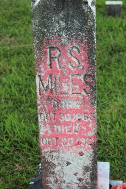
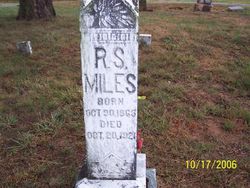
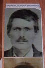
Robert Smith Miles
| Birth | : | 30 Oct 1866 Jackson County, Tennessee, USA |
| Death | : | 20 Oct 1921 Miles Crossroads, Clay County, Tennessee, USA |
| Burial | : | St. John The Baptist Churchyard, Oldham, Metropolitan Borough of Oldham, England |
| Coordinate | : | 53.5424690, -2.0680150 |
| Description | : | Son of John Jackson Miles & Mary Bee (Browning)Miles Shot and killed by Fowler Long over argument about Boundary Line Clay County was not formed until 1880. |
frequently asked questions (FAQ):
-
Where is Robert Smith Miles's memorial?
Robert Smith Miles's memorial is located at: St. John The Baptist Churchyard, Oldham, Metropolitan Borough of Oldham, England.
-
When did Robert Smith Miles death?
Robert Smith Miles death on 20 Oct 1921 in Miles Crossroads, Clay County, Tennessee, USA
-
Where are the coordinates of the Robert Smith Miles's memorial?
Latitude: 53.5424690
Longitude: -2.0680150
Family Members:
Parent
Spouse
Siblings

Children
Flowers:


Nearby Cemetories:
1. St. John The Baptist Churchyard
Oldham, Metropolitan Borough of Oldham, England
Coordinate: 53.5424690, -2.0680150
2. St. John the Baptist Churchyard
Heybridge, Central Coast Council, Australia
Coordinate: 53.5415973, -2.0699727
3. St Thomas'
Oldham, Metropolitan Borough of Oldham, England
Coordinate: 53.5366318, -2.0724053
4. Greenacres Congregational Church
Oldham, Metropolitan Borough of Oldham, England
Coordinate: 53.5455200, -2.0788100
5. Lees Cemetery
Oldham, Metropolitan Borough of Oldham, England
Coordinate: 53.5347540, -2.0739260
6. Greenacres Cemetery
Oldham, Metropolitan Borough of Oldham, England
Coordinate: 53.5455490, -2.0820510
7. Holy Trinity Churchyard
Waterhead, Metropolitan Borough of Oldham, England
Coordinate: 53.5507100, -2.0738400
8. St. Mary Church of England Churchyard
Oldham, Metropolitan Borough of Oldham, England
Coordinate: 53.5428030, -2.1104030
9. St. George Parish Churchyard
Mossley, Metropolitan Borough of Tameside, England
Coordinate: 53.5164000, -2.0486200
10. Friends Burial Ground at Turf Lane
Royton, Metropolitan Borough of Oldham, England
Coordinate: 53.5620200, -2.1039660
11. Holy Trinity Churchyard
Shaw, Metropolitan Borough of Oldham, England
Coordinate: 53.5749940, -2.0991780
12. Delph Independent Chapelyard
Delph, Metropolitan Borough of Oldham, England
Coordinate: 53.5690839, -2.0225845
13. Mossley Cemetery
Mossley, Metropolitan Borough of Tameside, England
Coordinate: 53.5092100, -2.0332700
14. Hurst Cemetery
Ashton-Under-Lyne, Metropolitan Borough of Tameside, England
Coordinate: 53.5011590, -2.0727370
15. Saint Paul Churchyard
Royton, Metropolitan Borough of Oldham, England
Coordinate: 53.5653330, -2.1261450
16. Crompton Cemetery
Shaw, Metropolitan Borough of Oldham, England
Coordinate: 53.5799840, -2.1003410
17. St Thomas Churchyard Friarmere
Delph, Metropolitan Borough of Oldham, England
Coordinate: 53.5778800, -2.0285500
18. St. John the Evangelist Churchyard
Hurst, Metropolitan Borough of Tameside, England
Coordinate: 53.5001310, -2.0812490
19. Hollinwood Cemetery
Oldham, Metropolitan Borough of Oldham, England
Coordinate: 53.5178170, -2.1329170
20. Chadderton Cemetery
Chadderton, Metropolitan Borough of Oldham, England
Coordinate: 53.5464860, -2.1468960
21. Oldham Crematorium
Oldham, Metropolitan Borough of Oldham, England
Coordinate: 53.5156810, -2.1332800
22. St. Chad Churchyard
Uppermill, Metropolitan Borough of Oldham, England
Coordinate: 53.5542570, -1.9901190
23. Royton Cemetery
Royton, Metropolitan Borough of Oldham, England
Coordinate: 53.5727450, -2.1302850
24. St Matthew Churchyard
Chadderton, Metropolitan Borough of Oldham, England
Coordinate: 53.5565975, -2.1528452