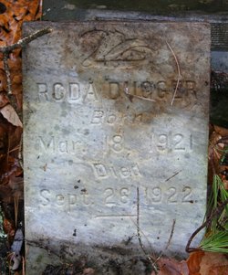
Roda Dugger
| Birth | : | 18 Mar 1921 Carter County, Tennessee, USA |
| Death | : | 26 Sep 1922 Carter County, Tennessee, USA |
| Burial | : | Hatley Cemetery, Carter County, USA |
| Coordinate | : | 36.3087850, -82.0063170 |
| Description | : | The Original HATLEY Cemetery was to be inundated by the Watauga Reservoir due to the 1930's - TVA project. Listed as Not Moved. Original Plot 42-4 TVA documents show death by drowning. ============ 2017 Note: R. A. Crowder The cemetery was not inundated by the filling of the Watauga Lake reservoir. The grave sites are beyond and above the high water mark of the lake. Shared pictures on FindAGrave when headstones found. |
frequently asked questions (FAQ):
-
Where is Roda Dugger's memorial?
Roda Dugger's memorial is located at: Hatley Cemetery, Carter County, USA.
-
When did Roda Dugger death?
Roda Dugger death on 26 Sep 1922 in Carter County, Tennessee, USA
-
Where are the coordinates of the Roda Dugger's memorial?
Latitude: 36.3087850
Longitude: -82.0063170
Family Members:
Parent
Siblings
Flowers:
Nearby Cemetories:
1. Hatley Cemetery
Carter County, USA
Coordinate: 36.3087850, -82.0063170
2. Norris Cemetery
Elk Mills, Carter County, USA
Coordinate: 36.3071500, -82.0158400
3. Lakeview Cemetery
Elk Mills, Carter County, USA
Coordinate: 36.3143997, -81.9978027
4. Campbell Cemetery
Carter County, USA
Coordinate: 36.3171997, -82.0018997
5. Davenport Cemetery
Carter County, USA
Coordinate: 36.2954900, -82.0186500
6. Hatley Cemetery
Carter County, USA
Coordinate: 36.2949200, -82.0216800
7. J. L. Price Cemetery
Buntontown, Johnson County, USA
Coordinate: 36.2891300, -81.9819000
8. Wagner Cemetery
Dry Hill, Johnson County, USA
Coordinate: 36.3292007, -81.9822006
9. Andrews-Tester Cemetery
Buntontown, Johnson County, USA
Coordinate: 36.2937430, -81.9735220
10. Bunton Cemetery
Johnson County, USA
Coordinate: 36.2921982, -81.9744034
11. Greenwell Cemetery
Johnson County, USA
Coordinate: 36.3306007, -81.9785995
12. Carriger Cemetery
Johnson County, USA
Coordinate: 36.3373500, -81.9829100
13. Griffith Cemetery
Carter County, USA
Coordinate: 36.3183000, -82.0474900
14. Goodwin Cemetery #3
Elk Mills, Carter County, USA
Coordinate: 36.2756004, -81.9925003
15. Crosswhite Cemetery
Johnson County, USA
Coordinate: 36.2947006, -81.9649963
16. John Cable Cemetery
Dry Hill, Johnson County, USA
Coordinate: 36.3130989, -81.9606018
17. Elk Mills Baptist Church Cemetery
Carter County, USA
Coordinate: 36.2730100, -81.9935400
18. Hamby Cemetery
Carter County, USA
Coordinate: 36.3152900, -82.0531900
19. Elk Mills Cemetery
Elk Mills, Carter County, USA
Coordinate: 36.2727300, -81.9901400
20. Sugar Grove Baptist Church Cemetery
Dry Hill, Johnson County, USA
Coordinate: 36.3174200, -81.9590100
21. Julius Dugger Cemetery
Dry Hill, Johnson County, USA
Coordinate: 36.3130989, -81.9580994
22. Bailey Cemetery
Carter County, USA
Coordinate: 36.3138700, -82.0554600
23. Sink Valley Cemetery
Butler, Johnson County, USA
Coordinate: 36.3503100, -82.0011700
24. Clawson Cemetery
Carter County, USA
Coordinate: 36.2685300, -81.9917800


