
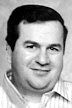

Ronald Charles Schmitt
| Birth | : | 30 Jun 1947 Dubuque, Dubuque County, Iowa, USA |
| Death | : | 25 Oct 2008 |
| Burial | : | Skillingston Cemetery, Bethel, Oxford County, USA |
| Coordinate | : | 44.4085999, -70.8197021 |
| Description | : | From the October 29, 2008 edition of the Dubuque Telegraph Herald RICKARDSVILLE, Iowa -- Ronald C. Schmitt, 61, of Rickardsville, died Saturday, Oct. 25, 2008, at Mercy Medical Center-Dubuque, after a heart attack. Services will be at 11 a.m. Thursday, Oct. 30, at St. Joseph's Catholic Church, Rickardsville, with the Rev. Dean Semmer officiating and the Rev. Raymond Burkle concelebrating. Burial will be in the church cemetery. Friends may call from 3 to 8 p.m. today at Kramer Funeral Home, Holy Cross, where there will be a scripture service will be at 7 p.m. He was born on June 30, 1947, in Dubuque,... Read More |
frequently asked questions (FAQ):
-
Where is Ronald Charles Schmitt's memorial?
Ronald Charles Schmitt's memorial is located at: Skillingston Cemetery, Bethel, Oxford County, USA.
-
When did Ronald Charles Schmitt death?
Ronald Charles Schmitt death on 25 Oct 2008 in
-
Where are the coordinates of the Ronald Charles Schmitt's memorial?
Latitude: 44.4085999
Longitude: -70.8197021
Family Members:
Parent
Flowers:


Nearby Cemetories:
1. Skillingston Cemetery
Bethel, Oxford County, USA
Coordinate: 44.4085999, -70.8197021
2. Riverside Cemetery
Bethel, Oxford County, USA
Coordinate: 44.4202995, -70.8058014
3. Scribner Hill Cemetery Upper Yard
Otisfield, Oxford County, USA
Coordinate: 44.3903181, -70.7978794
4. Woodland Cemetery
Bethel, Oxford County, USA
Coordinate: 44.3902283, -70.7967911
5. Pine Grove Cemetery
West Bethel, Oxford County, USA
Coordinate: 44.4055600, -70.8563100
6. Capen Family Cemetery
Bethel, Oxford County, USA
Coordinate: 44.4382283, -70.7925117
7. Flat Cemetery
West Bethel, Oxford County, USA
Coordinate: 44.3731003, -70.8497009
8. Mason Cemetery
Mason Township, Oxford County, USA
Coordinate: 44.3579270, -70.8525530
9. Mount Will Cemetery
North Bethel, Oxford County, USA
Coordinate: 44.4636002, -70.8028030
10. Chapman Cemetery
Gilead, Oxford County, USA
Coordinate: 44.4114100, -70.9024900
11. South Bethel Cemetery
Bethel, Oxford County, USA
Coordinate: 44.4160995, -70.7363968
12. Middle Intervale Cemetery
Bethel, Oxford County, USA
Coordinate: 44.4638600, -70.7866200
13. Chandler Hill Cemetery
Bethel, Oxford County, USA
Coordinate: 44.4392014, -70.7394028
14. Songo Cemetery
Albany, Oxford County, USA
Coordinate: 44.3464012, -70.7908020
15. Howe Hill Cemetery
Greenwood, Oxford County, USA
Coordinate: 44.3856010, -70.7142029
16. Mount Abram Cemetery
Greenwood, Oxford County, USA
Coordinate: 44.4025002, -70.7078018
17. Sunday River Cemetery
Newry, Oxford County, USA
Coordinate: 44.4888992, -70.8431015
18. Black Family Cemetery
Newry, Oxford County, USA
Coordinate: 44.4889670, -70.7895730
19. Peabody Cemetery
Gilead, Oxford County, USA
Coordinate: 44.3987885, -70.9400635
20. Bird Hill Cemetery
Bethel, Oxford County, USA
Coordinate: 44.4234140, -70.6961680
21. East Bethel Cemetery
East Bethel, Oxford County, USA
Coordinate: 44.4648500, -70.7210200
22. Bartlett Cemetery
East Bethel, Oxford County, USA
Coordinate: 44.4817009, -70.7433014
23. Old Powers Cemetery
Newry, Oxford County, USA
Coordinate: 44.5031013, -70.8178024
24. Hanover Cemetery
Hanover, Oxford County, USA
Coordinate: 44.4850006, -70.7332993