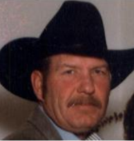
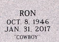
Ronald F “Cowboy” Veith Sr.
| Birth | : | 8 Oct 1946 Wichita, Sedgwick County, Kansas, USA |
| Death | : | 31 Jan 2017 El Dorado, Butler County, Kansas, USA |
| Burial | : | Whitewater Cemetery, Harvey County, USA |
| Coordinate | : | 37.9550018, -97.1699982 |
| Plot | : | Section 5, Lot 93, space B-2nd Row E of East Drive |
| Description | : | Ron's life began on October 8, 1946 in Wichita. He is the son of Alfred and Laverda "Darlene" (Broadhurst) Veith. Ron is a graduate of Bentley High School and is retired from the El Dorado Correctional Facility. He was a jack of all trades-concrete, woodworking, carpentry, and mechanic. He was a rancher, and rode bulls in his youth. Ron enjoyed hunting, fishing and loved his horses and cattle. He was united in marriage to Mary F. Carter in 1995 in El Dorado. His loving family includes his sons Ryan Veith of El Dorado, Steve... Read More |
frequently asked questions (FAQ):
-
Where is Ronald F “Cowboy” Veith Sr.'s memorial?
Ronald F “Cowboy” Veith Sr.'s memorial is located at: Whitewater Cemetery, Harvey County, USA.
-
When did Ronald F “Cowboy” Veith Sr. death?
Ronald F “Cowboy” Veith Sr. death on 31 Jan 2017 in El Dorado, Butler County, Kansas, USA
-
Where are the coordinates of the Ronald F “Cowboy” Veith Sr.'s memorial?
Latitude: 37.9550018
Longitude: -97.1699982
Family Members:
Parent
Spouse
Siblings
Children
Flowers:
Nearby Cemetories:
1. Whitewater Cemetery
Harvey County, USA
Coordinate: 37.9550018, -97.1699982
2. Swiss Cemetery
Whitewater, Butler County, USA
Coordinate: 37.9799995, -97.1343994
3. Harder Cemetery
Brainerd, Butler County, USA
Coordinate: 37.9593800, -97.1161600
4. Emmaus Mennonite Church South Cemetery
Brainerd, Butler County, USA
Coordinate: 37.9569000, -97.0951000
5. Old Grace Hill Mennonite Church Cemetery
Harvey County, USA
Coordinate: 38.0128870, -97.1859870
6. Brainerd Cemetery
Brainerd, Butler County, USA
Coordinate: 37.9566994, -97.0932999
7. Joseph Golden Gravesite
Annelly, Harvey County, USA
Coordinate: 37.9698700, -97.2456600
8. Emmaus Mennonite Church Cemetery
Whitewater, Butler County, USA
Coordinate: 37.9855200, -97.0989400
9. Green Valley Cemetery
Furley, Sedgwick County, USA
Coordinate: 37.8842010, -97.1694031
10. Grace Hill Mennonite Church Cemetery
Harvey County, USA
Coordinate: 38.0289800, -97.1803300
11. Horace Hayes Gravesite
Newton, Harvey County, USA
Coordinate: 38.0435950, -97.1757810
12. Missionary Church Cemetery
Harvey County, USA
Coordinate: 38.0581017, -97.1622009
13. Pleasant View Cemetery
Elbing, Butler County, USA
Coordinate: 38.0499992, -97.1153030
14. Shafer Cemetery
Potwin, Butler County, USA
Coordinate: 37.9075012, -97.0483017
15. Adams Family Cemetery
Butler County, USA
Coordinate: 37.9850311, -97.0330963
16. Potwin Cemetery
Potwin, Butler County, USA
Coordinate: 37.9423027, -97.0250702
17. Lorraine Avenue Mennonite Church Cemetery
Valley Center, Sedgwick County, USA
Coordinate: 37.8408012, -97.1977997
18. Fairmount Lonestar Cemetery
Butler County, USA
Coordinate: 38.0285500, -97.0514200
19. McGill Cemetery
Potwin, Butler County, USA
Coordinate: 37.9188995, -97.0246964
20. Harvey County Memorial
Newton, Harvey County, USA
Coordinate: 38.0716090, -97.2184190
21. Union Cemetery
Benton, Butler County, USA
Coordinate: 37.8314018, -97.1331024
22. Zion Cemetery
Elbing, Butler County, USA
Coordinate: 38.0783005, -97.1160965
23. Haldeman Cemetery
Butler County, USA
Coordinate: 37.9989014, -97.0132980
24. 101 Club Cemetery
Valley Center, Sedgwick County, USA
Coordinate: 37.8697132, -97.3141009


