
| Birth | : | Dec 1854 California, USA |
| Death | : | 27 Nov 1926 Stockton, San Joaquin County, California, USA |
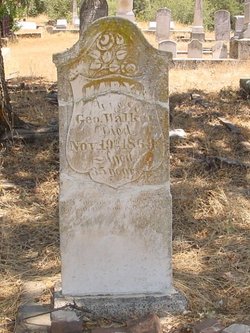
| Burial | : | Ione Public Cemetery, Ione, Amador County, USA |
| Coordinate | : | 38.3478830, -120.9322000 |
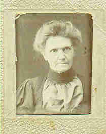
| Description | : | Rosa's father was killed by her new stepfather and so for reasons we will never know, she married a man 22 years older than she (she was 15 or 16) and they had 3 children. Her husband, Conrad Raab, died in 1885. The children were 14, 12, and 11. Agnes, her youngest daughter, was a grammer school teacher and lived with her mother through the 1910 census. Sometime after the census was taken, Rosa was admitted into the Stockton State Hospital with tuberculosis and she died there 15 years, 10 months and 17 days later. She was buried... Read More |
frequently asked questions (FAQ):
-
Where is Rosalia “Rosa” Bennett Raab's memorial?
Rosalia “Rosa” Bennett Raab's memorial is located at: Ione Public Cemetery, Ione, Amador County, USA.
-
When did Rosalia “Rosa” Bennett Raab death?
Rosalia “Rosa” Bennett Raab death on 27 Nov 1926 in Stockton, San Joaquin County, California, USA
-
Where are the coordinates of the Rosalia “Rosa” Bennett Raab's memorial?
Latitude: 38.3478830
Longitude: -120.9322000
Family Members:
Parent

Spouse
Siblings
Flowers:


Nearby Cemetories:
1. Ione Catholic Cemetery
Ione, Amador County, USA
Coordinate: 38.3483040, -120.9329300
2. Preston School of Industry Cemetery
Ione, Amador County, USA
Coordinate: 38.3608440, -120.9371870
3. Tolopiyu Cemetery
Ione, Amador County, USA
Coordinate: 38.3186300, -120.9410800
4. Buena Vista Rancheria Indian Cemetery
Ione, Amador County, USA
Coordinate: 38.2731600, -120.9107900
5. Sunset View Cemetery
Martell, Amador County, USA
Coordinate: 38.3534390, -120.8328030
6. Odd Fellows Cemetery
Sutter Creek, Amador County, USA
Coordinate: 38.3964120, -120.8110550
7. Sutter Creek Catholic Cemetery
Sutter Creek, Amador County, USA
Coordinate: 38.3955780, -120.8101970
8. Sutter Creek City Cemetery
Sutter Creek, Amador County, USA
Coordinate: 38.3957520, -120.8091940
9. Immaculate Conception Parish Cemetery
Sutter Creek, Amador County, USA
Coordinate: 38.3956980, -120.8063430
10. Drytown City Cemetery
Amador County, USA
Coordinate: 38.4407425, -120.8577118
11. Amador City Cemetery
Amador City, Amador County, USA
Coordinate: 38.4198000, -120.8252000
12. Oak Knoll Cemetery
Amador City, Amador County, USA
Coordinate: 38.4263992, -120.8300018
13. Saint Stephens Cemetery
Drytown, Amador County, USA
Coordinate: 38.4417730, -120.8522840
14. Saint Sava Serbian Orthodox Cemetery
Jackson, Amador County, USA
Coordinate: 38.3560530, -120.7764530
15. Jackson Gate Perano Cemetery
Jackson, Amador County, USA
Coordinate: 38.3701640, -120.7778150
16. Saint Patrick Catholic Cemetery
Jackson, Amador County, USA
Coordinate: 38.3534780, -120.7742350
17. Amador County Museum
Jackson, Amador County, USA
Coordinate: 38.3507000, -120.7733900
18. Jackson City Cemetery
Jackson, Amador County, USA
Coordinate: 38.3519640, -120.7731340
19. Pioneer Jewish Cemetery
Jackson, Amador County, USA
Coordinate: 38.3539790, -120.7724540
20. Parsons Plot
New Chicago, Amador County, USA
Coordinate: 38.4354000, -120.8174100
21. Chinese Cemetery
Jackson, Amador County, USA
Coordinate: 38.3674680, -120.7655440
22. Campo Seco Protestant Cemetery
Campo Seco, Calaveras County, USA
Coordinate: 38.2258880, -120.8569960
23. Campo Seco Catholic Cemetery
Campo Seco, Calaveras County, USA
Coordinate: 38.2223740, -120.8579460
24. Cowboy Park Cemetery
Plymouth, Amador County, USA
Coordinate: 38.4787060, -120.8522060