
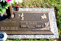
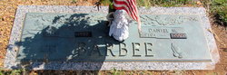
Roscoe Faris Barbee
| Birth | : | 22 Feb 1946 Union County, North Carolina, USA |
| Death | : | 8 Jan 2010 Union County, North Carolina, USA |
| Burial | : | Kopuatama Cemetery, Stratford, Stratford District, New Zealand |
| Coordinate | : | -39.3364400, 174.3364500 |
| Description | : | MONROE -- Mr. R. Faris Barbee, 63, died Friday, January 8, 2010, at his residence, surrounded by his loving family. Mr. Barbee was born February 22, 1956, in Union County, N.C., son of the late Daniel Millard and Ida Maxine Whitley Barbee. Faris was a well-known artist in Union and Mecklenburg counties. He was a member of the U.S. Ski Team, ISA Figure Skating Federation, and Carolina Figure Skating Club, winning numerous medals and awards in both sports. His last competition was September 19, 2009, when he won two gold medals in figure skating. When not at home with his beloved family, driving... Read More |
frequently asked questions (FAQ):
-
Where is Roscoe Faris Barbee's memorial?
Roscoe Faris Barbee's memorial is located at: Kopuatama Cemetery, Stratford, Stratford District, New Zealand.
-
When did Roscoe Faris Barbee death?
Roscoe Faris Barbee death on 8 Jan 2010 in Union County, North Carolina, USA
-
Where are the coordinates of the Roscoe Faris Barbee's memorial?
Latitude: -39.3364400
Longitude: 174.3364500
Family Members:
Parent

Siblings

Flowers:


Nearby Cemetories:
1. Pioneer Cemetery
Stratford, Stratford District, New Zealand
Coordinate: -39.3359800, 174.2929000
2. Midhirst Old Cemetery
Midhirst, Stratford District, New Zealand
Coordinate: -39.2911920, 174.2731980
3. Midhirst Cemetery
Midhirst, Stratford District, New Zealand
Coordinate: -39.2913640, 174.2724620
4. Eltham Cemetery
Eltham, South Taranaki District, New Zealand
Coordinate: -39.4197140, 174.3251260
5. Kaponga Cemetery
Kaponga, South Taranaki District, New Zealand
Coordinate: -39.4312210, 174.1553160
6. Tarata Cemetery
Tarata, New Plymouth District, New Zealand
Coordinate: -39.1496000, 174.3658200
7. Te Ngutu o te Manu Battlesite Memorial
Kapuni, South Taranaki District, New Zealand
Coordinate: -39.4876351, 174.1838147
8. Te Utinga Urupā
Normanby, South Taranaki District, New Zealand
Coordinate: -39.5330847, 174.2761055
9. Weri Weri Urupa Aotearoa Marae
Okaiawa, South Taranaki District, New Zealand
Coordinate: -39.5190700, 174.2206700
10. Inglewood Cemetery
Inglewood, New Plymouth District, New Zealand
Coordinate: -39.1554140, 174.2145930
11. Waihi Cemetery and Redoubt
Normanby, South Taranaki District, New Zealand
Coordinate: -39.5444930, 174.2566820
12. Okaiawa Cemetery
Okaiawa, South Taranaki District, New Zealand
Coordinate: -39.5310220, 174.2042180
13. Purangi Cemetery
Purangi, New Plymouth District, New Zealand
Coordinate: -39.1571550, 174.5287180
14. Tiwhaiti Urupa (Taiporohenui Marae)
Hāwera, South Taranaki District, New Zealand
Coordinate: -39.5741843, 174.3216120
15. Motuawa Urupā Waiokura Marae
Manaia, South Taranaki District, New Zealand
Coordinate: -39.5388010, 174.1438990
16. Hāwera Cemetery
Hāwera, South Taranaki District, New Zealand
Coordinate: -39.5897900, 174.2945500
17. Mangapouri Cemetery
Egmont Village, New Plymouth District, New Zealand
Coordinate: -39.1347278, 174.1282396
18. Manaia Redoubt
Manaia, South Taranaki District, New Zealand
Coordinate: -39.5461557, 174.1364306
19. Ohawe Military Cemetery
Ohawe Beach, South Taranaki District, New Zealand
Coordinate: -39.5835138, 174.2003758
20. Manaia Cemetery
Manaia, South Taranaki District, New Zealand
Coordinate: -39.5575010, 174.1354470
21. Taranaki Crematorium
New Plymouth, New Plymouth District, New Zealand
Coordinate: -39.1216900, 174.1149500
22. Huirangi Cemetery
Huirangi, New Plymouth District, New Zealand
Coordinate: -39.0500060, 174.2513380
23. O'Carroll Family Cemetery
New Plymouth District, New Zealand
Coordinate: -39.0465210, 174.2651080
24. Lepperton Cemetery
Lepperton, New Plymouth District, New Zealand
Coordinate: -39.0575500, 174.2086000