
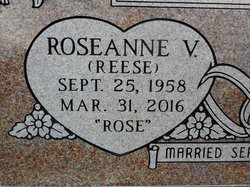
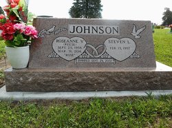

Roseanne Viola “Rose” Reese Johnson
| Birth | : | 25 Sep 1958 Albert Lea, Freeborn County, Minnesota, USA |
| Death | : | 31 Mar 2016 Pawnee City, Pawnee County, Nebraska, USA |
| Burial | : | Pawnee City Cemetery, Pawnee City, Pawnee County, USA |
| Coordinate | : | 40.1109009, -96.1608810 |
| Description | : | Roseanne is the daughter of Orville Irven Reese & Betty Ellen (Jacobson) Reese Manteuffel. Roseanne married Joseph William 'Joe' Stobaugh around 1987 in Clark County, Nevada. They later divorced, without children. Roseanne married Steven Johnson on September 25, 2001 at Good Samaritan Nursing Home in Syracuse, Nebraska. ******** Wherry Mortuary; March 31, 2016 Roseanne “Rose” Johnson (Reese), 57 of Pawnee City, Nebraska passed away on Thursday, March 31, 2016 in Pawnee City, Nebraska. She was born on September 25, 1958 in Minneapolis, Minnesota to Orville and Betty (Jacobson) Reese. Rose... Read More |
frequently asked questions (FAQ):
-
Where is Roseanne Viola “Rose” Reese Johnson's memorial?
Roseanne Viola “Rose” Reese Johnson's memorial is located at: Pawnee City Cemetery, Pawnee City, Pawnee County, USA.
-
When did Roseanne Viola “Rose” Reese Johnson death?
Roseanne Viola “Rose” Reese Johnson death on 31 Mar 2016 in Pawnee City, Pawnee County, Nebraska, USA
-
Where are the coordinates of the Roseanne Viola “Rose” Reese Johnson's memorial?
Latitude: 40.1109009
Longitude: -96.1608810
Family Members:

Flowers:


Nearby Cemetories:
1. Pawnee City Cemetery
Pawnee City, Pawnee County, USA
Coordinate: 40.1109009, -96.1608810
2. East Amish Cemetery
Table Rock, Pawnee County, USA
Coordinate: 40.1310000, -96.0854000
3. Evergreen Cemetery
Pawnee County, USA
Coordinate: 40.0485992, -96.1417007
4. Pleasant Valley Cemetery
Pawnee County, USA
Coordinate: 40.0299988, -96.1554794
5. Table Rock Cemetery
Table Rock, Pawnee County, USA
Coordinate: 40.1791400, -96.1037400
6. Prairie Star Pioneer Cemetery
Du Bois, Pawnee County, USA
Coordinate: 40.0293000, -96.1041000
7. Beranek Cemetery
Table Rock, Pawnee County, USA
Coordinate: 40.2042007, -96.1607971
8. Pleasant Ridge Cemetery
Du Bois, Pawnee County, USA
Coordinate: 40.0156000, -96.1494000
9. West Branch Cemetery
Pawnee County, USA
Coordinate: 40.0787940, -96.2797160
10. Saint Anthonys Cemetery
Steinauer, Pawnee County, USA
Coordinate: 40.2075005, -96.2189026
11. Johnson Creek Cemetery
Pawnee City, Pawnee County, USA
Coordinate: 40.0270000, -96.2465000
12. Clear Creek Cemetery
Table Rock, Pawnee County, USA
Coordinate: 40.2193985, -96.1391983
13. Bohemian Cemetery
Table Rock, Pawnee County, USA
Coordinate: 40.1786003, -96.0374985
14. Saint Peters Evangelican Cemetery
Du Bois, Pawnee County, USA
Coordinate: 40.0010000, -96.1095000
15. Dry Branch Pioneer Cemetery
Richardson County, USA
Coordinate: 40.1292000, -96.0100021
16. DuBois Cemetery
Du Bois, Pawnee County, USA
Coordinate: 40.0231018, -96.0488968
17. Bohemian Cemetery
Richardson County, USA
Coordinate: 40.1175003, -95.9955978
18. Saint Johns Cemetery
Table Rock, Pawnee County, USA
Coordinate: 40.2148000, -96.0657000
19. Salems Cemetery
Steinauer, Pawnee County, USA
Coordinate: 40.2166000, -96.2555000
20. McCaffrey Cemetery
Nemaha County, USA
Coordinate: 39.9827100, -96.1474500
21. Madden Cemetery
Axtell, Marshall County, USA
Coordinate: 39.9866800, -96.2490300
22. Friedens United Church of Christ Cemetery
Bern, Nemaha County, USA
Coordinate: 39.9929008, -96.0529480
23. Saint Peters Lutheran Church Cemetery
Steinauer, Pawnee County, USA
Coordinate: 40.2555000, -96.1801000
24. Cincinnati Cemetery
Du Bois, Pawnee County, USA
Coordinate: 40.0042000, -96.0274963