

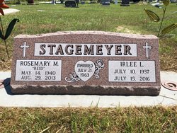
Rosemary Marie Reid Stagemeyer
| Birth | : | 14 May 1940 Oxford, Furnas County, Nebraska, USA |
| Death | : | 29 Aug 2013 Cambridge, Furnas County, Nebraska, USA |
| Burial | : | Saint Matthew Lutheran Cemetery, Elwood, Gosper County, USA |
| Coordinate | : | 40.3519000, -99.9630000 |
| Description | : | Rosemary M. Stagemeyer, age 73, of Holbrook, Nebraska passed away on Thursday, August 29, 2013 at Cambridge Memorial Hospital in Cambridge, Nebraska. She was born on May 14, 1940 at Oxford, Nebraska to Chester and Thelma (Brown) Reid. Rosemary was baptized on February 12, 1954, at the First Christian Church in Beaver City, Nebraska and confirmed at Zion Lutheran Church in Kearney, Nebraska in May of 1963. She received her formal education at Beaver City High School and graduated with the class of 1958. She later attended Kearney State College where she graduated with a degree in Home Economics education. On... Read More |
frequently asked questions (FAQ):
-
Where is Rosemary Marie Reid Stagemeyer's memorial?
Rosemary Marie Reid Stagemeyer's memorial is located at: Saint Matthew Lutheran Cemetery, Elwood, Gosper County, USA.
-
When did Rosemary Marie Reid Stagemeyer death?
Rosemary Marie Reid Stagemeyer death on 29 Aug 2013 in Cambridge, Furnas County, Nebraska, USA
-
Where are the coordinates of the Rosemary Marie Reid Stagemeyer's memorial?
Latitude: 40.3519000
Longitude: -99.9630000
Family Members:
Flowers:


Nearby Cemetories:
1. Saint Matthew Lutheran Cemetery
Elwood, Gosper County, USA
Coordinate: 40.3519000, -99.9630000
2. Holbrook Cemetery
Holbrook, Furnas County, USA
Coordinate: 40.3138000, -100.0045000
3. Arapahoe Cemetery
Arapahoe, Furnas County, USA
Coordinate: 40.3239600, -99.8985500
4. Miller Cemetery
Elwood, Gosper County, USA
Coordinate: 40.3514980, -100.0374350
5. Norwegian Lutheran Cemetery
Holbrook, Furnas County, USA
Coordinate: 40.3380910, -100.0425560
6. East Muddy Cemetery
Gosper County, USA
Coordinate: 40.4166985, -99.9614029
7. Immanuel Lutheran Cemetery
Elwood, Gosper County, USA
Coordinate: 40.4206500, -99.8672000
8. McGuire Cemetery
Gosper County, USA
Coordinate: 40.4380989, -99.8664017
9. Garfield Cemetery
Furnas County, USA
Coordinate: 40.2491989, -99.8992004
10. Pleasant Grove Cemetery
Gosper County, USA
Coordinate: 40.4664001, -99.9250031
11. Homerville Cemetery
Gosper County, USA
Coordinate: 40.4668999, -99.8593979
12. Edison Cemetery
Edison, Furnas County, USA
Coordinate: 40.2919006, -99.7902985
13. Salem East Cemetery
Gosper County, USA
Coordinate: 40.4972000, -99.9803009
14. Salem West Cemetery
Frontier County, USA
Coordinate: 40.4968987, -99.9886017
15. Pleasantview Cemetery
Arapahoe, Furnas County, USA
Coordinate: 40.2043991, -99.9669037
16. Stump Cemetery
Furnas County, USA
Coordinate: 40.3478012, -99.7621994
17. Stowe Cemetery
Stockville, Frontier County, USA
Coordinate: 40.4900017, -100.0753021
18. Saint John's Catholic Cemetery
Cambridge, Furnas County, USA
Coordinate: 40.2850000, -100.1817000
19. Fairview Cemetery
Cambridge, Furnas County, USA
Coordinate: 40.2849998, -100.1817017
20. Highland Union Cemetery
Gosper County, USA
Coordinate: 40.3513990, -99.7172360
21. Fairfield Cemetery
Gosper County, USA
Coordinate: 40.4672012, -99.7549973
22. Denny Cemetery
Frontier County, USA
Coordinate: 40.4393997, -100.2082977
23. Zion Cemetery
Gosper County, USA
Coordinate: 40.4085999, -99.7005997
24. Hammond Cemetery
Frontier County, USA
Coordinate: 40.4002953, -100.2353134