
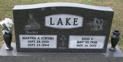
Ross Lake
| Birth | : | 25 May 1928 Barnett, Morgan County, Missouri, USA |
| Death | : | 14 Nov 2001 Jefferson City, Cole County, Missouri, USA |
| Burial | : | Olean Cemetery, Olean, Miller County, USA |
| Coordinate | : | 38.4131012, -92.5413971 |
| Description | : | Obituary: Jefferson City Post Tribune, Friday, November 16, 2001 Ross Lake, 73, Olean, died Nov. 14, 2001, at St. Mary's Health Center. He was born May 25, 1928, in Barnett, a son of Elmer H. and Anna Belle Wells Lake. He was married Dec. 24, 1952, in Olean, to Martha Crum, who died Sept. 23, 1994. A lifelong resident of Olean and Eldon, he operated a dairy farm, retiring in 1989. He was an Army veteran. Survivors include: one son, Robert Lake, Eugene; one brother, Wilmer Lake, Versailles; one sister, Mildred Queen, Seattle; and three... Read More |
frequently asked questions (FAQ):
-
Where is Ross Lake's memorial?
Ross Lake's memorial is located at: Olean Cemetery, Olean, Miller County, USA.
-
When did Ross Lake death?
Ross Lake death on 14 Nov 2001 in Jefferson City, Cole County, Missouri, USA
-
Where are the coordinates of the Ross Lake's memorial?
Latitude: 38.4131012
Longitude: -92.5413971
Family Members:

Flowers:


Nearby Cemetories:
1. Olean Cemetery
Olean, Miller County, USA
Coordinate: 38.4131012, -92.5413971
2. Green Ridge Baptist Church Cemetery
Eldon, Miller County, USA
Coordinate: 38.4116200, -92.5645700
3. Etter-Walker Cemetery
Burris Fork, Moniteau County, USA
Coordinate: 38.4333700, -92.5525400
4. Walker Cemetery
Moniteau County, USA
Coordinate: 38.4338989, -92.5522003
5. Farris Cemetery
Moniteau County, USA
Coordinate: 38.4369900, -92.5380000
6. Allen Cemetery
Olean, Miller County, USA
Coordinate: 38.4150009, -92.5008011
7. Jackson Chapel Methodist Church Cemetery
California, Moniteau County, USA
Coordinate: 38.4447900, -92.5286500
8. Gray Cemetery
Moniteau County, USA
Coordinate: 38.4536018, -92.5456009
9. Hite Cemetery
Miller County, USA
Coordinate: 38.4039001, -92.5935974
10. Mount Pleasant Cemetery
Eldon, Miller County, USA
Coordinate: 38.3667700, -92.5300800
11. Salem Cemetery
Saline Township, Miller County, USA
Coordinate: 38.3691232, -92.5697260
12. Salem Cemetery
Eldon, Miller County, USA
Coordinate: 38.3697014, -92.5714035
13. Mount Vernon Cemetery
Eldon, Miller County, USA
Coordinate: 38.3624992, -92.5606003
14. Bruce-Lewis-McGahan Cemetery
Enon, Moniteau County, USA
Coordinate: 38.4667500, -92.5172100
15. Rock Enon Cemetery
Miller County, USA
Coordinate: 38.4668400, -92.5170700
16. Eldon Cemetery
Eldon, Miller County, USA
Coordinate: 38.3642006, -92.5868988
17. Phillips Cemetery
High Point, Moniteau County, USA
Coordinate: 38.4430300, -92.6125300
18. Colburn Cemetery
Eldon, Miller County, USA
Coordinate: 38.4246300, -92.6275500
19. Depp Cemetery
High Point, Moniteau County, USA
Coordinate: 38.4776400, -92.5818500
20. High Point Cemetery
High Point, Moniteau County, USA
Coordinate: 38.4817009, -92.5757980
21. Phillips Cemetery
Barnett, Morgan County, USA
Coordinate: 38.4227982, -92.6367035
22. Matheis Cemetery
Russellville, Cole County, USA
Coordinate: 38.4571800, -92.4491600
23. United Baptist Church Cemetery
High Point, Moniteau County, USA
Coordinate: 38.4962200, -92.5856800
24. Karnes-Carney-Henderson Cemetery
Burris Fork, Moniteau County, USA
Coordinate: 38.4992100, -92.5007510