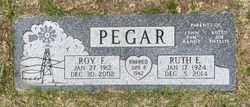
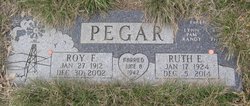
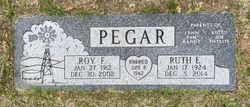
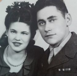
Roy Frederick Pegar
| Birth | : | 27 Jan 1912 Jefferson, Union County, South Dakota, USA |
| Death | : | 30 Dec 2002 Havre, Hill County, Montana, USA |
| Burial | : | Bluff Cemetery, Bluff, San Juan County, USA |
| Coordinate | : | 37.2877998, -109.5541992 |
| Description | : | The Following provided by Find A Grave contributor "Cara" Great Falls Tribune (MT), 1 Jan 2003 Big Sandy/Havre--Roy F. Pegar, 90, a retired farmer, died of natural causes Monday at a Havre hospital. A celebration of life is 2 p.m. Friday at the Big Sandy High School auditorium, with burial in Big Sandy Cemetery. A luncheon will take place at Big Sandy Methodist Church after the burial. Holland and Bonine Funeral Home is in charge of arrangements. Survivors include his wife; three sons; three daughters; 17 grandchildren and 17 great-grandchildren. He was preceded in death by a grandson. ---------------------------------------- Additional information provided by... Read More |
frequently asked questions (FAQ):
-
Where is Roy Frederick Pegar's memorial?
Roy Frederick Pegar's memorial is located at: Bluff Cemetery, Bluff, San Juan County, USA.
-
When did Roy Frederick Pegar death?
Roy Frederick Pegar death on 30 Dec 2002 in Havre, Hill County, Montana, USA
-
Where are the coordinates of the Roy Frederick Pegar's memorial?
Latitude: 37.2877998
Longitude: -109.5541992
Family Members:
Parent
Spouse
Siblings
Flowers:
Nearby Cemetories:
1. Bluff Cemetery
Bluff, San Juan County, USA
Coordinate: 37.2877998, -109.5541992
2. Saint Christophers Cemetery
Bluff, San Juan County, USA
Coordinate: 37.2852700, -109.5128500
3. White Rock Point Cemetery
Tselakai Dezza, San Juan County, USA
Coordinate: 37.2237010, -109.6055910
4. Montezuma Creek Cemetery
San Juan County, USA
Coordinate: 37.2623000, -109.3047000
5. White Mesa Village Cemetery
San Juan County, USA
Coordinate: 37.1630600, -109.2660900
6. Sunrise Cemetery
San Juan County, USA
Coordinate: 37.0650200, -109.3772200
7. Red Mesa Community Cemetery
San Juan County, USA
Coordinate: 37.0650200, -109.3771100
8. Aneth Area Burials
Aneth, San Juan County, USA
Coordinate: 37.2321000, -109.2131000
9. Mexican Water Community Cemetery
Mexican Water, Apache County, USA
Coordinate: 36.9710200, -109.6274600
10. Blanding City Cemetery
Blanding, San Juan County, USA
Coordinate: 37.6307983, -109.4682999
11. Tes Nes Iah Cemetery
Apache County, USA
Coordinate: 36.9434300, -109.7091300
12. Allen Canyon Ute Cemetery
Blanding, San Juan County, USA
Coordinate: 37.6595900, -109.6340300
13. Immanuel Mission Cemetery
Coyote Springs, Apache County, USA
Coordinate: 36.8033170, -109.3964770
14. Harry Hopkins Gravesite
San Juan County, USA
Coordinate: 37.7830010, -109.4367980
15. Verdure Cemetery
Verdure, San Juan County, USA
Coordinate: 37.7837000, -109.3461000
16. Teec Nos Pos Cemetery
Teec Nos Pos, Apache County, USA
Coordinate: 36.9208890, -109.0867170
17. Urado Cemetery
San Juan County, USA
Coordinate: 37.6459000, -109.0590000
18. Dennehotso Community Cemetery
Dennehotso, Apache County, USA
Coordinate: 36.8079090, -109.8884020
19. Cedar Point Cemetery
San Juan County, USA
Coordinate: 37.7057000, -109.0819000
20. McElmo Cemetery
Montezuma County, USA
Coordinate: 37.3374405, -108.8397980
21. Battlerock Cemetery
Montezuma County, USA
Coordinate: 37.3375000, -108.8395000
22. Monument Valley Cemetery
San Juan County, USA
Coordinate: 37.0266800, -110.1977300
23. Lamb Cemetery
Montezuma County, USA
Coordinate: 37.3418999, -108.8099976
24. Sylvan Cemetery
Pleasant View, Montezuma County, USA
Coordinate: 37.5797005, -108.8850021

