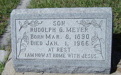
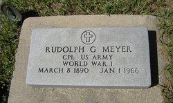
Rudolph G. Meyer
| Birth | : | 8 Mar 1890 Lincoln County, Kansas, USA |
| Death | : | 1 Jan 1966 Sylvan Grove, Lincoln County, Kansas, USA |
| Burial | : | Forest Mound Cemetery, Waupun, Fond du Lac County, USA |
| Coordinate | : | 43.6391716, -88.7316666 |
| Inscription | : | Cpl. US Army World War I |
frequently asked questions (FAQ):
-
Where is Rudolph G. Meyer's memorial?
Rudolph G. Meyer's memorial is located at: Forest Mound Cemetery, Waupun, Fond du Lac County, USA.
-
When did Rudolph G. Meyer death?
Rudolph G. Meyer death on 1 Jan 1966 in Sylvan Grove, Lincoln County, Kansas, USA
-
Where are the coordinates of the Rudolph G. Meyer's memorial?
Latitude: 43.6391716
Longitude: -88.7316666
Family Members:
Parent
Spouse
Siblings
Flowers:
Nearby Cemetories:
1. Forest Mound Cemetery
Waupun, Fond du Lac County, USA
Coordinate: 43.6391716, -88.7316666
2. Calvary Cemetery
Waupun, Fond du Lac County, USA
Coordinate: 43.6472015, -88.7296982
3. Waupun Cemetery
Waupun, Dodge County, USA
Coordinate: 43.6275220, -88.7248780
4. Wisconsin State Prison Cemetery
Waupun, Dodge County, USA
Coordinate: 43.6291640, -88.7046860
5. Cattaraugus Cemetery
Waupun, Fond du Lac County, USA
Coordinate: 43.6506004, -88.6992035
6. Norwegian Evangelical Lutheran Cemetery
Waupun, Fond du Lac County, USA
Coordinate: 43.6458200, -88.6540000
7. Alto Cemetery
Alto, Fond du Lac County, USA
Coordinate: 43.6758308, -88.7933273
8. Calvary Cemetery
Alto, Fond du Lac County, USA
Coordinate: 43.6624400, -88.8177600
9. Oak Mound Cemetery
Alto, Fond du Lac County, USA
Coordinate: 43.6892014, -88.7977982
10. Atwater Cemetery
Atwater, Dodge County, USA
Coordinate: 43.5648450, -88.7254140
11. Wedges Prairie Cemetery
Waupun, Fond du Lac County, USA
Coordinate: 43.7193985, -88.6939011
12. Rock River Cemetery
Oakfield, Fond du Lac County, USA
Coordinate: 43.6856003, -88.6296997
13. Oak Center Cemetery
Oak Center, Fond du Lac County, USA
Coordinate: 43.6466600, -88.6009400
14. Burnett Union Cemetery
Burnett, Dodge County, USA
Coordinate: 43.5448151, -88.7120285
15. Highland Memory Gardens
Trenton, Dodge County, USA
Coordinate: 43.5470009, -88.7809982
16. West Alto Cemetery
Alto, Fond du Lac County, USA
Coordinate: 43.6697006, -88.8660965
17. Trenton Cemetery
Trenton, Dodge County, USA
Coordinate: 43.5671997, -88.8313980
18. Miles Farm Cemetery
LeRoy, Dodge County, USA
Coordinate: 43.6251880, -88.5917650
19. Brandon Cemetery
Brandon, Fond du Lac County, USA
Coordinate: 43.7327805, -88.7897186
20. Union Prairie Cemetery
Brandon, Fond du Lac County, USA
Coordinate: 43.7388560, -88.7658410
21. East Ladoga Cemetery
Ladoga, Fond du Lac County, USA
Coordinate: 43.7228012, -88.6418991
22. Grand Prairie Cemetery
Fox Lake, Dodge County, USA
Coordinate: 43.6314011, -88.8968964
23. Springvale Prairie Cemetery
Rosendale, Fond du Lac County, USA
Coordinate: 43.7594700, -88.7196400
24. Wood Cemetery
Alto, Fond du Lac County, USA
Coordinate: 43.7203167, -88.8556177

