
Ruth Ann Koresky Elwood
| Birth | : | 24 Jan 1898 Richfield, Sarpy County, Nebraska, USA |
| Death | : | 4 Sep 1972 Rushville, Sheridan County, Nebraska, USA |
| Burial | : | Gordon Cemetery, Gordon, Sheridan County, USA |
| Coordinate | : | 42.7858009, -102.2102966 |
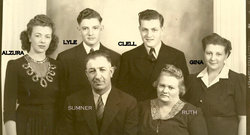
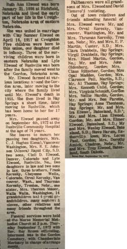
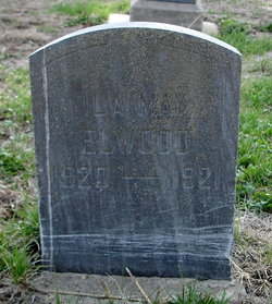
| Description | : | Ruth Ann Elwood was born January 21, 1898 at Richfield, Nebraska. She lived the early part of her life in the Creighton, Nebraska area. She was united in marriage with Clay Sumner Elwood April 16, 1817 at Creighton. Five children were born to this union. One daughter died in infancy. Three of the surviving children were born in eastern Nebraska, Lyle of Rushville was born after the family moved west to the Gordon, Nebraska area. Mr. Elwood farmed at various locations around the Gordon area, later moving to the city, where the family lived until Mr. Elwood's death in 1955. Mrs. Elwood, then,... Read More |
frequently asked questions (FAQ):
-
Where is Ruth Ann Koresky Elwood's memorial?
Ruth Ann Koresky Elwood's memorial is located at: Gordon Cemetery, Gordon, Sheridan County, USA.
-
When did Ruth Ann Koresky Elwood death?
Ruth Ann Koresky Elwood death on 4 Sep 1972 in Rushville, Sheridan County, Nebraska, USA
-
Where are the coordinates of the Ruth Ann Koresky Elwood's memorial?
Latitude: 42.7858009
Longitude: -102.2102966
Family Members:
Spouse
Children
Flowers:


Nearby Cemetories:
1. Gordon Cemetery
Gordon, Sheridan County, USA
Coordinate: 42.7858009, -102.2102966
2. Mount Hope Cemetery
Gordon, Sheridan County, USA
Coordinate: 42.7113991, -102.2241974
3. Dane Cemetery
Cherry County, USA
Coordinate: 42.7924300, -102.0824700
4. Bethel Cemetery
Sheridan County, USA
Coordinate: 42.9011002, -102.3208008
5. Lavaca Cemetery
Irwin, Cherry County, USA
Coordinate: 42.7332993, -102.0175018
6. Amity Cemetery
Sheridan County, USA
Coordinate: 42.8036003, -102.4389038
7. Fair View Cemetery
Rushville, Sheridan County, USA
Coordinate: 42.7155991, -102.4325027
8. Saint Aloysius Cemetery
Sheridan County, USA
Coordinate: 42.9015500, -102.4025500
9. Saint Marys Cemetery
Rushville, Sheridan County, USA
Coordinate: 42.7174988, -102.4436035
10. Feather on Head Cemetery
Oglala Lakota County, USA
Coordinate: 43.0311012, -102.1611023
11. Holly Cemetery
Rushville, Sheridan County, USA
Coordinate: 42.8575120, -102.5370990
12. Novotny Cemetery
Hay Springs, Sheridan County, USA
Coordinate: 42.7742004, -102.5963974
13. Davis Cemetery
Rushville, Sheridan County, USA
Coordinate: 42.5421000, -102.4118800
14. Wolf Creek Community Cemetery
Oglala Lakota County, USA
Coordinate: 43.0405750, -102.3966490
15. Spotted Bear Family Cemetery
Denby, Oglala Lakota County, USA
Coordinate: 43.0608200, -102.3376600
16. Preble Cemetery
Sheridan County, USA
Coordinate: 42.6504000, -102.5765000
17. Abold Family Cemetery
Rushville, Sheridan County, USA
Coordinate: 42.8863500, -102.6158000
18. Bomar Cemetery
Hay Springs, Sheridan County, USA
Coordinate: 42.8062000, -102.6459600
19. Native American Cemetery
Oglala, Oglala Lakota County, USA
Coordinate: 43.0886002, -102.3550034
20. White Clay Cemetery
Rushville, Sheridan County, USA
Coordinate: 42.9732820, -102.5667230
21. Knight Cemetery
Oglala Lakota County, USA
Coordinate: 43.1039009, -102.1200027
22. Holy Cross Cemetery
Pine Ridge, Oglala Lakota County, USA
Coordinate: 43.0194016, -102.5503006
23. Pine Ridge Presbyterian Cemetery
Pine Ridge, Oglala Lakota County, USA
Coordinate: 43.0235200, -102.5506200
24. Beguin Cemetery
Sheridan County, USA
Coordinate: 42.5107994, -102.4982986