
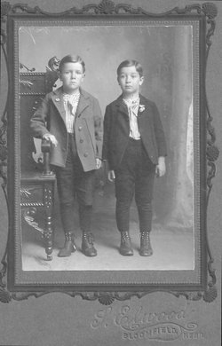
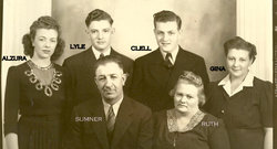

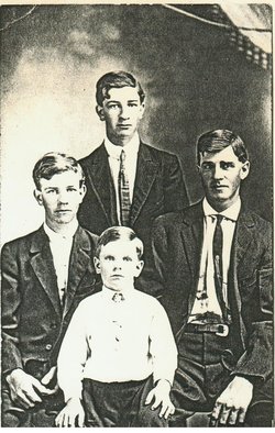

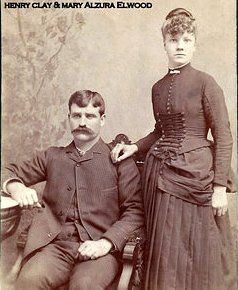
Clay Sumner Elwood
| Birth | : | 22 Jul 1899 Creighton, Knox County, Nebraska, USA |
| Death | : | 20 Jul 1955 Gordon, Sheridan County, Nebraska, USA |
| Burial | : | Gordon Cemetery, Gordon, Sheridan County, USA |
| Coordinate | : | 42.7858009, -102.2102966 |
| Description | : | RITES HELD AT GORDON FOR FORMER RESIDENT Funeral services were held last Friday, July 22 for Clay Sumner Elwood, former Creighton resident and a brother of Mrs. D.A. Van Deveer, Mrs. Alta Fricke and Lyman Elwood of Creighton. Masonic rites were conducted at Gordon and interment was there also. Clay Sumner Elwood was born July 22, 1899 at Creighton to Mr. and Mrs. H.C. Elwood and died at his home in Gordon July 20 just two days before his 56th birthday anniversary. He grew to manhood in this vicinity and was united in marriage to Ruth Ann Koresky of Creighton April 16, 1918.... Read More |
frequently asked questions (FAQ):
-
Where is Clay Sumner Elwood's memorial?
Clay Sumner Elwood's memorial is located at: Gordon Cemetery, Gordon, Sheridan County, USA.
-
When did Clay Sumner Elwood death?
Clay Sumner Elwood death on 20 Jul 1955 in Gordon, Sheridan County, Nebraska, USA
-
Where are the coordinates of the Clay Sumner Elwood's memorial?
Latitude: 42.7858009
Longitude: -102.2102966
Family Members:
Parent
Spouse

Siblings


Children
Flowers:


Nearby Cemetories:
1. Gordon Cemetery
Gordon, Sheridan County, USA
Coordinate: 42.7858009, -102.2102966
2. Mount Hope Cemetery
Gordon, Sheridan County, USA
Coordinate: 42.7113991, -102.2241974
3. Dane Cemetery
Cherry County, USA
Coordinate: 42.7924300, -102.0824700
4. Bethel Cemetery
Sheridan County, USA
Coordinate: 42.9011002, -102.3208008
5. Lavaca Cemetery
Irwin, Cherry County, USA
Coordinate: 42.7332993, -102.0175018
6. Amity Cemetery
Sheridan County, USA
Coordinate: 42.8036003, -102.4389038
7. Fair View Cemetery
Rushville, Sheridan County, USA
Coordinate: 42.7155991, -102.4325027
8. Saint Aloysius Cemetery
Sheridan County, USA
Coordinate: 42.9015500, -102.4025500
9. Saint Marys Cemetery
Rushville, Sheridan County, USA
Coordinate: 42.7174988, -102.4436035
10. Feather on Head Cemetery
Oglala Lakota County, USA
Coordinate: 43.0311012, -102.1611023
11. Holly Cemetery
Rushville, Sheridan County, USA
Coordinate: 42.8575120, -102.5370990
12. Novotny Cemetery
Hay Springs, Sheridan County, USA
Coordinate: 42.7742004, -102.5963974
13. Davis Cemetery
Rushville, Sheridan County, USA
Coordinate: 42.5421000, -102.4118800
14. Wolf Creek Community Cemetery
Oglala Lakota County, USA
Coordinate: 43.0405750, -102.3966490
15. Spotted Bear Family Cemetery
Denby, Oglala Lakota County, USA
Coordinate: 43.0608200, -102.3376600
16. Preble Cemetery
Sheridan County, USA
Coordinate: 42.6504000, -102.5765000
17. Abold Family Cemetery
Rushville, Sheridan County, USA
Coordinate: 42.8863500, -102.6158000
18. Bomar Cemetery
Hay Springs, Sheridan County, USA
Coordinate: 42.8062000, -102.6459600
19. Native American Cemetery
Oglala, Oglala Lakota County, USA
Coordinate: 43.0886002, -102.3550034
20. White Clay Cemetery
Rushville, Sheridan County, USA
Coordinate: 42.9732820, -102.5667230
21. Knight Cemetery
Oglala Lakota County, USA
Coordinate: 43.1039009, -102.1200027
22. Holy Cross Cemetery
Pine Ridge, Oglala Lakota County, USA
Coordinate: 43.0194016, -102.5503006
23. Pine Ridge Presbyterian Cemetery
Pine Ridge, Oglala Lakota County, USA
Coordinate: 43.0235200, -102.5506200
24. Beguin Cemetery
Sheridan County, USA
Coordinate: 42.5107994, -102.4982986