
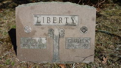
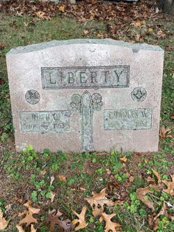
Ruth Carolyn Phinney Liberty
| Birth | : | 18 Aug 1906 Bourne, Barnstable County, Massachusetts, USA |
| Death | : | Oct 1953 Wareham, Plymouth County, Massachusetts, USA |
| Burial | : | Monument Neck Cemetery, Gray Gables, Barnstable County, USA |
| Coordinate | : | 41.7346001, -70.6128006 |
| Description | : | Daughter of James Winslow Phinney and Mildred L. Raymond [born 1884 in Sandwich; daughter of Fred Raymond and Carrie B. Rogers] who were married in 1902 in Bourne, MA. Mildred married 2nd to Seymore C. Stewart in 1916 in Bourne, MA. Seymore died in 1929. She married 3rd to George Nuttall in 1941 in Malden, MA. Ruth was married 1st to unknown Leonard between 1920 and 1930. She is listed as divorced in the 1940 census. She died as the result of a car accident that took place in Sandwich, MA. |
frequently asked questions (FAQ):
-
Where is Ruth Carolyn Phinney Liberty's memorial?
Ruth Carolyn Phinney Liberty's memorial is located at: Monument Neck Cemetery, Gray Gables, Barnstable County, USA.
-
When did Ruth Carolyn Phinney Liberty death?
Ruth Carolyn Phinney Liberty death on Oct 1953 in Wareham, Plymouth County, Massachusetts, USA
-
Where are the coordinates of the Ruth Carolyn Phinney Liberty's memorial?
Latitude: 41.7346001
Longitude: -70.6128006
Family Members:
Parent

Spouse

Flowers:


Nearby Cemetories:
1. Monument Neck Cemetery
Gray Gables, Barnstable County, USA
Coordinate: 41.7346001, -70.6128006
2. Oakland Grove Cemetery
Bourne, Barnstable County, USA
Coordinate: 41.7402992, -70.6042023
3. Old Bourne Cemetery
Bourne, Barnstable County, USA
Coordinate: 41.7386017, -70.5986023
4. Bourne Village Cemetery
Bourne, Barnstable County, USA
Coordinate: 41.7425117, -70.5938110
5. Bourne Family Cemetery
Bourne, Barnstable County, USA
Coordinate: 41.7501602, -70.6032104
6. Monument Beach Cemetery
Monument Beach, Barnstable County, USA
Coordinate: 41.7151800, -70.6094600
7. Long Neck Cemetery
Wareham, Plymouth County, USA
Coordinate: 41.7461014, -70.6369019
8. Bourne Family Cemetery #02
Bourne, Barnstable County, USA
Coordinate: 41.7577230, -70.6001190
9. Nickerson Burial Ground
Plymouth, Plymouth County, USA
Coordinate: 41.7642740, -70.6306530
10. Pocasset Cemetery
Bourne, Barnstable County, USA
Coordinate: 41.6947260, -70.6034070
11. Bournedale Burying Hill
Bourne, Barnstable County, USA
Coordinate: 41.7741520, -70.5611730
12. Cataumet Cemetery
Bourne, Barnstable County, USA
Coordinate: 41.6768990, -70.6063995
13. Agawam Cemetery
Wareham, Plymouth County, USA
Coordinate: 41.7463989, -70.6908035
14. Bournedale Herring Pond Indian Cemetery
Bourne, Barnstable County, USA
Coordinate: 41.7861900, -70.5658722
15. Herring Pond Wampanoag Indian Cemetery
Plymouth, Plymouth County, USA
Coordinate: 41.7867290, -70.5658940
16. Massachusetts National Cemetery
Bourne, Barnstable County, USA
Coordinate: 41.6759987, -70.5824966
17. Sagamore Cemetery
Bourne, Barnstable County, USA
Coordinate: 41.7714005, -70.5339966
18. Herring Pond Cemetery
Plymouth, Plymouth County, USA
Coordinate: 41.7971700, -70.5588800
19. Amrita Island Mausoleum
Bourne, Barnstable County, USA
Coordinate: 41.6593900, -70.6207900
20. Saddle and Pillion Cemetery
Sagamore, Barnstable County, USA
Coordinate: 41.7672005, -70.5192032
21. Saint Peters Cemetery
Sandwich, Barnstable County, USA
Coordinate: 41.7502480, -70.5079346
22. Bay View Cemetery
Sandwich, Barnstable County, USA
Coordinate: 41.7583008, -70.5102997
23. Freeman Cemetery
Sandwich, Barnstable County, USA
Coordinate: 41.7573013, -70.5083008
24. Otis Memorial
Bourne, Barnstable County, USA
Coordinate: 41.6596980, -70.5706980