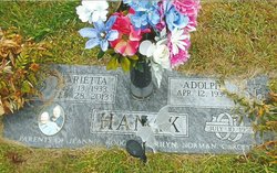
| Birth | : | 24 Dec 1927 Leigh, Colfax County, Nebraska, USA |
| Death | : | 4 Oct 2003 Lincoln, Lancaster County, Nebraska, USA |
| Burial | : | Västra Ingelstad Gamla Kyrkogård, Vastra Ingelstad, Vellinge kommun, Sweden |
| Coordinate | : | 55.4903430, 13.1168530 |
| Description | : | Daughter of Joseph & Kathe (Correll) Hanak. She married Miles Hoffman on October 26, 1947 at St. Peter's Lutheran Church in Creston. She lived most of her married life in Columbus. She was a homemaker and worked at Dale Electronics. Ruth enjoyed visiting friends and family. She was a member of St. Luke's Congregational Church-UCC, and the VFW Auxiliary. She is survived by: Daughter: Charlene Davis of Omaha, NE Daughter: Charlotte (Roger) Meyer of Omaha, NE Son: David (Deb) Hoffman of Ashland, NE Son: Donald (Brenna) Hoffman of Omaha, NE Son: James (Karen) Hoffman of Ashland, NE Son: Robert (Mary) Hoffman of Omaha, NE... Read More |
frequently asked questions (FAQ):
-
Where is Ruth E. Hanak Hoffman's memorial?
Ruth E. Hanak Hoffman's memorial is located at: Västra Ingelstad Gamla Kyrkogård, Vastra Ingelstad, Vellinge kommun, Sweden.
-
When did Ruth E. Hanak Hoffman death?
Ruth E. Hanak Hoffman death on 4 Oct 2003 in Lincoln, Lancaster County, Nebraska, USA
-
Where are the coordinates of the Ruth E. Hanak Hoffman's memorial?
Latitude: 55.4903430
Longitude: 13.1168530
Family Members:
Parent
Spouse
Siblings
Flowers:
Nearby Cemetories:
1. Västra Ingelstad Gamla Kyrkogård
Vastra Ingelstad, Vellinge kommun, Sweden
Coordinate: 55.4903430, 13.1168530
2. Västra Ingelstad Nya Kyrkogård
Vellinge, Vellinge kommun, Sweden
Coordinate: 55.4903817, 13.1168721
3. Västra Ingelstads Kyrkogård
Vellinge, Vellinge kommun, Sweden
Coordinate: 55.4902806, 13.1160125
4. Mellan-Grevie Kyrkogård
Mellan-Grevie, Vellinge kommun, Sweden
Coordinate: 55.4700912, 13.0970274
5. Östra Grevie Kyrkogård
Ostra Grevie, Vellinge kommun, Sweden
Coordinate: 55.4690915, 13.1349324
6. Arrie Kyrkogård
Vellinge, Vellinge kommun, Sweden
Coordinate: 55.5153062, 13.0848378
7. Södra Åkarp Kyrkogård
Sodra Akarp, Vellinge kommun, Sweden
Coordinate: 55.4840714, 13.0510117
8. Hököpinge Nya Kyrkogård
Vellinge, Vellinge kommun, Sweden
Coordinate: 55.5013195, 13.0323886
9. Hököpinge Gamla Kyrkogård
Vellinge, Vellinge kommun, Sweden
Coordinate: 55.5025990, 13.0297430
10. Eskilstorps Kyrkogård
Vellinge, Vellinge kommun, Sweden
Coordinate: 55.4804669, 13.0234034
11. Vellinge Nya Kyrkogård
Vellinge, Vellinge kommun, Sweden
Coordinate: 55.4655504, 13.0196800
12. Gessie Gamla Kyrkogård
Vellinge, Vellinge kommun, Sweden
Coordinate: 55.5018556, 12.9968000
13. Flädie Cemetery
Lomma kommun, Sweden
Coordinate: 55.4333000, 13.0413000
14. Gessie Nya Kyrkogård
Gessie, Vellinge kommun, Sweden
Coordinate: 55.5017280, 12.9882270
15. Trelleborg Northern Cemetery
Trelleborg, Trelleborgs kommun, Sweden
Coordinate: 55.3836510, 13.1555700
16. Norra Kyrkogården
Trelleborg, Trelleborgs kommun, Sweden
Coordinate: 55.3832200, 13.1576600
17. Östra Kyrkogården
Malmö, Malmö kommun, Sweden
Coordinate: 55.5936110, 13.0452780
18. Bara Kyrkogård
Svedala kommun, Sweden
Coordinate: 55.5909233, 13.2014502
19. Bara Ödekyrkogård
Svedala kommun, Sweden
Coordinate: 55.5909945, 13.2017832
20. Bösarp Cemetery
Trelleborgs kommun, Sweden
Coordinate: 55.4117024, 13.2617568
21. Hyllie kyrkogård
Malmö kommun, Sweden
Coordinate: 55.5663535, 12.9632980
22. Sankt Pauli Mellersta Kyrkogård
Malmö, Malmö kommun, Sweden
Coordinate: 55.5976730, 13.0202500
23. Malmo Jewish Cemetery
Malmö, Malmö kommun, Sweden
Coordinate: 55.6023100, 13.0186500
24. Limhamns Kyrkogård
Malmö, Malmö kommun, Sweden
Coordinate: 55.5726990, 12.9453440


