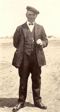
| Birth | : | 22 Dec 1878 What Cheer, Keokuk County, Iowa, USA |
| Death | : | 16 Apr 1942 Miller, Hand County, South Dakota, USA |
| Burial | : | G A R Cemetery, Miller, Hand County, USA |
| Coordinate | : | 44.5078011, -98.9858017 |
| Plot | : | Block 4 Lot 27 Grave 2 |
| Description | : | South Dakota Marriages Mrs. Ruth Estella Conkey married Milo Brown, 20 March 1929 at Huron, Beadle, South Dakota. She was a widow and he was divorced. Both were residents of St. Lawrence. ~~~~~~~~~ South Dakota Death Index Ruth E. Brown, 16 April 1942, Hand County. ~~~~~~~~~ Death Removes Pioneer Lady Stroke Is Fatal To Mrs. Estella Brown. Burial Rites Sunday Mrs. Estella Brown, resident of Hand county since 1886, passed away last Thursday afternoon from the effects of a stroke. Her death occurred only a short time after she was brought to the... Read More |
frequently asked questions (FAQ):
-
Where is Ruth Estella Carl Conkey Brown's memorial?
Ruth Estella Carl Conkey Brown's memorial is located at: G A R Cemetery, Miller, Hand County, USA.
-
When did Ruth Estella Carl Conkey Brown death?
Ruth Estella Carl Conkey Brown death on 16 Apr 1942 in Miller, Hand County, South Dakota, USA
-
Where are the coordinates of the Ruth Estella Carl Conkey Brown's memorial?
Latitude: 44.5078011
Longitude: -98.9858017
Family Members:
Parent
Spouse
Siblings
Flowers:
Nearby Cemetories:
1. G A R Cemetery
Miller, Hand County, USA
Coordinate: 44.5078011, -98.9858017
2. Hillcrest Cemetery
Miller, Hand County, USA
Coordinate: 44.5207000, -99.0006100
3. Saint Ann's Cemetery
Miller, Hand County, USA
Coordinate: 44.5222015, -98.9732971
4. Saint Lawrence Cemetery
Saint Lawrence, Hand County, USA
Coordinate: 44.5292015, -98.9321976
5. Morningside Cemetery
Ree Heights, Hand County, USA
Coordinate: 44.5147018, -99.1903000
6. Beulah Cemetery
Vayland, Hand County, USA
Coordinate: 44.6060982, -98.8060989
7. Alden Cemetery
Hand County, USA
Coordinate: 44.6775017, -99.1203003
8. Sunbeam Cemetery
Hand County, USA
Coordinate: 44.6777992, -98.8407974
9. Wessington Cemetery
Hand County, USA
Coordinate: 44.4569016, -98.7102966
10. Saint Josephs Catholic Cemetery
Hand County, USA
Coordinate: 44.4574400, -98.7100400
11. Burdette Cemetery
Burdette, Hand County, USA
Coordinate: 44.7002983, -98.7869034
12. McCord Cemetery
Wessington, Beadle County, USA
Coordinate: 44.3998500, -98.6673100
13. Rosehill Cemetery
Hand County, USA
Coordinate: 44.2980995, -98.7731018
14. Howell Cemetery
Miller, Hand County, USA
Coordinate: 44.7757988, -98.9766998
15. Buffalo Cemetery
Spink County, USA
Coordinate: 44.6918983, -98.6853027
16. Cedar Cemetery
Hand County, USA
Coordinate: 44.2775002, -99.2238998
17. Mount Calvary Cemetery
Polo, Hand County, USA
Coordinate: 44.7827988, -99.1097031
18. Sand Creek Cemetery
Beadle County, USA
Coordinate: 44.3055800, -98.6791200
19. Ebenezer Baptist Cemetery
Hand County, USA
Coordinate: 44.2106018, -98.9056015
20. Mondamin Cemetery
Hand County, USA
Coordinate: 44.2158012, -99.1238022
21. Highmore Cemetery
Highmore, Hyde County, USA
Coordinate: 44.5074997, -99.4197006
22. Saint Marys Catholic Cemetery
Highmore, Hyde County, USA
Coordinate: 44.5063800, -99.4214900
23. Saint Johns Cemetery
Tulare, Spink County, USA
Coordinate: 44.7202988, -98.6600037
24. New Zion Cemetery
Hand County, USA
Coordinate: 44.2043991, -98.8206024


