
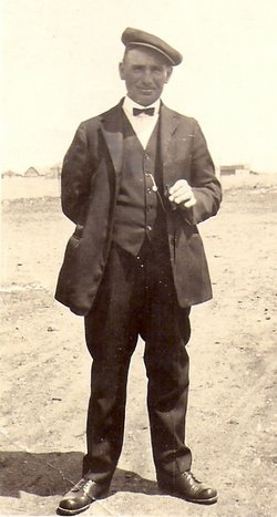
| Birth | : | 23 Feb 1877 What Cheer, Keokuk County, Iowa, USA |
| Death | : | 20 Sep 1946 Saint Lawrence, Hand County, South Dakota, USA |
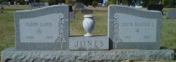
| Burial | : | Salem Christian Union Church Cemetery, Excelsior Springs, Clay County, USA |
| Coordinate | : | 39.3766708, -94.2157745 |
| Plot | : | Block 4, Lot 27 |
| Description | : | Death Summons Mrs. Allen Jones County Pioneer Ill for about a month, Mrs. Allen Jones, 69, passed away last Friday at the Miller hospital. Taken ill on August 24, she was removed to the hospital and on September 11 submitted to an operation in hope of prolonging her life. For several days she showed some improvement, but suffered a relapse a few days before her death. Funeral services were held on Monday afternoon from the Community church in St. Lawrence, and were in charge of Rev. N.A. Luke and Rev. Harry Ernst. Pallbearers were Ted... Read More |
frequently asked questions (FAQ):
-
Where is Emma Melissa Carl Jones's memorial?
Emma Melissa Carl Jones's memorial is located at: Salem Christian Union Church Cemetery, Excelsior Springs, Clay County, USA.
-
When did Emma Melissa Carl Jones death?
Emma Melissa Carl Jones death on 20 Sep 1946 in Saint Lawrence, Hand County, South Dakota, USA
-
Where are the coordinates of the Emma Melissa Carl Jones's memorial?
Latitude: 39.3766708
Longitude: -94.2157745
Family Members:
Parent

Spouse
Siblings
Children
Flowers:


Nearby Cemetories:
1. Salem Christian Union Church Cemetery
Excelsior Springs, Clay County, USA
Coordinate: 39.3766708, -94.2157745
2. John Jack Crowley Graveyard
Clay County, USA
Coordinate: 39.3659167, -94.2566111
3. Hamers Farm Cemetery
Ray County, USA
Coordinate: 39.3560400, -94.1762900
4. Majors Family Cemetery
Excelsior Springs, Clay County, USA
Coordinate: 39.4042358, -94.2513657
5. Crown Hill Cemetery
Excelsior Springs, Clay County, USA
Coordinate: 39.3446999, -94.2474976
6. Masonic Cemetery
Excelsior Springs, Clay County, USA
Coordinate: 39.3432655, -94.2482910
7. Crowley Cemetery
Vibbard, Ray County, USA
Coordinate: 39.3807793, -94.1616745
8. Cox Cemetery
Wood Heights, Ray County, USA
Coordinate: 39.3368988, -94.1819000
9. Watkins Mill Cemetery
Clay County, USA
Coordinate: 39.4106800, -94.2603200
10. Elmwood Cemetery
Excelsior Springs, Clay County, USA
Coordinate: 39.3353004, -94.2485962
11. Pisgah Cemetery
Wood Heights, Ray County, USA
Coordinate: 39.3376846, -94.1775055
12. Clevenger Cemetery
Crystal Lakes, Ray County, USA
Coordinate: 39.3600006, -94.1560974
13. John Cleavenger Cemetery
Crystal Lakes, Ray County, USA
Coordinate: 39.3551407, -94.1542053
14. John Clevenger Cemetery
Crystal Lakes, Ray County, USA
Coordinate: 39.3551300, -94.1540600
15. Hollingsworth Family Cemetery
Excelsior Springs, Clay County, USA
Coordinate: 39.4293940, -94.2230050
16. Hillcrest Cemetery
Excelsior Springs, Clay County, USA
Coordinate: 39.3358002, -94.2619019
17. McKee-Moore Cemetery
Clay County, USA
Coordinate: 39.3315630, -94.2608620
18. Bethel Cemetery
Kearney, Clay County, USA
Coordinate: 39.3744011, -94.2902985
19. Welton Cemetery
Clay County, USA
Coordinate: 39.3292800, -94.2663300
20. Lawson Cemetery
Lawson, Ray County, USA
Coordinate: 39.4368248, -94.1954880
21. North New Garden Primitive Baptist Church Cemetery
Wood Heights, Ray County, USA
Coordinate: 39.3271027, -94.1648026
22. Windy Hill Cemetery
Wood Heights, Ray County, USA
Coordinate: 39.3407364, -94.1462250
23. Old New Garden Primitive Baptist Cemetery
Wood Heights, Ray County, USA
Coordinate: 39.3227005, -94.1669006
24. Shady Grove Cemetery
Kearney, Clay County, USA
Coordinate: 39.3605995, -94.3003006