

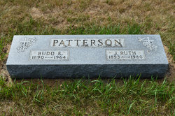
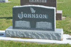
Ruth Irene Patterson Johnson
| Birth | : | 8 Sep 1918 Stratford, Hamilton County, Iowa, USA |
| Death | : | 15 Mar 2014 Boone, Boone County, Iowa, USA |
| Burial | : | South Marion Cemetery, Stratford, Hamilton County, USA |
| Coordinate | : | 42.2327995, -93.8735962 |
| Description | : | Ruth Irene (Patterson) Johnson, 95, of the Eastern Star Masonic Home in Boone and formerly of Stratford, Iowa passed away at the Home on Saturday morning, March 15, 2014 following a brief illness in the loving presence of family members. Irene was born at home in rural Stratford, Iowa on September 8, 1918, the second daughter of Budd E. Patterson and Jennie Ruth (Swedlund) Patterson. She grew up on her parents’ farm, walked to country school, and graduated from Stratford High School in 1936. She married Lester R. Johnson on March 7, 1943, in her parents’ home.... Read More |
frequently asked questions (FAQ):
-
Where is Ruth Irene Patterson Johnson's memorial?
Ruth Irene Patterson Johnson's memorial is located at: South Marion Cemetery, Stratford, Hamilton County, USA.
-
When did Ruth Irene Patterson Johnson death?
Ruth Irene Patterson Johnson death on 15 Mar 2014 in Boone, Boone County, Iowa, USA
-
Where are the coordinates of the Ruth Irene Patterson Johnson's memorial?
Latitude: 42.2327995
Longitude: -93.8735962
Family Members:
Parent

Spouse
Siblings
Flowers:


Nearby Cemetories:
1. South Marion Cemetery
Stratford, Hamilton County, USA
Coordinate: 42.2327995, -93.8735962
2. Oakwood Cemetery
Stratford, Hamilton County, USA
Coordinate: 42.2942009, -93.9182968
3. Mineral Ridge Cemetery
Ridgeport, Boone County, USA
Coordinate: 42.1749992, -93.9266968
4. Hooks Point Cemetery
Hamilton County, USA
Coordinate: 42.2944530, -93.9199090
5. Hardin Township Cemetery
Hardin Township, Webster County, USA
Coordinate: 42.2411003, -93.9708023
6. Saint Paul Lutheran Cemetery
Boone, Boone County, USA
Coordinate: 42.1700000, -93.8070000
7. Boone County Poor Farm Cemetery
Boone County, USA
Coordinate: 42.1591100, -93.9159000
8. White Cemetery
Boone County, USA
Coordinate: 42.1777992, -93.9636002
9. Lake Center Cemetery
Stanhope, Hamilton County, USA
Coordinate: 42.2482986, -93.7568970
10. Leininger Cemetery
Boone County, USA
Coordinate: 42.1492004, -93.8356018
11. Lawn Hill Cemetery
Stanhope, Hamilton County, USA
Coordinate: 42.2677994, -93.7611008
12. Nesse Cemetery
Hamilton County, USA
Coordinate: 42.3250008, -93.8933029
13. Neese Cemetery
Homer, Hamilton County, USA
Coordinate: 42.3250000, -93.8935000
14. Linn Cemetery
Pilot Mound, Boone County, USA
Coordinate: 42.2045330, -93.9970230
15. Vegors Cemetery
Webster County, USA
Coordinate: 42.3177986, -93.9421997
16. Mackey Cemetery
Boone County, USA
Coordinate: 42.1675000, -93.7565000
17. Runyan Cemetery
Pilot Mound, Boone County, USA
Coordinate: 42.1749992, -94.0015030
18. Saint Pauls Church Cemetery
Jewell, Hamilton County, USA
Coordinate: 42.2490100, -93.7173400
19. Schlicht Cemetery
Fraser, Boone County, USA
Coordinate: 42.1444200, -93.9780100
20. Bass Cemetery
Dayton, Webster County, USA
Coordinate: 42.2966995, -94.0149994
21. Saratoga Cemetery
Stanhope, Hamilton County, USA
Coordinate: 42.3539009, -93.8167038
22. Pilot Mound Cemetery
Pilot Mound, Boone County, USA
Coordinate: 42.1636200, -94.0282600
23. Ellsworth Clear Lake Cemetery
Randall, Hamilton County, USA
Coordinate: 42.2268930, -93.6926200
24. Bass Point Cemetery
Boone, Boone County, USA
Coordinate: 42.0992012, -93.8957977