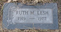
Ruth Mable Beatty Lesh
| Birth | : | 20 Aug 1919 Havre, Hill County, Montana, USA |
| Death | : | 8 Oct 1977 Billings, Yellowstone County, Montana, USA |
| Burial | : | Woodland Cemetery and Arboretum, Dayton, Montgomery County, USA |
| Coordinate | : | 39.7428840, -84.1773210 |
| Plot | : | Section 3-B |
| Description | : | Great Falls Tribune Oct 10, 1977 Ruth M. Lesh, 58, Great Falls, died Saturday afternoon in a Billings hospital. She had been in Billings the past month visiting her daughter. Mrs. Lesh was born in Havre and had resided several years in Great Falls. Her husband, Joseph Lesh, who was employed 33 years with the Great Northern Railroad, died in September, 1971. She is survived by a daughter, a son, three sisters, three brothers and five grandchildren. |
frequently asked questions (FAQ):
-
Where is Ruth Mable Beatty Lesh's memorial?
Ruth Mable Beatty Lesh's memorial is located at: Woodland Cemetery and Arboretum, Dayton, Montgomery County, USA.
-
When did Ruth Mable Beatty Lesh death?
Ruth Mable Beatty Lesh death on 8 Oct 1977 in Billings, Yellowstone County, Montana, USA
-
Where are the coordinates of the Ruth Mable Beatty Lesh's memorial?
Latitude: 39.7428840
Longitude: -84.1773210
Family Members:
Parent
Spouse
Siblings
Flowers:
Nearby Cemetories:
1. Woodland Cemetery and Arboretum
Dayton, Montgomery County, USA
Coordinate: 39.7428840, -84.1773210
2. Marianist Brothers Cemetery
Dayton, Montgomery County, USA
Coordinate: 39.7385700, -84.1733500
3. Saint Henrys Cemetery
Dayton, Montgomery County, USA
Coordinate: 39.7450150, -84.1887630
4. Riverview Cemetery
Dayton, Montgomery County, USA
Coordinate: 39.7299995, -84.1908035
5. Beth Abraham Cemetery
Oakwood, Montgomery County, USA
Coordinate: 39.7291985, -84.1919022
6. Dayton Presbyterian and Methodist Graveyard (Defun
Dayton, Montgomery County, USA
Coordinate: 39.7558670, -84.1933820
7. Saint Paul's Episcopal Church Columbarium
Oakwood, Montgomery County, USA
Coordinate: 39.7249780, -84.1747480
8. Christ Episcopal Church Columbarium
Dayton, Montgomery County, USA
Coordinate: 39.7620240, -84.1937090
9. Calvary Cemetery
Dayton, Montgomery County, USA
Coordinate: 39.7248993, -84.1979980
10. Old Greencastle Cemetery
Dayton, Montgomery County, USA
Coordinate: 39.7370000, -84.2143900
11. New Greencastle Cemetery
Dayton, Montgomery County, USA
Coordinate: 39.7346992, -84.2272034
12. Saint Marks Episcopal Church Memorial Garden
Riverside, Montgomery County, USA
Coordinate: 39.7601350, -84.1199190
13. Kemp Cemetery
Riverside, Montgomery County, USA
Coordinate: 39.7636940, -84.1192250
14. Westmont Cemetery
Dayton, Montgomery County, USA
Coordinate: 39.7247009, -84.2453003
15. Zion Cemetery
Moraine, Montgomery County, USA
Coordinate: 39.6931877, -84.2118378
16. Cook Cemetery
Dayton, Montgomery County, USA
Coordinate: 39.7980995, -84.1605988
17. Beavertown Cemetery
Beavertown, Montgomery County, USA
Coordinate: 39.6981010, -84.1288986
18. Harshman Cemetery
Riverside, Montgomery County, USA
Coordinate: 39.7800369, -84.1177139
19. Kinsey-Wolf Family Cemetery
Dayton, Montgomery County, USA
Coordinate: 39.7405220, -84.2540900
20. Willow View Cemetery
Dayton, Montgomery County, USA
Coordinate: 39.8022003, -84.1819000
21. Union Cemetery
Dayton, Montgomery County, USA
Coordinate: 39.8031998, -84.1794128
22. Dayton National Cemetery
Dayton, Montgomery County, USA
Coordinate: 39.7482224, -84.2591705
23. Davids Cemetery
Kettering, Montgomery County, USA
Coordinate: 39.6789017, -84.1697006
24. Retter Harshman Property Gravesite
Beavercreek, Greene County, USA
Coordinate: 39.7576000, -84.0951400

