

Ruth McMillin Long Ellis
| Birth | : | 25 Mar 1905 Enon, Moniteau County, Missouri, USA |
| Death | : | 11 Dec 2001 Eldon, Miller County, Missouri, USA |
| Burial | : | Enloe Cemetery, Moniteau County, USA |
| Coordinate | : | 38.5074997, -92.4741974 |
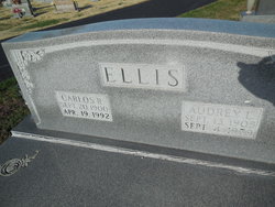
| Description | : | Jefferson City Post-Tribune, Wednesday, December 12, 2001 Ruth Long McMillin Ellis, 96, Eldon, died Dec. 11, 2001, in Eldon. She was born March 25, 1905 in Enon, a daughter of Charley and Florence Machett Long. She was married April 8, 1925, to Floyd McMillin, who died July 10, 1968. She was married Nov. 28, 1979, to Carlos Ellis, who died April 19, 1992. She was a member of the Greenridge Baptist Church in Eldon. She was a homemaker. Survivors include: two sons, Floyd Ouderkirk, Barnett and Wes Ouderkirk, Higginsville. Services will be at 2:30... Read More |
frequently asked questions (FAQ):
-
Where is Ruth McMillin Long Ellis's memorial?
Ruth McMillin Long Ellis's memorial is located at: Enloe Cemetery, Moniteau County, USA.
-
When did Ruth McMillin Long Ellis death?
Ruth McMillin Long Ellis death on 11 Dec 2001 in Eldon, Miller County, Missouri, USA
-
Where are the coordinates of the Ruth McMillin Long Ellis's memorial?
Latitude: 38.5074997
Longitude: -92.4741974
Family Members:
Spouse


Nearby Cemetories:
1. Enloe Cemetery
Moniteau County, USA
Coordinate: 38.5074997, -92.4741974
2. Belleville Cemetery
Russellville, Cole County, USA
Coordinate: 38.4970490, -92.4667150
3. Enon Cemetery
Russellville, Cole County, USA
Coordinate: 38.4888992, -92.4730988
4. Karnes-Carney-Henderson Cemetery
Burris Fork, Moniteau County, USA
Coordinate: 38.4992100, -92.5007510
5. Saint Michael Cemetery
Russellville, Cole County, USA
Coordinate: 38.5109300, -92.4429100
6. Evangelical Lutheran Cemetery One Acre
Russellville, Cole County, USA
Coordinate: 38.5175667, -92.4415817
7. Buckner Russell Cemetery
Cole County, USA
Coordinate: 38.5136900, -92.4359390
8. Van Pool Cemetery
Moniteau County, USA
Coordinate: 38.5372009, -92.4627991
9. Russellville Cemetery
Russellville, Cole County, USA
Coordinate: 38.5196991, -92.4366989
10. Trinity Lutheran Cemetery
Russellville, Cole County, USA
Coordinate: 38.5028000, -92.4317017
11. Karnes Cemetery
Corticelli, Moniteau County, USA
Coordinate: 38.5099700, -92.5247900
12. Campbell Cemetery
Cole County, USA
Coordinate: 38.4810982, -92.4297028
13. Blank Cemetery
Russellville, Cole County, USA
Coordinate: 38.5203018, -92.4180984
14. DeFoe Cemetery
California, Moniteau County, USA
Coordinate: 38.5416985, -92.5250015
15. Rock Enon Cemetery
Miller County, USA
Coordinate: 38.4668400, -92.5170700
16. Bruce-Lewis-McGahan Cemetery
Enon, Moniteau County, USA
Coordinate: 38.4667500, -92.5172100
17. Roark Cemetery
Russellville, Cole County, USA
Coordinate: 38.4696999, -92.4255981
18. Matheis Cemetery
Russellville, Cole County, USA
Coordinate: 38.4571800, -92.4491600
19. Barnhardt Cemetery
Lohman, Cole County, USA
Coordinate: 38.5537900, -92.4267100
20. Clibourn Cemetery
Russellville, Cole County, USA
Coordinate: 38.4760500, -92.3973500
21. Marney Family Cemetery
High Point, Moniteau County, USA
Coordinate: 38.5357900, -92.5614500
22. Jackson Chapel Methodist Church Cemetery
California, Moniteau County, USA
Coordinate: 38.4447900, -92.5286500
23. Yarnell Cemetery
California, Moniteau County, USA
Coordinate: 38.5189018, -92.5708008
24. Gray Cemetery
Moniteau County, USA
Coordinate: 38.4536018, -92.5456009