
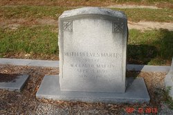
Ruth Reeves Martin
| Birth | : | 3 Sep 1893 Orangeburg County, South Carolina, USA |
| Death | : | 2 Nov 1988 Branchville, Orangeburg County, South Carolina, USA |
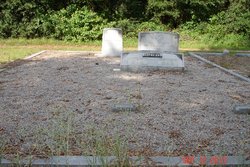
| Burial | : | Rutland Rural Cemetery, Rutland, Worcester County, USA |
| Coordinate | : | 42.3790100, -71.9447500 |
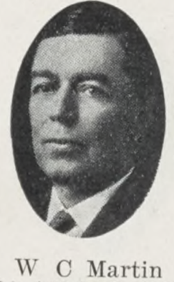
| Inscription | : | Wife Of. W.Claude Martin. |
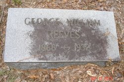
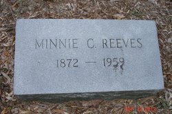
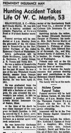
| Description | : | Branchville - Mrs. Ruth Reeves Martin, 85, widow of Sen. W. Claude Martin, died Wednesday. Born in Orangeburg County, she was a daughter of the late George William and Mrs. Minnie Myers Reeves and was a member of Orangeburg Presbyterian Church. Surviving are a son, Dr. George E. Martin of Falls Church, Va.; and daughters, Mrs. C. L. Fishburn of the Still Hopes Episcopal Retirement Community of West Columbia and Mrs. Delbert Howell of Anderson. Services will be held at 11 a.m. today at Ott Funeral Home Chapel of Branchville, with burial in Ott Cemetery. The State, Columbia, SC,... Read More |
frequently asked questions (FAQ):
-
Where is Ruth Reeves Martin's memorial?
Ruth Reeves Martin's memorial is located at: Rutland Rural Cemetery, Rutland, Worcester County, USA.
-
When did Ruth Reeves Martin death?
Ruth Reeves Martin death on 2 Nov 1988 in Branchville, Orangeburg County, South Carolina, USA
-
Where are the coordinates of the Ruth Reeves Martin's memorial?
Latitude: 42.3790100
Longitude: -71.9447500
Family Members:
Parent
Spouse
Siblings
Children

Flowers:


Nearby Cemetories:
1. Rutland Rural Cemetery
Rutland, Worcester County, USA
Coordinate: 42.3790100, -71.9447500
2. Old Burial Ground
Rutland, Worcester County, USA
Coordinate: 42.3756000, -71.9578000
3. Smith Family Cemetery
Rutland, Worcester County, USA
Coordinate: 42.3946064, -71.9231169
4. Putnam Farm Cemetery
Rutland, Worcester County, USA
Coordinate: 42.3484010, -71.9771420
5. Goose Hill Cemetery
Rutland, Worcester County, USA
Coordinate: 42.3997400, -71.9914000
6. West Rutland Cemetery
Rutland, Worcester County, USA
Coordinate: 42.3561970, -71.9897170
7. Rutland Prison Camp Cemetery
Rutland, Worcester County, USA
Coordinate: 42.3988500, -71.9923800
8. Mooreland Cemetery
Paxton, Worcester County, USA
Coordinate: 42.3280800, -71.9321000
9. South Burying Ground
Princeton, Worcester County, USA
Coordinate: 42.4192009, -71.8957977
10. Worcester County Memorial Park
Paxton, Worcester County, USA
Coordinate: 42.3245697, -71.9308777
11. Saint Mary Cemetery
Holden, Worcester County, USA
Coordinate: 42.3522400, -71.8684200
12. Grove Cemetery
Holden, Worcester County, USA
Coordinate: 42.3520400, -71.8672700
13. Green Hollow Cemetery
Oakham, Worcester County, USA
Coordinate: 42.3549995, -72.0243988
14. Park Avenue Cemetery
Holden, Worcester County, USA
Coordinate: 42.3514200, -71.8656900
15. Old Burying Ground
Holden, Worcester County, USA
Coordinate: 42.3505800, -71.8626000
16. Paxton Center Cemetery
Paxton, Worcester County, USA
Coordinate: 42.3128900, -71.9277700
17. West Cemetery
Princeton, Worcester County, USA
Coordinate: 42.4454100, -71.9256500
18. Saint Francis Episcopal Church Memorial Garden
Holden, Worcester County, USA
Coordinate: 42.3522800, -71.8588700
19. Parker Cemetery
Barre, Worcester County, USA
Coordinate: 42.4250800, -72.0240400
20. Oakham Center Cemetery
Oakham, Worcester County, USA
Coordinate: 42.3540000, -72.0421400
21. Route 62 Cemetery
Hubbardston, Worcester County, USA
Coordinate: 42.4426910, -72.0014980
22. South Cemetery
Oakham, Worcester County, USA
Coordinate: 42.3382988, -72.0374985
23. Woodlawn Cemetery
Princeton, Worcester County, USA
Coordinate: 42.4447260, -71.8835880
24. Coldbrook Cemetery
Barre, Worcester County, USA
Coordinate: 42.3944016, -72.0541992