
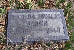
Sabria Matilda “Til” Latimer Brown
| Birth | : | 25 Dec 1850 Warsaw, Kosciusko County, Indiana, USA |
| Death | : | 27 Apr 1940 Holton, Jackson County, Kansas, USA |
| Burial | : | St. Paul's Anglican Churchyard, Kingston, Frontenac County, Canada |
| Coordinate | : | 44.2331467, -76.4850159 |
| Plot | : | Section 5 (west), Block 5, Lot 135 |
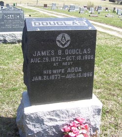
| Description | : | "Matilda, daughter of Francis and Rebecca Latimer, was born December 25, 1850, near Warsaw, Ind. When a young girl she moved to Illinois and later, in 1864, to Kansas. "At the age of 16 she was converted, baptized and united with the Baptist Church, to which she has always been a member. "In 1871 she was united in marriage to Jonathan D. Douglas. Five childre were born to this union, one son and four daughters. All have preceded her in death except Mrs. Dolly Landon, in whose home she passed away in quiet sleep April 27,... Read More |
frequently asked questions (FAQ):
-
Where is Sabria Matilda “Til” Latimer Brown's memorial?
Sabria Matilda “Til” Latimer Brown's memorial is located at: St. Paul's Anglican Churchyard, Kingston, Frontenac County, Canada.
-
When did Sabria Matilda “Til” Latimer Brown death?
Sabria Matilda “Til” Latimer Brown death on 27 Apr 1940 in Holton, Jackson County, Kansas, USA
-
Where are the coordinates of the Sabria Matilda “Til” Latimer Brown's memorial?
Latitude: 44.2331467
Longitude: -76.4850159
Family Members:
Parent
Spouse
Siblings

Children
Flowers:


Nearby Cemetories:
1. St. Paul's Anglican Churchyard
Kingston, Frontenac County, Canada
Coordinate: 44.2331467, -76.4850159
2. Saint Mary's Roman Catholic Cathedral
Kingston, Frontenac County, Canada
Coordinate: 44.2312040, -76.4898250
3. Saint Mary's Roman Catholic Cemetery
Kingston, Frontenac County, Canada
Coordinate: 44.2529449, -76.4996872
4. Trinity Anglican Cemetery
Wolfe Island, Frontenac County, Canada
Coordinate: 44.1913590, -76.4446340
5. Heritage Cemetery at Cataraqui
Kingston, Frontenac County, Canada
Coordinate: 44.2620010, -76.5449982
6. Christ Church Anglican Cemetery
Kingston, Frontenac County, Canada
Coordinate: 44.2633810, -76.5437760
7. Old Sacred Heart Cemetery
Wolfe Island, Frontenac County, Canada
Coordinate: 44.1893610, -76.4461650
8. Cataraqui Cemetery
Kingston, Frontenac County, Canada
Coordinate: 44.2664680, -76.5410614
9. Beth Israel Cemetery
Kingston, Frontenac County, Canada
Coordinate: 44.2657890, -76.5440010
10. Sacred Heart New Roman Catholic Cemetery
Wolfe Island, Frontenac County, Canada
Coordinate: 44.1889100, -76.4403400
11. Wellborn and Glazeby Burial Mound
Kingston, Frontenac County, Canada
Coordinate: 44.2136220, -76.5673510
12. Milton Cemetery
King Pitt, Frontenac County, Canada
Coordinate: 44.2512240, -76.3984110
13. Eves Family Plot
Frontenac Islands, Frontenac County, Canada
Coordinate: 44.1891900, -76.3854100
14. Glenhaven Memorial Gardens
Kingston, Frontenac County, Canada
Coordinate: 44.3249100, -76.5049900
15. Wolfe Island United Church Cemetery
Wolfe Island, Frontenac County, Canada
Coordinate: 44.1345100, -76.3769600
16. Latimer Cemetery
Latimer, Frontenac County, Canada
Coordinate: 44.3622000, -76.5004000
17. Pentland Cemetery
Stella, Lennox and Addington County, Canada
Coordinate: 44.1858700, -76.6565700
18. Christ Church Anglican Cemetery
Wolfe Island, Frontenac County, Canada
Coordinate: 44.2094400, -76.2812100
19. Saint Vincent de Paul Catholic Church Cemetery
Cape Vincent, Jefferson County, USA
Coordinate: 44.1244400, -76.3391980
20. Saint Johns Episcopal Church Cemetery
Cape Vincent, Jefferson County, USA
Coordinate: 44.1248100, -76.3351100
21. Market Street Cemetery
Cape Vincent, Jefferson County, USA
Coordinate: 44.1222200, -76.3352900
22. Saint James Anglican Cemetery
Joyceville, Frontenac County, Canada
Coordinate: 44.3549500, -76.3489700
23. New Saint Vincent de Paul Cemetery
Cape Vincent, Jefferson County, USA
Coordinate: 44.1342010, -76.3143997
24. Riverside Cemetery
Cape Vincent, Jefferson County, USA
Coordinate: 44.1375008, -76.3097000