
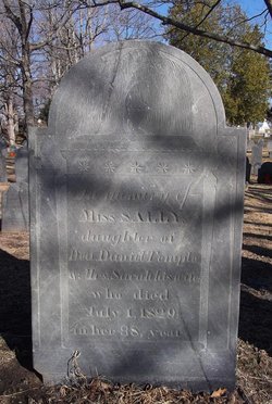
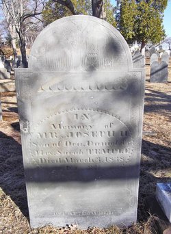
Sally Temple
| Birth | : | 23 Aug 1791 |
| Death | : | 1 Jul 1829 Reading, Middlesex County, Massachusetts, USA |
| Burial | : | Lindquist Memorial Park, Layton, Davis County, USA |
| Coordinate | : | 41.0869210, -111.9504260 |
| Description | : | She died in her 38th year. (source: Vital Records of Reading, MA to the end of the year 1849) |
frequently asked questions (FAQ):
-
Where is Sally Temple's memorial?
Sally Temple's memorial is located at: Lindquist Memorial Park, Layton, Davis County, USA.
-
When did Sally Temple death?
Sally Temple death on 1 Jul 1829 in Reading, Middlesex County, Massachusetts, USA
-
Where are the coordinates of the Sally Temple's memorial?
Latitude: 41.0869210
Longitude: -111.9504260
Family Members:
Parent
Siblings

Flowers:


Nearby Cemetories:
1. Lindquist Memorial Park
Layton, Davis County, USA
Coordinate: 41.0869210, -111.9504260
2. Layton Hill Cemetery
Layton, Davis County, USA
Coordinate: 41.0988000, -111.9746300
3. Adams Gravesite
Layton, Davis County, USA
Coordinate: 41.0668880, -111.9099400
4. Kaysville City Cemetery
Kaysville, Davis County, USA
Coordinate: 41.0449982, -111.9263992
5. Clearfield City Cemetery
Clearfield, Davis County, USA
Coordinate: 41.0983009, -112.0102997
6. South Weber Cemetery
South Weber, Davis County, USA
Coordinate: 41.1425018, -111.9693985
7. Uintah Cemetery
Uintah, Weber County, USA
Coordinate: 41.1458015, -111.9421997
8. Syracuse Cemetery
Syracuse, Davis County, USA
Coordinate: 41.0960999, -112.0456009
9. Lindquists Memorial Gardens of the Wasatch
South Ogden, Weber County, USA
Coordinate: 41.1631012, -111.9321976
10. Clinton City Cemetery
Clinton, Davis County, USA
Coordinate: 41.1260986, -112.0402985
11. Washington Heights Memorial Park
South Ogden, Weber County, USA
Coordinate: 41.1779900, -111.9700600
12. Roy City Cemetery
Roy, Weber County, USA
Coordinate: 41.1680984, -112.0353012
13. Weber County Poor Farm Cemetery
Roy, Weber County, USA
Coordinate: 41.1613200, -112.0458700
14. William O Smith Farm Cemetery
Farmington, Davis County, USA
Coordinate: 40.9849030, -111.8939710
15. Aultorest Memorial Park
Ogden, Weber County, USA
Coordinate: 41.2005997, -111.9610977
16. West Point Cemetery
West Point, Davis County, USA
Coordinate: 41.1142006, -112.0997009
17. Farmington City Cemetery
Farmington, Davis County, USA
Coordinate: 40.9723100, -111.8832200
18. Mountain Green Cemetery
Mountain Green, Morgan County, USA
Coordinate: 41.1450005, -111.8022003
19. Peterson Cemetery
Morgan, Morgan County, USA
Coordinate: 41.1086006, -111.7758026
20. Good Shepherd Columbarium
Ogden, Weber County, USA
Coordinate: 41.2231000, -111.9731000
21. Ogden City Cemetery
Ogden, Weber County, USA
Coordinate: 41.2324982, -111.9621964
22. Tiffany Mack Memorial Pet Cemetery
Ogden, Weber County, USA
Coordinate: 41.2342300, -111.9600900
23. Enterprise Cemetery
Enterprise, Morgan County, USA
Coordinate: 41.1091000, -111.7450000
24. Hooper City Cemetery
Hooper, Weber County, USA
Coordinate: 41.1666985, -112.1306000