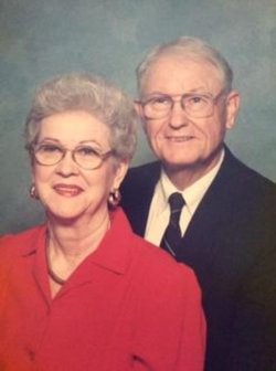
| Birth | : | 4 Sep 1898 Marion County, South Carolina, USA |
| Death | : | 24 Apr 1956 Mullins, Marion County, South Carolina, USA |
| Burial | : | Cedardale Cemetery, Mullins, Marion County, USA |
| Coordinate | : | 34.2211990, -79.2584991 |
| Description | : | Son of John Wesley and Agnes Byrd Harrelson. Sam arried Minnie Mae Frye on January 8, 1920. |
frequently asked questions (FAQ):
-
Where is Sam Clyde Harrelson's memorial?
Sam Clyde Harrelson's memorial is located at: Cedardale Cemetery, Mullins, Marion County, USA.
-
When did Sam Clyde Harrelson death?
Sam Clyde Harrelson death on 24 Apr 1956 in Mullins, Marion County, South Carolina, USA
-
Where are the coordinates of the Sam Clyde Harrelson's memorial?
Latitude: 34.2211990
Longitude: -79.2584991
Family Members:
Parent
Spouse
Siblings
Children
Flowers:
Nearby Cemetories:
1. Cedardale Cemetery
Mullins, Marion County, USA
Coordinate: 34.2211990, -79.2584991
2. Norton's Memorial Park
Mullins, Marion County, USA
Coordinate: 34.2211571, -79.2581635
3. Mayers Memorial Park
Mullins, Marion County, USA
Coordinate: 34.2205009, -79.2578964
4. Rogers-Perritt Cemetery
Marion County, USA
Coordinate: 34.2200600, -79.2774300
5. Old Field Cemetery
Marion County, USA
Coordinate: 34.2310982, -79.2394028
6. Hill Crest Cemetery
Mullins, Marion County, USA
Coordinate: 34.2319300, -79.2380620
7. Progressive Church Of Our Lord Jesus Christ
Mullins, Marion County, USA
Coordinate: 34.2080820, -79.2370870
8. Miller's United Methodist Church Cemetery
Mullins, Marion County, USA
Coordinate: 34.2468681, -79.2460861
9. Effingham Baptist Church Cemetery
Mullins, Marion County, USA
Coordinate: 34.2090780, -79.2900270
10. McMillan Cemetery
Mullins, Marion County, USA
Coordinate: 34.2092018, -79.2213974
11. Pleasant Hill United Methodist Church Cemetery
Mullins, Marion County, USA
Coordinate: 34.2390000, -79.2936500
12. Harrelson Cemetery
Mullins, Marion County, USA
Coordinate: 34.2535700, -79.2738500
13. Cribb Cemetery
Marion County, USA
Coordinate: 34.2563600, -79.2687000
14. John Campbell Family Cemetery
Mullins, Marion County, USA
Coordinate: 34.2567500, -79.2687700
15. Cribb Cemetery
Fork, Dillon County, USA
Coordinate: 34.2672500, -79.2563200
16. Edwards Cemetery
Smithboro, Marion County, USA
Coordinate: 34.2649700, -79.2813100
17. Smith Cemetery
Mullins, Marion County, USA
Coordinate: 34.2097200, -79.2006600
18. Tranquil Methodist Church Cemetery
Marion, Marion County, USA
Coordinate: 34.2004000, -79.3128000
19. Shooter-Lewis Family Cemetery
Dillon County, USA
Coordinate: 34.2695410, -79.2419390
20. Center UMC Cemetery
Mullins, Marion County, USA
Coordinate: 34.2075970, -79.1990020
21. McClellan-Mason Family Cemetery
Fork, Dillon County, USA
Coordinate: 34.2733994, -79.2634964
22. Old Buck Swamp Baptist Site Cemetery
Dillon County, USA
Coordinate: 34.2691690, -79.2246120
23. Mill Creek Baptist Church Cemetery
Mullins, Marion County, USA
Coordinate: 34.2086800, -79.1921870
24. Mullins Cemetery
Mullins, Marion County, USA
Coordinate: 34.1779000, -79.2148000


