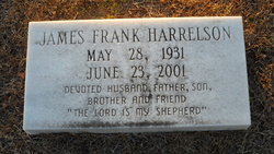
James Frank Harrelson
| Birth | : | 28 May 1931 Mullins, Marion County, South Carolina, USA |
| Death | : | 23 Jun 2001 Marion, Marion County, South Carolina, USA |
| Burial | : | Spring Branch Cemetery, Spring Branch, Marion County, USA |
| Coordinate | : | 34.2425003, -79.3925018 |
| Inscription | : | "The Lord is my shepherd" |
| Description | : | KOREA Son of Sam Clyde and Minnie Mae Frye Harrelson, husband of Ora Elizabeth Edwards. MULLINS - Funeral services for J. Frank Harrelson, 70, of 5212 Orchard Road, will be held at 2 p.m. Tuesday, June 26, 2001, at First United Methodist Church of Marion with the Rev. Dennis Lee and Dr. W. Ches Smith III officiating. Burial will follow in Spring Branch Cemetery directed by Cox-Collins Funeral Home. Mr. Harrelson died Saturday, June 23, 2001, at Marion County Medical Center. Born May 28, 1931 in Marion County, he was a son of the late Sam... Read More |
frequently asked questions (FAQ):
-
Where is James Frank Harrelson's memorial?
James Frank Harrelson's memorial is located at: Spring Branch Cemetery, Spring Branch, Marion County, USA.
-
When did James Frank Harrelson death?
James Frank Harrelson death on 23 Jun 2001 in Marion, Marion County, South Carolina, USA
-
Where are the coordinates of the James Frank Harrelson's memorial?
Latitude: 34.2425003
Longitude: -79.3925018
Family Members:
Parent
Spouse
Siblings
Flowers:
Nearby Cemetories:
1. Spring Branch Cemetery
Spring Branch, Marion County, USA
Coordinate: 34.2425003, -79.3925018
2. Spring Branch Baptist Church Cemetery
Spring Branch, Marion County, USA
Coordinate: 34.2420998, -79.3957977
3. Greater Fork Chapel AME Church Cemetery
Marion, Marion County, USA
Coordinate: 34.2496986, -79.3929977
4. Wall Mausoleum
Marion, Marion County, USA
Coordinate: 34.2344800, -79.3823000
5. Saint Phillips United Methodist Church Cemetery
Spring Branch, Marion County, USA
Coordinate: 34.2491700, -79.4062600
6. Sunset Gardens Cemetery
Spring Branch, Marion County, USA
Coordinate: 34.2500300, -79.4057900
7. Moody-Berry Cemetery
Marion County, USA
Coordinate: 34.2564011, -79.3908005
8. End of the Road Cemetery
Marion, Marion County, USA
Coordinate: 34.2240620, -79.3912079
9. Moody Cemetery
Marion, Marion County, USA
Coordinate: 34.2548409, -79.4154968
10. Platt - Deer Cemetery
Marion, Marion County, USA
Coordinate: 34.2675876, -79.3959196
11. Gasque Cemetery
Marion County, USA
Coordinate: 34.2098000, -79.3971300
12. Bethlehem Freewill Baptist Church Cemetery
Marion, Marion County, USA
Coordinate: 34.2806200, -79.3820900
13. Lane Cemetery
Temperance Hill, Marion County, USA
Coordinate: 34.2860985, -79.3891983
14. Perritt Cemetery
Zion, Marion County, USA
Coordinate: 34.2533600, -79.3386700
15. Ebenezer Methodist Church Cemetery
Temperance Hill, Marion County, USA
Coordinate: 34.2858009, -79.4105988
16. Stewart Family Cemetery
Marion County, USA
Coordinate: 34.2888985, -79.3861008
17. Union Baptist Church Cemetery
Temperance Hill, Marion County, USA
Coordinate: 34.2871475, -79.3754730
18. Turner Cemetery
Marion County, USA
Coordinate: 34.2860985, -79.4163971
19. Bryant Cemetery
Marion County, USA
Coordinate: 34.2903800, -79.3764400
20. Lane Cemetery
Marion, Marion County, USA
Coordinate: 34.2337760, -79.3279730
21. Martin-Stephens Cemetery
Marion, Marion County, USA
Coordinate: 34.2331020, -79.3273400
22. Lee Cemetery
Marion County, USA
Coordinate: 34.2971992, -79.3918991
23. Christmas Cemetery
Sellers, Marion County, USA
Coordinate: 34.2841988, -79.4381027
24. Tyndall Cemetery
Dillon County, USA
Coordinate: 34.2942009, -79.3602982


