
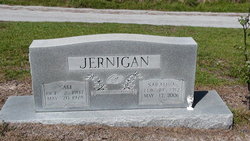
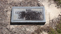
Sam D. Jernigan
| Birth | : | 2 Oct 1907 Horry County, South Carolina, USA |
| Death | : | 20 May 1978 |
| Burial | : | Ongar Town Cemetery, Ongar, Epping Forest District, England |
| Coordinate | : | 51.7083700, 0.2460300 |
frequently asked questions (FAQ):
-
Where is Sam D. Jernigan's memorial?
Sam D. Jernigan's memorial is located at: Ongar Town Cemetery, Ongar, Epping Forest District, England.
-
When did Sam D. Jernigan death?
Sam D. Jernigan death on 20 May 1978 in
-
Where are the coordinates of the Sam D. Jernigan's memorial?
Latitude: 51.7083700
Longitude: 0.2460300
Family Members:
Parent
Spouse

Siblings
Children


Nearby Cemetories:
1. Ongar Town Cemetery
Ongar, Epping Forest District, England
Coordinate: 51.7083700, 0.2460300
2. St Mary the Virgin Churchyard
High Ongar, Epping Forest District, England
Coordinate: 51.7107790, 0.2641610
3. St Andrew Churchyard
Greensted, Epping Forest District, England
Coordinate: 51.7044040, 0.2255110
4. St. Peter and St. Paul Churchyard
Stondon Massey, Brentwood Borough, England
Coordinate: 51.6910510, 0.2738590
5. St Margaret Churchyard
Stanford Rivers, Epping Forest District, England
Coordinate: 51.6856990, 0.2177360
6. St Nicholas Churchyard
Fyfield, Epping Forest District, England
Coordinate: 51.7374230, 0.2760330
7. St. Nicholas Churchyard
Kelvedon Hatch, Brentwood Borough, England
Coordinate: 51.6675310, 0.2674380
8. St Thomas the Apostle Churchyard
Navestock, Brentwood Borough, England
Coordinate: 51.6630500, 0.2259120
9. All Saints Churchyard
High Laver, Epping Forest District, England
Coordinate: 51.7559060, 0.2117340
10. St Andrew and All Saints Churchyard
Willingale, Epping Forest District, England
Coordinate: 51.7417800, 0.3106800
11. St. Andrew's Churchyard
North Weald Bassett, Epping Forest District, England
Coordinate: 51.7254630, 0.1638090
12. North Weald Bassett Cemetery
North Weald Bassett, Epping Forest District, England
Coordinate: 51.7254250, 0.1622850
13. St Mary the Virgin Churchyard
Little Laver, Epping Forest District, England
Coordinate: 51.7642100, 0.2372400
14. St Mary the Virgin Churchyard
Stapleford Tawney, Epping Forest District, England
Coordinate: 51.6698230, 0.1719070
15. St Paul Bentley Common Churchyard
Brentwood, Brentwood Borough, England
Coordinate: 51.6468925, 0.2628140
16. Ss Peter & Paul Churchyard
Shellow Bowells, Epping Forest District, England
Coordinate: 51.7465000, 0.3262700
17. St Michael Churchyard
Theydon Mount, Epping Forest District, England
Coordinate: 51.6721100, 0.1574700
18. Brentwood Jewish Cemetery
Coxtie Green, Brentwood Borough, England
Coordinate: 51.6420580, 0.2488660
19. Bentley Cemetery and Crematorium
Brentwood Borough, England
Coordinate: 51.6424381, 0.2740605
20. St Alban the Martyr Churchyard
Coopersale, Epping Forest District, England
Coordinate: 51.7020000, 0.1338200
21. St Edmund Churchyard
Abbess Roding, Epping Forest District, England
Coordinate: 51.7794180, 0.2771470
22. All Saints churchyard
Berners Roding, Epping Forest District, England
Coordinate: 51.7660070, 0.3201910
23. Harlow Baptist Burial Ground
Harlow, Harlow District, England
Coordinate: 51.7619700, 0.1584330
24. St Mary the Virgin Churchyard
Matching, Epping Forest District, England
Coordinate: 51.7855000, 0.2098000