
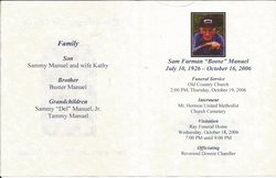


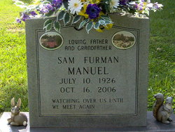
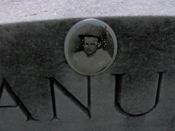
Sam Furman “Boose” Manuel
| Birth | : | 10 Jul 1926 Stokes County, North Carolina, USA |
| Death | : | 16 Oct 2006 Rockingham County, North Carolina, USA |
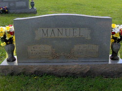
| Burial | : | Mount Hermon United Methodist Church Cemetery, Madison, Rockingham County, USA |
| Coordinate | : | 36.4283160, -80.0296580 |
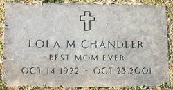
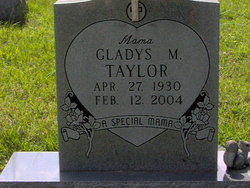
| Description | : | Mr. Sam Furman "Boose" Manuel, 80, of 575 Dairy Road, died Monday, October 16, 2006, at Annie Penn Memorial Hospital. Funeral services will be held at 2 p.m. Thursday, October 19, at Old Country Church with the Reverend Donnie Chandler officiating. Interment will follow in the Mt. Hermon United Methodist Church Cemetery. Mr. Manuel was born on July 10, 1926, in Stokes County, the son of the late Grant Manuel and the late Pearlie Smith Manuel. He was a retired farmer. In addition to his parents, he was preceded in death by his sisters, Lola Chandler, Gladys Taylor, and Lillie... Read More |
frequently asked questions (FAQ):
-
Where is Sam Furman “Boose” Manuel's memorial?
Sam Furman “Boose” Manuel's memorial is located at: Mount Hermon United Methodist Church Cemetery, Madison, Rockingham County, USA.
-
When did Sam Furman “Boose” Manuel death?
Sam Furman “Boose” Manuel death on 16 Oct 2006 in Rockingham County, North Carolina, USA
-
Where are the coordinates of the Sam Furman “Boose” Manuel's memorial?
Latitude: 36.4283160
Longitude: -80.0296580
Family Members:
Parent

Siblings

Flowers:


Nearby Cemetories:
1. Mount Hermon United Methodist Church Cemetery
Madison, Rockingham County, USA
Coordinate: 36.4283160, -80.0296580
2. Nelson Family Cemetery
Madison, Rockingham County, USA
Coordinate: 36.4279320, -80.0294220
3. Freeman Family Cemetery
Stokes County, USA
Coordinate: 36.4265670, -80.0441620
4. Brim Cemetery
Dillard, Stokes County, USA
Coordinate: 36.4166420, -80.0466760
5. Community Baptist Church Cemetery
Mayodan, Rockingham County, USA
Coordinate: 36.4468920, -80.0295150
6. Gann Cemetery
Rockingham County, USA
Coordinate: 36.4311950, -80.0066800
7. Hunter Cemetery
Madison, Rockingham County, USA
Coordinate: 36.4405730, -80.0059740
8. Price Family Cemetery
Beaver Island, Stokes County, USA
Coordinate: 36.4147300, -80.0527180
9. Webster's Cemetery
Beaver Island, Stokes County, USA
Coordinate: 36.4137380, -80.0544640
10. Joyce Family Cemetery
Beaver Island, Stokes County, USA
Coordinate: 36.4505740, -80.0464350
11. Old Country Church
Madison, Rockingham County, USA
Coordinate: 36.4126015, -79.9987030
12. Goodwill Baptist Church Cemetery
Madison, Rockingham County, USA
Coordinate: 36.3947360, -80.0228310
13. Martin Cemetery
Ayersville, Rockingham County, USA
Coordinate: 36.4612240, -80.0172890
14. Clearview Baptist Church Cemetery
Mayodan, Rockingham County, USA
Coordinate: 36.4224170, -79.9843980
15. Martin View Church Cemetery
Mayodan, Rockingham County, USA
Coordinate: 36.4565269, -79.9994876
16. Oak Grove Baptist Church Cemetery
Dillard, Stokes County, USA
Coordinate: 36.4221080, -80.0841210
17. Beaver Island Baptist Church Cemetery
Rockingham County, USA
Coordinate: 36.4570007, -79.9870987
18. Cardwell Cemetery
Madison, Rockingham County, USA
Coordinate: 36.4063500, -79.9801730
19. Foy-Gibson Cemetery
Rockingham County, USA
Coordinate: 36.3852921, -80.0071640
20. Llewellyn Cemetery
Mayodan, Rockingham County, USA
Coordinate: 36.4502983, -79.9768982
21. Mayodan Municipal Cemetery
Mayodan, Rockingham County, USA
Coordinate: 36.4079090, -79.9749350
22. Griffin Family Cemetery
Rockingham County, USA
Coordinate: 36.4240720, -79.9679370
23. Mitchell Cemetery
Dillard, Stokes County, USA
Coordinate: 36.4114050, -80.0891200
24. Old Mayodan Municipal Cemetery
Mayodan, Rockingham County, USA
Coordinate: 36.4089300, -79.9704900