
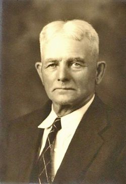

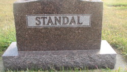
Samson Lyder Elias Olsen Standal
| Birth | : | 24 Jul 1864 Floro, Flora kommune, Sogn og Fjordane fylke, Norway |
| Death | : | 1 Jul 1943 Binford, Griggs County, North Dakota, USA |
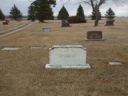
| Burial | : | Blessed Virgin Mary Churchyard, Woolavington, Sedgemoor District, England |
| Coordinate | : | 51.1704000, -2.9341000 |
| Inscription | : | Father |
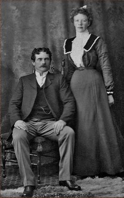
| Description | : | Samson Lyder Elias Olsen Standal was born at a farm named Nedre Standal in Flora Kommune, Sogn og Fjordane, Norway. He emigrated from Bergen on 10, August 1888 and came to Dazey, North Dakota to work with the Railroad. He married Randine Johnsdatter on 29, December 1901 in Rosendal Township, Griggs County, and lived the remainder of his life in Binford, where he died in his home. Funeral services for Sam Standal, 78, who died at his home in Binford, July1, were held July 3 in Binford Trinity Lutheran Church with Rev. J. Loland officiating. Mr. Standal... Read More |
frequently asked questions (FAQ):
-
Where is Samson Lyder Elias Olsen Standal's memorial?
Samson Lyder Elias Olsen Standal's memorial is located at: Blessed Virgin Mary Churchyard, Woolavington, Sedgemoor District, England.
-
When did Samson Lyder Elias Olsen Standal death?
Samson Lyder Elias Olsen Standal death on 1 Jul 1943 in Binford, Griggs County, North Dakota, USA
-
Where are the coordinates of the Samson Lyder Elias Olsen Standal's memorial?
Latitude: 51.1704000
Longitude: -2.9341000
Family Members:
Spouse
Children

Flowers:


Nearby Cemetories:
1. Blessed Virgin Mary Churchyard
Woolavington, Sedgemoor District, England
Coordinate: 51.1704000, -2.9341000
2. Blessed Virgin Mary Extension Cemetery
Woolavington, Sedgemoor District, England
Coordinate: 51.1705660, -2.9329110
3. St. Mary's Churchyard
Cossington, Sedgemoor District, England
Coordinate: 51.1580085, -2.9213149
4. Saint Michael & All Angels Churchyard
Bawdrip, Sedgemoor District, England
Coordinate: 51.1517260, -2.9429330
5. Saint Michael and All Angels Churchyard
Puriton, Sedgemoor District, England
Coordinate: 51.1706000, -2.9735000
6. St Edwards Churchyard
Chilton Polden, Sedgemoor District, England
Coordinate: 51.1554490, -2.8972091
7. All Saints Churchyard
East Huntspill, Sedgemoor District, England
Coordinate: 51.2015000, -2.9405700
8. St. Francis Churchyard
Stawell, Sedgemoor District, England
Coordinate: 51.1404200, -2.9046660
9. Church of the Blessed Virgin Mary Churchyard
Chedzoy, Sedgemoor District, England
Coordinate: 51.1344600, -2.9429400
10. Saint George Churchyard
Edington, Sedgemoor District, England
Coordinate: 51.1540010, -2.8778350
11. St. John The Baptist Churchyard
Pawlett, Sedgemoor District, England
Coordinate: 51.1789100, -3.0012650
12. St. Philip and St. James Churchyard
Burtle, Sedgemoor District, England
Coordinate: 51.1856232, -2.8665409
13. Sedgemoor Crematorium
Sedgemoor District, England
Coordinate: 51.1909300, -3.0005180
14. Saint Peter Churchyard
Catcott, Sedgemoor District, England
Coordinate: 51.1494920, -2.8671220
15. St. John Bristol Road Cemetery
Bridgwater, Sedgemoor District, England
Coordinate: 51.1391470, -2.9901660
16. Sutton Mallet Churchyard
Sutton Mallet, Sedgemoor District, England
Coordinate: 51.1282540, -2.8974536
17. Pawlett Methodist (Carter Memorial Wesleyan)
Pawlett, Sedgemoor District, England
Coordinate: 51.1845660, -3.0126480
18. Holy Trinity Churchyard
Chilton Trinity, Sedgemoor District, England
Coordinate: 51.1474390, -3.0072360
19. Saint Peter and All Hallows Churchyard
West Huntspill, Sedgemoor District, England
Coordinate: 51.2041900, -2.9966370
20. St John The Baptist Churchyard
Bridgwater, Sedgemoor District, England
Coordinate: 51.1311160, -2.9969910
21. Highbridge Cemetery
Highbridge, Sedgemoor District, England
Coordinate: 51.2249430, -2.9741730
22. Westonzoyland Cemetery New
Westonzoyland, Sedgemoor District, England
Coordinate: 51.1096271, -2.9349336
23. Former Holy Trinity Churchyard
Bridgwater, Sedgemoor District, England
Coordinate: 51.1261850, -3.0021850
24. St. Mary's Churchyard
Bridgwater, Sedgemoor District, England
Coordinate: 51.1277430, -3.0050330