
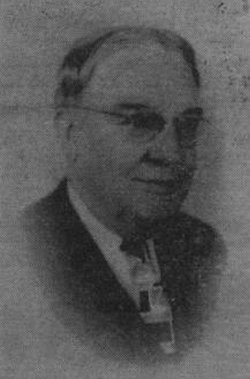

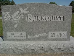
Samuel Adrian Burnquist
| Birth | : | 17 Apr 1878 Dayton, Webster County, Iowa, USA |
| Death | : | 24 Dec 1965 Fort Dodge, Webster County, Iowa, USA |
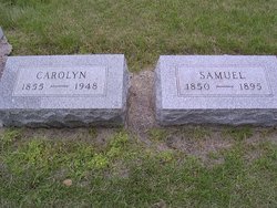
| Burial | : | Dayton Cemetery, Dayton, Webster County, USA |
| Coordinate | : | 42.2675000, -94.0755000 |
| Description | : | Dayton Review December 30, 1965 Services held for Samuel Burnquist, 87, Tuesday, Dec. 28 Funeral services were held for Samuel A. Burnquist, long-time Dayton resident Tuesday, December 28 at 1:30 p.m. in the Dayton Methodist Church. Rev. Donald Artman conducted the service with the Carson Funeral Home in charge of the arrangements. During the service a vocal selection was presented by Mr. Richard Will accompanied by Mrs. Carl Benson. Caring for the flowers were Mrs. Glen Beckman, Mrs. Mildred Vegors and Mrs. Roberta McIlvain. Bearers were Ralph Bowman, Van Gabrielson, Dean Jordan, Leo Luhmann, Ivan Skoglund and Robert Young. Interment was held in the... Read More |
frequently asked questions (FAQ):
-
Where is Samuel Adrian Burnquist's memorial?
Samuel Adrian Burnquist's memorial is located at: Dayton Cemetery, Dayton, Webster County, USA.
-
When did Samuel Adrian Burnquist death?
Samuel Adrian Burnquist death on 24 Dec 1965 in Fort Dodge, Webster County, Iowa, USA
-
Where are the coordinates of the Samuel Adrian Burnquist's memorial?
Latitude: 42.2675000
Longitude: -94.0755000
Family Members:
Parent
Spouse
Siblings


Flowers:


Nearby Cemetories:
1. Dayton Cemetery
Dayton, Webster County, USA
Coordinate: 42.2675000, -94.0755000
2. Christ the King Catholic Cemetery
Dayton, Webster County, USA
Coordinate: 42.2601929, -94.0727539
3. Bass Cemetery
Dayton, Webster County, USA
Coordinate: 42.2966995, -94.0149994
4. Swedish Lutheran Church Cemetery
Dayton, Webster County, USA
Coordinate: 42.2175000, -94.1065000
5. Oak Grove Cemetery
Lehigh, Webster County, USA
Coordinate: 42.3438988, -94.0475006
6. Hardin Township Cemetery
Hardin Township, Webster County, USA
Coordinate: 42.2411003, -93.9708023
7. Linn Cemetery
Pilot Mound, Boone County, USA
Coordinate: 42.2045330, -93.9970230
8. Lawn Cemetery
Boone County, USA
Coordinate: 42.1771011, -94.0867996
9. West Lawn Cemetery
Lehigh, Webster County, USA
Coordinate: 42.3616982, -94.0678024
10. McGuire Bend Cemetery
Dayton, Webster County, USA
Coordinate: 42.3410000, -93.9880000
11. Runyan Cemetery
Pilot Mound, Boone County, USA
Coordinate: 42.1749992, -94.0015030
12. Pilot Mound Cemetery
Pilot Mound, Boone County, USA
Coordinate: 42.1636200, -94.0282600
13. Vegors Cemetery
Webster County, USA
Coordinate: 42.3177986, -93.9421997
14. Lost Grove Cemetery
Harcourt, Webster County, USA
Coordinate: 42.2583008, -94.2331009
15. Hooks Point Cemetery
Hamilton County, USA
Coordinate: 42.2944530, -93.9199090
16. Oakwood Cemetery
Stratford, Hamilton County, USA
Coordinate: 42.2942009, -93.9182968
17. Hartman Cemetery
Lehigh, Webster County, USA
Coordinate: 42.3666397, -93.9835627
18. White Cemetery
Boone County, USA
Coordinate: 42.1777992, -93.9636002
19. Border Plains Cemetery
Border Plains, Webster County, USA
Coordinate: 42.3917000, -94.0448000
20. Ober and Scott Cemetery
Duncombe, Webster County, USA
Coordinate: 42.3841390, -93.9982856
21. Union Cemetery
Boxholm, Boone County, USA
Coordinate: 42.1369019, -94.0852966
22. Renner Cemetery
Boone County, USA
Coordinate: 42.1380420, -94.1256570
23. Otho Cemetery
Otho, Webster County, USA
Coordinate: 42.4025002, -94.1153030
24. Schlicht Cemetery
Fraser, Boone County, USA
Coordinate: 42.1444200, -93.9780100