
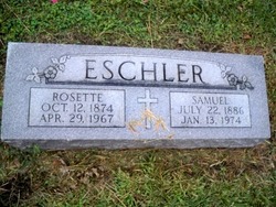
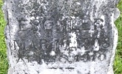
Samuel Eschler
| Birth | : | 22 Jul 1886 Platte County, Nebraska, USA |
| Death | : | 13 Jan 1974 Platte County, Nebraska, USA |
| Burial | : | West Cemetery, Benton, Grafton County, USA |
| Coordinate | : | 44.1033700, -71.9014000 |
frequently asked questions (FAQ):
-
Where is Samuel Eschler's memorial?
Samuel Eschler's memorial is located at: West Cemetery, Benton, Grafton County, USA.
-
When did Samuel Eschler death?
Samuel Eschler death on 13 Jan 1974 in Platte County, Nebraska, USA
-
Where are the coordinates of the Samuel Eschler's memorial?
Latitude: 44.1033700
Longitude: -71.9014000
Family Members:
Parent

Spouse

Siblings

Children
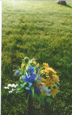
Flowers:


Nearby Cemetories:
1. West Cemetery
Benton, Grafton County, USA
Coordinate: 44.1033700, -71.9014000
2. East Cemetery
Benton, Grafton County, USA
Coordinate: 44.0985985, -71.8846970
3. Swiftwater Cemetery
Bath, Grafton County, USA
Coordinate: 44.1303400, -71.9574300
4. Brown Farmstead Cemetery
Benton, Grafton County, USA
Coordinate: 44.0778000, -71.8420830
5. Center Haverhill Cemetery
Center Haverhill, Grafton County, USA
Coordinate: 44.0770650, -71.9868740
6. Landaff Center Cemetery
Landaff, Grafton County, USA
Coordinate: 44.1739860, -71.8847040
7. Bath Village Cemetery
Bath, Grafton County, USA
Coordinate: 44.1693500, -71.9617800
8. Number 6 Cemetery
East Haverhill, Grafton County, USA
Coordinate: 44.0326400, -71.9518600
9. Abbott Cemetery
North Haverhill, Grafton County, USA
Coordinate: 44.0821730, -72.0186420
10. Pine Grove Cemetery
Woodsville, Grafton County, USA
Coordinate: 44.1380997, -72.0188980
11. Kinsman Cemetery
Easton, Grafton County, USA
Coordinate: 44.1374900, -71.7808700
12. Easton Cemetery
Easton, Grafton County, USA
Coordinate: 44.1375000, -71.7805560
13. West Bath Cemetery
Bath, Grafton County, USA
Coordinate: 44.1750930, -71.9865080
14. Noyes Cemetery
Landaff, Grafton County, USA
Coordinate: 44.1830560, -71.8286110
15. East Haverhill Cemetery
East Haverhill, Grafton County, USA
Coordinate: 44.0289688, -71.9889297
16. Horse Meadow Cemetery
North Haverhill, Grafton County, USA
Coordinate: 44.1068880, -72.0405500
17. Horse Meadow Annex Cemetery
North Haverhill, Grafton County, USA
Coordinate: 44.1056820, -72.0408260
18. Oliverian Road Cemetery
Benton, Grafton County, USA
Coordinate: 43.9978145, -71.9209265
19. Oxbow Cemetery
Newbury, Orange County, USA
Coordinate: 44.0881830, -72.0486670
20. Grove Hill Cemetery
Lisbon, Grafton County, USA
Coordinate: 44.2108002, -71.9094009
21. Pettyboro District Cemetery
Pettyboro, Grafton County, USA
Coordinate: 44.2038310, -71.9620880
22. High Street Cemetery
Glencliff, Grafton County, USA
Coordinate: 43.9851100, -71.8913900
23. Wells River Cemetery
Wells River, Orange County, USA
Coordinate: 44.1535988, -72.0547028
24. Lund Cemetery
Warren, Grafton County, USA
Coordinate: 43.9882800, -71.9589200